Horbach, Westerwaldkreis
Horbach is an Ortsgemeinde – a community belonging to a Verbandsgemeinde – in the Westerwaldkreis in Rhineland-Palatinate, Germany.
Horbach | |
|---|---|
 | |
_COA.svg.png.webp) Coat of arms | |
Location of Horbach within Westerwaldkreis district 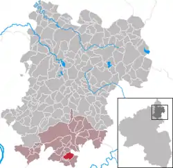 | |
 Horbach  Horbach | |
| Coordinates: 50°22′23″N 7°51′10″E | |
| Country | Germany |
| State | Rhineland-Palatinate |
| District | Westerwaldkreis |
| Municipal assoc. | Montabaur |
| Government | |
| • Mayor (2019–24) | Christoph Büttner[1] |
| Area | |
| • Total | 3.94 km2 (1.52 sq mi) |
| Elevation | 305 m (1,001 ft) |
| Population (2021-12-31)[2] | |
| • Total | 690 |
| • Density | 180/km2 (450/sq mi) |
| Time zone | UTC+01:00 (CET) |
| • Summer (DST) | UTC+02:00 (CEST) |
| Postal codes | 56412 |
| Dialling codes | 06439 |
| Vehicle registration | WW |
| Website | www.vg-montabaur.de |
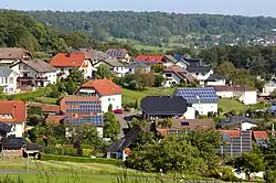
Geography
The community lies in the Westerwald south of Montabaur in the Nassau Nature Park. The community belongs to the Verbandsgemeinde of Montabaur, a kind of collective municipality.
History
In 1486, Horbach had its first documentary mention.
Politics
Community council
The council is made up of 12 council members who were elected in a majority vote in a municipal election on 13 June 2004.
Coat of arms
Horbach's location in the so-called Buchfinkenländchen is symbolized by the common chaffinch in the community's arms. The wavy bend stands for one of the headwater streams that builds the Daubach, which rises in Horbach. The heraldic lily refers to the name's meaning (horo = swamp), recalling as it does a kind of lily that grows in wetlands. The tinctures red and silver were the heraldic colours borne by the Electorate of Trier.
Economy and infrastructure
The nearest Autobahn interchange is Montabaur on the A 3 (Cologne–Frankfurt) some 9 km away.
References
- Direktwahlen 2019, Westerwaldkreis, Landeswahlleiter Rheinland-Pfalz, accessed 9 August 2021.
- "Bevölkerungsstand 2021, Kreise, Gemeinden, Verbandsgemeinden" (in German). Statistisches Landesamt Rheinland-Pfalz. 2022.
External links