Moschheim
Moschheim is an Ortsgemeinde – a community belonging to a Verbandsgemeinde – in the Westerwaldkreis in Rhineland-Palatinate, Germany.
Moschheim | |
|---|---|
 Coat of arms | |
Location of Moschheim within Westerwaldkreis district 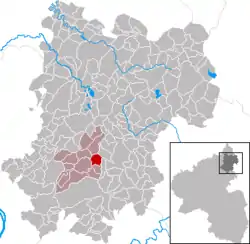 | |
 Moschheim  Moschheim | |
| Coordinates: 50°28′57″N 7°50′30″E | |
| Country | Germany |
| State | Rhineland-Palatinate |
| District | Westerwaldkreis |
| Municipal assoc. | Wirges |
| Government | |
| • Mayor (2019–24) | Norbert Nöller[1] |
| Area | |
| • Total | 3.44 km2 (1.33 sq mi) |
| Elevation | 272 m (892 ft) |
| Population (2021-12-31)[2] | |
| • Total | 750 |
| • Density | 220/km2 (560/sq mi) |
| Time zone | UTC+01:00 (CET) |
| • Summer (DST) | UTC+02:00 (CEST) |
| Postal codes | 56424 |
| Dialling codes | 02602 |
| Vehicle registration | WW |
| Website | www.moschheim.de |
Geography
The community lies north of Montabaur on the Kannenbäckerstraße (“Jug Bakers’ Road”, a reference to the local ceramics industry). The community has since 1971 belonged to what was then the newly founded Verbandsgemeinde of Wirges, a kind of collective municipality. Its seat is in the like-named town.
In the north of the municipal area stands the Malberg, which at 422 m above sea level is one of the greatest elevations in the area.
History
In 1362, Moschheim had its first documentary mention.
Politics
The municipal council is made up of 13 council members, including the extraofficial mayor (Bürgermeister), who were elected in a majority vote in a municipal election on 13 June 2004.
Economy and infrastructure
East of the community runs Bundesstraße 255, linking Montabaur and Rennerod. The nearest Autobahn interchange is Montabaur on the A 3 (Cologne–Frankfurt), some 3 km away. The nearest InterCityExpress stop is the railway station at Montabaur on the Cologne-Frankfurt high-speed rail line.
References
- Direktwahlen 2019, Westerwaldkreis, Landeswahlleiter Rheinland-Pfalz, accessed 9 August 2021.
- "Bevölkerungsstand 2021, Kreise, Gemeinden, Verbandsgemeinden" (in German). Statistisches Landesamt Rheinland-Pfalz. 2022.
External links
- Moschheim (in German)