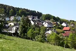
Kammerforst, Rhineland-Palatinate
Kammerforst in the Kannenbäckerland is an Ortsgemeinde – a community belonging to a Verbandsgemeinde – in the Westerwaldkreis in Rhineland-Palatinate, Germany.
Kammerforst | |
|---|---|
 | |
.svg.png.webp) Coat of arms | |
Location of Kammerforst within Westerwaldkreis district 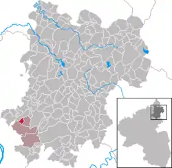 | |
 Kammerforst  Kammerforst | |
| Coordinates: 50°27′50″N 7°40′38″E | |
| Country | Germany |
| State | Rhineland-Palatinate |
| District | Westerwaldkreis |
| Municipal assoc. | Höhr-Grenzhausen |
| Government | |
| • Mayor (2019–24) | Kevin Michael Heibel[1] |
| Area | |
| • Total | 1.33 km2 (0.51 sq mi) |
| Elevation | 280 m (920 ft) |
| Population (2021-12-31)[2] | |
| • Total | 240 |
| • Density | 180/km2 (470/sq mi) |
| Time zone | UTC+01:00 (CET) |
| • Summer (DST) | UTC+02:00 (CEST) |
| Postal codes | 56206 |
| Dialling codes | 02624 |
| Vehicle registration | WW |
| Website | www.gemeinde-Kammerforst.de |
Geography
The community lies roughly 13 km northeast of Koblenz on the edge of the Nassau Nature Park. The community belongs to the Verbandsgemeinde of Höhr-Grenzhausen, a kind of collective municipality. Its seat is in the like-named town.
History
The community came into being sometime about the year 1680. It was founded by Walloon guest workers who were seeking iron ore in the area.
Politics
The municipal council is made up of 7 council members, including the extraofficial mayor (Bürgermeister), who were elected in a municipal election on 13 June 2004.
| Einzelbewerber | Total | |
| 2004 | 6 | 6 seats |
Economy and infrastructure
The A 48 with its Höhr-Grenzhausen interchange is 4 km away. The nearest InterCityExpress stop is the railway station at Montabaur on the Cologne-Frankfurt high-speed rail line or the one at Koblenz on the Rechte Rheinstrecke.
References
- Direktwahlen 2019, Westerwaldkreis, Landeswahlleiter Rheinland-Pfalz, accessed 9 August 2021.
- "Bevölkerungsstand 2021, Kreise, Gemeinden, Verbandsgemeinden" (in German). Statistisches Landesamt Rheinland-Pfalz. 2022.
External links
- Kammerforst (in German)