List of listed buildings in Cavers, Scottish Borders
List
| Name | Location | Date Listed | Grid Ref. [note 1] | Geo-coordinates | Notes | LB Number [note 2] | Image |
|---|---|---|---|---|---|---|---|
| Denholm Village, Sunnyside, Somerville House, Bonshaw And Heatherlie | 55°27′30″N 2°41′06″W | Category C(S) | 2056 | 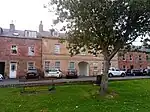
| |||
| Barns Viaduct (Stobs Viaduct) | 55°22′48″N 2°46′59″W | Category B | 2063 |  Upload Photo | |||
| Denholm, The Green, Leyden Monument | 55°27′28″N 2°41′04″W | Category C(S) | 2053 | 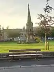
| |||
| Spittal Tower Or Towerburn | 55°27′06″N 2°39′20″W | Category B | 2065 | Upload Photo | |||
| Kirkton Church (Church Of Scotland) Including Graveyard, Boundary Walls, Gatepiers And Gates | 55°25′03″N 2°43′38″W | Category C(S) | 2046 | Upload Photo | |||
| Henlawshiel Obelisk | 55°25′06″N 2°42′15″W | Category B | 2047 | Upload Photo | |||
| Stobs Castle | 55°22′11″N 2°46′50″W | Category B | 2066 | Upload Photo | |||
| Old Church In Policies Of Cavers House | 55°25′55″N 2°43′41″W | Category B | 2045 | Upload Photo | |||
| Orchard | 55°25′35″N 2°45′11″W | Category B | 2048 | Upload Photo | |||
| Row Of Houses On The South Side Of The Green And Including The Following Properties:-The Cross Keys, P.H. House (J. Welsh) House (T.B. Hamilton) Shop-Grocer (Scott) | 55°27′27″N 2°41′02″W | Category B | 2054 | 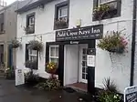
| |||
| Whitrope Tunnel, Viaduct And Culvert | 55°17′30″N 2°44′58″W | Category B | 49311 | Upload Photo | |||
| Bridge Over Teviot At Denholm | 55°27′38″N 2°41′06″W | Category C(S) | 2059 | Upload Photo | |||
| Stobs Castle Estate, Gatepiers And Black Lodge | 55°22′19″N 2°46′35″W | Category C(S) | 2062 | Upload Photo | |||
| Cavers House | 55°25′51″N 2°43′39″W | Category B | 2051 | Upload Photo | |||
| Westgate Hall, Denholm | 55°27′24″N 2°41′05″W | Category A | 2052 | 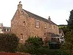
| |||
| Shankend Viaduct | 55°20′44″N 2°45′22″W | Category B | 2064 | 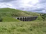
| |||
| Birthplace Of Dr John Leyden | 55°27′32″N 2°41′03″W | Category B | 2057 | 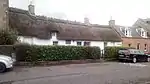
| |||
| Lodge Entrance To Stobs Castle Woodfoot | 55°22′52″N 2°46′51″W | Category B | 2060 | Upload Photo | |||
| Old Mill To Rear Of Greenview | 55°27′28″N 2°41′09″W | Category B | 158 | 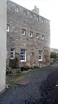
| |||
| Stobs Castle - Bridge | 55°22′15″N 2°46′40″W | Category B | 2068 | Upload Photo | |||
| Cavers Church And Graveyard | 55°26′06″N 2°43′54″W | Category B | 2044 | Upload Photo |
Key
The scheme for classifying buildings in Scotland is:
- Category A: "buildings of national or international importance, either architectural or historic; or fine, little-altered examples of some particular period, style or building type."[1]
- Category B: "buildings of regional or more than local importance; or major examples of some particular period, style or building type, which may have been altered."[1]
- Category C: "buildings of local importance; lesser examples of any period, style, or building type, as originally constructed or moderately altered; and simple traditional buildings which group well with other listed buildings."[1]
In March 2016 there were 47,288 listed buildings in Scotland. Of these, 8% were Category A, and 50% were Category B, with the remaining 42% being Category C.[2]
Notes
- Sometimes known as OSGB36, the grid reference (where provided) is based on the British national grid reference system used by the Ordnance Survey.
• "Guide to National Grid". Ordnance Survey. Retrieved 12 December 2007.
• "Get-a-map". Ordnance Survey. Retrieved 17 December 2007. - Historic Environment Scotland assign a unique alphanumeric identifier to each designated site in Scotland, for listed buildings this always begins with "LB", for example "LB12345".
References
- All entries, addresses and coordinates are based on data from Historic Scotland. This data falls under the Open Government Licence
- "What is Listing?". Historic Environment Scotland. Retrieved 29 May 2018.
- Scotland's Historic Environment Audit 2016 (PDF). Historic Environment Scotland and the Built Environment Forum Scotland. pp. 15–16. Retrieved 29 May 2018.
This article is issued from Wikipedia. The text is licensed under Creative Commons - Attribution - Sharealike. Additional terms may apply for the media files.