List of listed buildings in Edrom, Scottish Borders
List
| Name | Location | Date Listed | Grid Ref. [note 1] | Geo-coordinates | Notes | LB Number [note 2] | Image |
|---|---|---|---|---|---|---|---|
| Allanton, Blackadder Cottage And Screen Wall | 55°46′58″N 2°12′59″W | Category C(S) | 44456 |  Upload Photo | |||
| 1-3 (Inclusive) Blackadder Mount Farm Cottages | 55°46′24″N 2°13′45″W | Category C(S) | 44474 | Upload Photo | |||
| Edrom, 1 And 2 Manse Cottages | 55°47′35″N 2°16′25″W | Category C(S) | 44485 | Upload Photo | |||
| Edrom Mains, Farmhouse | 55°47′44″N 2°17′53″W | Category C(S) | 44488 | Upload Photo | |||
| 1-5 (Inclusive Nos) Edrom Newton Farm Cottages | 55°47′24″N 2°16′23″W | Category B | 44489 | Upload Photo | |||
| Kelloe Dovecot, Cottages With Garden Wall And Railings | 55°46′22″N 2°16′35″W | Category C(S) | 44494 | Upload Photo | |||
| Kelloe House, Butler's Wing, Stable And Coach House, Boundary Wall, Hydroelectric Plant, Drum Piers | 55°46′20″N 2°15′13″W | Category C(S) | 44495 | Upload Photo | |||
| Kelloe Mains, Farmhouse With Outbuildings, Glass House, Gatepiers, Walled Garden, Terrace Walls, Steps, Plaque And Sundial | 55°46′42″N 2°15′44″W | Category B | 44497 | Upload Photo | |||
| 1-5 (Inclusive Nos) Sinclair's Hill With Water Pump | 55°44′59″N 2°17′45″W | Category B | 44513 | Upload Photo | |||
| Mouth Bridge | 55°46′11″N 2°16′49″W | Category B | 4271 | Upload Photo | |||
| Kimmerghame Bridge | 55°45′25″N 2°18′18″W | Category B | 4273 | Upload Photo | |||
| Nisbet House, Including Walled Garden And Gardener's Cottage, Vault | 55°45′14″N 2°19′41″W | Category A | 2131 | 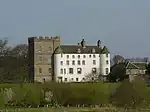
| |||
| Kimmerghame House With Terrace And Boundary Walls, Boar Statues, Garden Seat, Sundial, Gates And Gatepiers | 55°45′18″N 2°18′36″W | Category B | 2133 | Upload Photo | |||
| Sinclair's Hill, Former School | 55°44′59″N 2°17′45″W | Category B | 2134 | Upload Photo | |||
| Allanbank Courtyard, Former Steading | 55°47′03″N 2°14′01″W | Category B | 44450 | Upload Photo | |||
| Allanton, Allanton Inn | 55°46′55″N 2°12′56″W | Category C(S) | 44453 | Upload Photo | |||
| Allanton, Ardshiel | 55°46′50″N 2°12′56″W | Category C(S) | 44455 | Upload Photo | |||
| Allanton, Former Uf Church, Manse, Hearse House/Stables, Linking Outbuilding And Boundary Wall | 55°46′21″N 2°12′42″W | Category C(S) | 44459 | Upload Photo | |||
| Allanton, Holmeknowe | 55°46′57″N 2°12′56″W | Category C(S) | 44462 | Upload Photo | |||
| Allanton, South Lodge, Lydd Cottage, East Entrance To Former Blackadder Estate With Quadrants, Gatepiers, Gate And Railings | 55°46′53″N 2°12′58″W | Category B | 44465 | Upload Photo | |||
| Allanton, Fernbank (Old School House), And Baldrick Cottage | 55°46′56″N 2°12′58″W | Category C(S) | 44467 | Upload Photo | |||
| 1-4 (Inclusive Nos) Blackadder Bank Cottages | 55°45′55″N 2°12′58″W | Category C(S) | 44469 | Upload Photo | |||
| Blackadder Walled Garden With Summer House Outbuildings Gateway And Gates | 55°46′39″N 2°14′25″W | Category B | 44478 | Upload Photo | |||
| Edrom War Memorial | 55°47′25″N 2°16′09″W | Category B | 44490 | Upload Photo | |||
| Kimmerghame Mains, Farmhouse | 55°44′48″N 2°18′11″W | Category B | 44506 | Upload Photo | |||
| Nisbet Hill, Bridge | 55°44′47″N 2°19′14″W | Category B | 44509 | .jpg.webp)
| |||
| Kelloe Bridge | 55°46′23″N 2°15′46″W | Category B | 2130 | Upload Photo | |||
| Nisbet Dovecot | 55°44′55″N 2°19′33″W | Category A | 2132 | 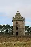
| |||
| Blackadder Bridge | 55°47′01″N 2°13′07″W | Category B | 2135 | Upload Photo | |||
| Allanton, Allanton Post Office And Rose Cottage | 55°46′57″N 2°12′59″W | Category C(S) | 44454 | Upload Photo | |||
| Allanton, Former A Brunton And Son With Outbuilding | 55°46′58″N 2°12′57″W | Category C(S) | 44457 | Upload Photo | |||
| Allanton, Former Carter's House | 55°46′56″N 2°12′56″W | Category C(S) | 44458 | Upload Photo | |||
| Allanton, Garrymore | 55°46′56″N 2°12′56″W | Category C(S) | 44460 | Upload Photo | |||
| 4 And 5 Blackadder Mount Farm Cottages With Smithy And Joiner's Workshop | 55°46′24″N 2°13′41″W | Category C(S) | 44475 | Upload Photo | |||
| Crunklaw, Steading | 55°44′44″N 2°21′03″W | Category C(S) | 44484 | Upload Photo | |||
| Kimmerghame Estate, Gardener's Cottage | 55°45′19″N 2°17′31″W | Category B | 44498 | Upload Photo | |||
| Kimmerghame Estate, 1 And 2 Kimmerghame Heugh | 55°45′34″N 2°17′13″W | Category C(S) | 44499 | Upload Photo | |||
| Kimmerghame House, Walled Garden With Greenhouses And Urns | 55°45′17″N 2°17′37″W | Category B | 44504 | Upload Photo | |||
| Stuartslaw, Steading | 55°47′26″N 2°13′45″W | Category B | 44517 | Upload Photo | |||
| West Blackadder-Cottages | 55°45′49″N 2°15′07″W | Category C(S) | 44518 | Upload Photo | |||
| Kimmerghame House, North Lodge | 55°45′22″N 2°18′12″W | Category B | 4272 | Upload Photo | |||
| Edrom Newton Farm Buildings | 55°47′23″N 2°16′33″W | Category B | 4277 | Upload Photo | |||
| Allanton Bridge | 55°47′04″N 2°13′01″W | Category B | 2136 | Upload Photo | |||
| Blackadder Mains, Cottage | 55°45′45″N 2°14′18″W | Category C(S) | 44473 | Upload Photo | |||
| Broomdykes, Steading With Stalk | 55°46′34″N 2°11′41″W | Category B | 44480 | Upload Photo | |||
| Gardener's Cottage | 55°46′42″N 2°14′22″W | Category C(S) | 44491 | Upload Photo | |||
| Kimmerghame House, Stables | 55°45′21″N 2°17′47″W | Category B | 44503 | Upload Photo | |||
| Nisbet House, Stable And Coach House | 55°45′15″N 2°19′40″W | Category A | 44511 | Upload Photo | |||
| 6 Sinclair's Hill, Old School House | 55°44′59″N 2°17′43″W | Category B | 44514 | Upload Photo | |||
| Whitelaw, Farmhouse, Stable And Outbuildings | 55°45′59″N 2°17′03″W | Category C(S) | 4276 | Upload Photo | |||
| Chirnside Bridge Paper Mill And Stalk | 55°47′59″N 2°14′20″W | Category B | 4126 | Upload Photo | |||
| Allanton, North Lodge, Woodside Cottage, East Entrance To Former Blackadder Estate With Quadrants, Gatepiers, Gate And Railings | 55°46′54″N 2°12′58″W | Category C(S) | 150 | Upload Photo | |||
| Blackadder Cottage | 55°46′48″N 2°14′16″W | Category B | 44471 | Upload Photo | |||
| Bridge To Sw Of Mungo Walls, Spanning Langton Burn | 55°45′42″N 2°18′38″W | Category C(S) | 44479 | Upload Photo | |||
| Hermitage | 55°44′35″N 2°18′46″W | Category C(S) | 44493 | Upload Photo | |||
| Kimmerghame House, Water Tower | 55°45′18″N 2°17′53″W | Category B | 44505 | Upload Photo | |||
| Mid Edrom, Steading | 55°47′46″N 2°16′31″W | Category B | 44507 | Upload Photo | |||
| Nisbet Rhodes | 55°45′33″N 2°20′20″W | Category C(S) | 44512 | Upload Photo | |||
| 7 And 8 Sinclair's Hill, With Former Smithy | 55°44′58″N 2°17′44″W | Category B | 44515 | Upload Photo | |||
| Stuartslaw, Farmhouse | 55°47′25″N 2°13′41″W | Category C(S) | 44516 | Upload Photo | |||
| Chirnside Bridge, Former Manager's House With Summer House, Boundary Walls And Steps | 55°47′56″N 2°14′22″W | Category B | 4127 | Upload Photo | |||
| Edrom, Parish Church With Graveyeard And Monuments | 55°47′44″N 2°16′36″W | Category A | 2127 | Upload Photo | |||
| Allanton, Allanbrae | 55°46′59″N 2°13′01″W | Category C(S) | 44452 | Upload Photo | |||
| Allanton, Smiddy Cottage | 55°46′50″N 2°12′55″W | Category C(S) | 44464 | Upload Photo | |||
| Bellshiel Farmhouse | 55°44′13″N 2°17′18″W | Category B | 44468 | Upload Photo | |||
| Chirnside Bridge | 55°47′57″N 2°14′16″W | Category B | 44482 | Upload Photo | |||
| Edrom, Village Hall And Former School | 55°47′38″N 2°16′25″W | Category C(S) | 44486 | Upload Photo | |||
| Kelloe Lodge, Gatepiers, Gate, Quadrants And Boundary Walls | 55°46′29″N 2°15′46″W | Category C(S) | 44496 | Upload Photo | |||
| Kimmerghame Mill | 55°45′24″N 2°18′19″W | Category B | 4274 | Upload Photo | |||
| Blackadder Mount, South Lodge Gatepiers And Gates | 55°45′48″N 2°13′44″W | Category B | 4279 | Upload Photo | |||
| Allanton, Boat House | 55°47′06″N 2°13′08″W | Category C(S) | 44451 | Upload Photo | |||
| Allanton, Sheaf House | 55°46′56″N 2°12′58″W | Category C(S) | 44463 | Upload Photo | |||
| Allanton, Southern Water Fountain | 55°46′52″N 2°12′56″W | Category B | 44466 | Upload Photo | |||
| Blackadder Bank, Farmhouse | 55°45′54″N 2°13′10″W | Category B | 44470 | Upload Photo | |||
| Blackadder Mains Steading | 55°45′51″N 2°14′27″W | Category B | 44472 | Upload Photo | |||
| Blackadder North Lodge | 55°47′13″N 2°14′37″W | Category B | 44476 | Upload Photo | |||
| Edrom House Lodge | 55°47′45″N 2°16′31″W | Category C(S) | 44487 | Upload Photo | |||
| Kimmerghame House, Ice House | 55°45′25″N 2°17′53″W | Category C(S) | 44501 | Upload Photo | |||
| Chirnside Bridge Paper Mill, Former Railway Bridge | 55°48′02″N 2°14′26″W | Category B | 179 | Upload Photo | |||
| Allanton, Greystones | 55°46′56″N 2°12′56″W | Category C(S) | 44461 | Upload Photo | |||
| Blackadder Suspension Bridge | 55°46′53″N 2°13′54″W | Category C(S) | 44477 | Upload Photo | |||
| Canal Bridge, Near Nisbet House | 55°45′04″N 2°19′47″W | Category C(S) | 44481 | Upload Photo | |||
| Crunklaw, House And Outbuilding | 55°44′43″N 2°21′02″W | Category B | 44483 | Upload Photo | |||
| Gold Nick | 55°46′49″N 2°13′22″W | Category B | 44492 | Upload Photo | |||
| Kimmerghame Estate, South Lodge And Gatepiers | 55°45′05″N 2°17′49″W | Category B | 44500 | Upload Photo | |||
| Kimmerghame House, Pedestrian Bridge | 55°45′26″N 2°17′49″W | Category B | 44502 | Upload Photo | |||
| Monument To Antoine De La Bastie | 55°48′07″N 2°18′48″W | Category B | 44508 | Upload Photo | |||
| Nisbet Hill, Mill House | 55°44′47″N 2°19′23″W | Category C(S) | 44510 | Upload Photo | |||
| Blackadder Mount Steading | 55°46′24″N 2°14′00″W | Category B | 4278 | Upload Photo | |||
| Allanton, Old Fire Station | 55°46′55″N 2°12′56″W | Category B | 4280 | Upload Photo | |||
| Edrom House With Gates And Gatepiers, Canal Bridge And Outbuildings | 55°47′47″N 2°16′46″W | Category B | 2129 | Upload Photo | |||
| Edrom Newton, Farmhouse With Boundary Walls, Gatepiers And Outbuilding | 55°47′20″N 2°16′30″W | Category B | 151 | Upload Photo |
Key
The scheme for classifying buildings in Scotland is:
- Category A: "buildings of national or international importance, either architectural or historic; or fine, little-altered examples of some particular period, style or building type."[1]
- Category B: "buildings of regional or more than local importance; or major examples of some particular period, style or building type, which may have been altered."[1]
- Category C: "buildings of local importance; lesser examples of any period, style, or building type, as originally constructed or moderately altered; and simple traditional buildings which group well with other listed buildings."[1]
In March 2016 there were 47,288 listed buildings in Scotland. Of these, 8% were Category A, and 50% were Category B, with the remaining 42% being Category C.[2]
Notes
- Sometimes known as OSGB36, the grid reference (where provided) is based on the British national grid reference system used by the Ordnance Survey.
• "Guide to National Grid". Ordnance Survey. Retrieved 12 December 2007.
• "Get-a-map". Ordnance Survey. Retrieved 17 December 2007. - Historic Environment Scotland assign a unique alphanumeric identifier to each designated site in Scotland, for listed buildings this always begins with "LB", for example "LB12345".
References
- All entries, addresses and coordinates are based on data from Historic Scotland. This data falls under the Open Government Licence
- "What is Listing?". Historic Environment Scotland. Retrieved 29 May 2018.
- Scotland's Historic Environment Audit 2016 (PDF). Historic Environment Scotland and the Built Environment Forum Scotland. pp. 15–16. Retrieved 29 May 2018.
This article is issued from Wikipedia. The text is licensed under Creative Commons - Attribution - Sharealike. Additional terms may apply for the media files.