List of listed buildings in Mertoun, Scottish Borders
List
| Name | Location | Date Listed | Grid Ref. [note 1] | Geo-coordinates | Notes | LB Number [note 2] | Image |
|---|---|---|---|---|---|---|---|
| Dovecote, Mertoun | 55°34′45″N 2°36′14″W | Category A | 15112 | _(14781947535).jpg.webp)
| |||
| Wallace Monument And Ornamental Urn, In Policies Of Bemersyde House | 55°35′10″N 2°38′58″W | Category B | 15122 | 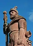
| |||
| Old Mertoun House | 55°34′47″N 2°36′16″W | Category B | 15111 |  Upload Photo | |||
| Dovecot, Dryburgh Abbey House | 55°34′31″N 2°38′56″W | Category B | 15116 | 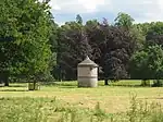
| |||
| Mertoun Bridge | 55°34′50″N 2°37′14″W | Category B | 15113 | 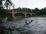
| |||
| Stirling Tower, Dryburgh | 55°34′50″N 2°39′03″W | Category B | 15125 | .jpg.webp)
| |||
| West Lodge Gateway, Gladswood | 55°36′07″N 2°39′38″W | Category B | 15127 | 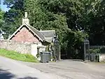
| |||
| Dryburgh, K6 Telephone Kiosk At Post Office | 55°34′50″N 2°38′58″W | Category B | 19114 | Upload Photo | |||
| Tomb of Sir Walter Scott, King James obelisk, headstone of Field Marshall Earl Haig and memorials in burial ground to the north of Dryburgh Abbey | 55°34′38″N 2°38′58″W | Category A | 15114 | 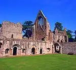
| |||
| Temple Of The Muses, Dryburgh Mains | 55°34′53″N 2°39′16″W | Category B | 15123 | .jpg.webp)
| |||
| Orchard Gate, Dryburgh | 55°34′50″N 2°38′58″W | Category B | 15124 | 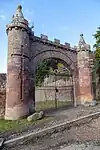
| |||
| Old Gladswood House, Gladswood Farm | 55°36′08″N 2°39′37″W | Category B | 15129 | Upload Photo | |||
| Mertoun House | 55°34′40″N 2°36′27″W | Category A | 15110 | 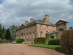
| |||
| Dryburgh Abbey House Including Sundial | 55°34′34″N 2°38′51″W | Category B | 15115 | .jpg.webp)
| |||
| Ice House, Dryburgh Abbey House | 55°34′35″N 2°39′01″W | Category B | 15118 | Upload Photo | |||
| Sundial, Bemersyde House | 55°35′30″N 2°38′54″W | Category B | 15121 | .jpg.webp)
| |||
| Gladswood | 55°36′11″N 2°39′09″W | Category B | 19714 | Upload Photo | |||
| Old Corn-Mill, Dryburgh | 55°34′34″N 2°38′45″W | Category B | 15117 | Upload Photo | |||
| Mertoun Mill | 55°34′56″N 2°37′19″W | Category C(S) | 13876 | Upload Photo | |||
| St Boswell's, Mertoun Glebe | 55°35′05″N 2°37′03″W | Category B | 49974 | Upload Photo | |||
| Dryburgh Abbey House Stables | 55°34′35″N 2°38′46″W | Category B | 19668 | Upload Photo | |||
| Mertoun Church | 55°34′43″N 2°36′41″W | Category B | 15108 | 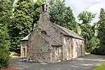
| |||
| Old Churchyard | 55°34′42″N 2°35′51″W | Category B | 15109 | Upload Photo | |||
| Bemersyde House | 55°35′31″N 2°38′55″W | Category A | 15120 | .jpg.webp) |
Key
The scheme for classifying buildings in Scotland is:
- Category A: "buildings of national or international importance, either architectural or historic; or fine, little-altered examples of some particular period, style or building type."[1]
- Category B: "buildings of regional or more than local importance; or major examples of some particular period, style or building type, which may have been altered."[1]
- Category C: "buildings of local importance; lesser examples of any period, style, or building type, as originally constructed or moderately altered; and simple traditional buildings which group well with other listed buildings."[1]
In March 2016 there were 47,288 listed buildings in Scotland. Of these, 8% were Category A, and 50% were Category B, with the remaining 42% being Category C.[2]
Notes
- Sometimes known as OSGB36, the grid reference (where provided) is based on the British national grid reference system used by the Ordnance Survey.
• "Guide to National Grid". Ordnance Survey. Retrieved 12 December 2007.
• "Get-a-map". Ordnance Survey. Retrieved 17 December 2007. - Historic Environment Scotland assign a unique alphanumeric identifier to each designated site in Scotland, for listed buildings this always begins with "LB", for example "LB12345".
References
- All entries, addresses and coordinates are based on data from Historic Scotland. This data falls under the Open Government Licence
- "What is Listing?". Historic Environment Scotland. Retrieved 29 May 2018.
- Scotland's Historic Environment Audit 2016 (PDF). Historic Environment Scotland and the Built Environment Forum Scotland. pp. 15–16. Retrieved 29 May 2018.
This article is issued from Wikipedia. The text is licensed under Creative Commons - Attribution - Sharealike. Additional terms may apply for the media files.