List of listed buildings in Dunrossness
List
| Name | Location | Date Listed | Grid Ref. [note 1] | Geo-coordinates | Notes | LB Number [note 2] | Image |
|---|---|---|---|---|---|---|---|
| Fair Isle, Aerogenerator | 59°31′17″N 1°38′28″W | Category B | 44538 | 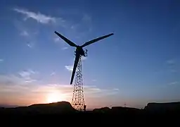
| |||
| Mail Kirk And Manse | 60°02′04″N 1°13′50″W | Category C(S) | 44544 |  Upload Photo | |||
| Bremire Crofthouse, Including Barns, Byre, Kiln, And Yard Wall | 59°56′16″N 1°18′25″W | Category C(S) | 5415 | Upload Photo | |||
| Fair Isle, Fair Isle Old Hall (Now Museum) | 59°31′03″N 1°38′34″W | Category B | 5418 | Upload Photo | |||
| Troswick Clack Mills, Including Road Bridge And Footbridges | 59°56′14″N 1°16′28″W | Category B | 5440 | Upload Photo | |||
| Sumburgh Head, Sumburgh Lighthouse, Including Ancillary Buildings, Fog Horn House, Sundial, Boundary And Retaining Walls, Gates And Gatepiers | 59°51′16″N 1°16′27″W | Category A | 5442 | 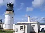
| |||
| Fair Isle, Head Of Tind, South Fair Isle Lighthouse, Including Outbuilding, Sundial, Former Toilets And Petrol Store, Fog Horn House, Boundary Walls And Gatepiers, Former Lifeboat House, Winch, And Semaphore | 59°30′50″N 1°39′08″W | Category B | 5411 | 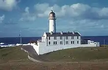
| |||
| Southvoe , Shetland Crofthouse Museum Including Byre, Barn And Kiln, Boat-Roofed Shed, Kailyard And Boundary Walls | 59°54′53″N 1°17′21″W | Category B | 5413 | 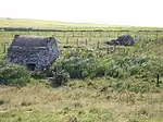
| |||
| Sandsair Pier | 60°00′25″N 1°13′14″W | Category B | 49410 | Upload Photo | |||
| Fair Isle, Fair Isle Methodist Chapel, Including Boundary Wall And Gatepiers | 59°31′03″N 1°38′32″W | Category C(S) | 44540 | 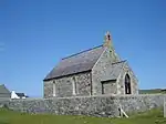
| |||
| Sumburgh House (Now Hotel), Including Terrace, Boundary Walls, And Gatepiers | 59°52′10″N 1°17′14″W | Category B | 44548 | .jpg.webp)
| |||
| Villains Crofthouse, Including Outbuildings | 60°02′15″N 1°13′54″W | Category C(S) | 44549 | Upload Photo | |||
| Sand Lodge, Including Walled Garden, Folly, Glasshouses, Conservatory, Steading And Cottage, Doocot, Sundial, Boundary Walls, Gates And Gatepiers | 60°00′22″N 1°13′06″W | Category B | 5444 | 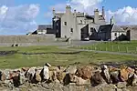
| |||
| Fair Isle, North Fair Isle Lighthouse, Including Boundary Wall, Gate And Gatepiers, Sundial, Walkway And Fog Horn House | 59°33′07″N 1°36′37″W | Category B | 5446 | 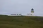
| |||
| Fair Isle, Haa Of Fair Isle, Including Garage And Boundary Walls | 59°30′58″N 1°38′34″W | Category B | 5447 | 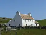
| |||
| Sumburgh Home Farm, Including Farmhouse, Steading, Kiln And Boundary Walls | 59°52′04″N 1°16′53″W | Category B | 5412 | Upload Photo | |||
| Fair Isle, Fair Isle Kirk (Church Of Scotland), Including Boundary Wall And Gatepiers | 59°31′17″N 1°38′12″W | Category C(S) | 44539 | 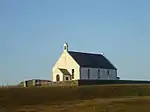
| |||
| Fair Isle, Shirva, Telephone Kiosk | 59°31′18″N 1°38′37″W | Category B | 44542 | Upload Photo | |||
| Southvoe, Burn Of Wiltrow, Southvoe Water Mills, Including Footbridges | 59°54′49″N 1°17′08″W | Category B | 5414 | Upload Photo | |||
| Brew, Dunrossness Kirk (Church Of Scotland), Including Kirkyard Wall And Gatepiers | 59°55′12″N 1°18′07″W | Category B | 5439 | Upload Photo | |||
| Sandwick Church (Church Of Scotland), Including Railings, Walls And Gatepiers | 59°59′48″N 1°13′33″W | Category B | 78 | 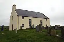
| |||
| Fair Isle, North Haven, Storehouse | 59°32′14″N 1°36′25″W | Category C(S) | 44541 | 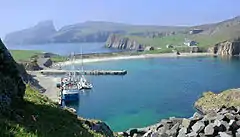
| |||
| Sandwick Manse, Including Outbuildings, Boundary And Garden Walls And Summerhouse | 59°59′58″N 1°13′51″W | Category B | 5443 | Upload Photo | |||
| Grutness, Lighthouse Store, Including Boundary Wall, Gate, And Gatepiers | 59°52′22″N 1°16′44″W | Category C(S) | 44543 | Upload Photo | |||
| Out Voe, Fish-Curing Station | 59°55′20″N 1°17′19″W | Category B | 44545 | 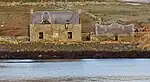
| |||
| Quendale Haa, Including Boundary Wall, And Gateway | 59°54′06″N 1°20′18″W | Category B | 44546 | 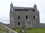
| |||
| Bigton, Bigton House, Including Walls And Gatepiers | 59°58′18″N 1°19′32″W | Category B | 5416 | Upload Photo | |||
| Quendale Mill, Including Dam, Steading, Walls, And Bridge | 59°54′09″N 1°20′19″W | Category A | 5417 | 
| |||
| Bigton, St Ninian's Church (Church Of Scotland), Including Boundary Wall And Gatepiers | 59°58′29″N 1°18′47″W | Category C(S) | 44537 | .jpg.webp) |
Key
The scheme for classifying buildings in Scotland is:
- Category A: "buildings of national or international importance, either architectural or historic; or fine, little-altered examples of some particular period, style or building type."[1]
- Category B: "buildings of regional or more than local importance; or major examples of some particular period, style or building type, which may have been altered."[1]
- Category C: "buildings of local importance; lesser examples of any period, style, or building type, as originally constructed or moderately altered; and simple traditional buildings which group well with other listed buildings."[1]
In March 2016 there were 47,288 listed buildings in Scotland. Of these, 8% were Category A, and 50% were Category B, with the remaining 42% being Category C.[2]
Notes
- Sometimes known as OSGB36, the grid reference (where provided) is based on the British national grid reference system used by the Ordnance Survey.
• "Guide to National Grid". Ordnance Survey. Retrieved 12 December 2007.
• "Get-a-map". Ordnance Survey. Retrieved 17 December 2007. - Historic Environment Scotland assign a unique alphanumeric identifier to each designated site in Scotland, for listed buildings this always begins with "LB", for example "LB12345".
References
- All entries, addresses and coordinates are based on data from Historic Scotland. This data falls under the Open Government Licence
- "What is Listing?". Historic Environment Scotland. Retrieved 29 May 2018.
- Scotland's Historic Environment Audit 2016 (PDF). Historic Environment Scotland and the Built Environment Forum Scotland. pp. 15–16. Retrieved 29 May 2018.
This article is issued from Wikipedia. The text is licensed under Creative Commons - Attribution - Sharealike. Additional terms may apply for the media files.