List of listed buildings in Tingwall, Shetland Islands
List
| Name | Location | Date Listed | Grid Ref. [note 1] | Geo-coordinates | Notes | LB Number [note 2] | Image |
|---|---|---|---|---|---|---|---|
| Lax Firth, Laxfirth House, Including Walled Garden And Gatepiers | 60°12′21″N 1°12′53″W | Category C(S) | 47293 |  Upload Photo | |||
| Scalloway, Main Street, Scalloway Meat Company | 60°08′14″N 1°16′35″W | Category C(S) | 47303 | 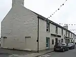
| |||
| Sound, John Clunies Ross's House, Including Bods, Cottages, Outbuildings, Walls And Slip | 60°14′03″N 1°18′35″W | Category B | 47305 | Upload Photo | |||
| Whiteness, St Ola's Kirk, Including Graveyard Wall | 60°12′34″N 1°17′28″W | Category C(S) | 18560 | Upload Photo | |||
| Binna Ness, Binna Ness House (Jackville), Including Outbuilding, Walled Garden, And Wall | 60°10′15″N 1°19′14″W | Category B | 18561 | Upload Photo | |||
| East Burra, Houss, Haa Of Houss, Including Outbuilding | 60°03′47″N 1°19′33″W | Category C(S) | 47291 | Upload Photo | |||
| Scalloway, Chapel Lane And Houl Road, Scalloway Methodist Church, Including Walls, Railings, And Gatepiers | 60°08′17″N 1°16′41″W | Category C(S) | 47297 | Upload Photo | |||
| Veensgarth, Veensgarth House, Including Garden Wall And Outbuilding | 60°10′49″N 1°13′47″W | Category C(S) | 47311 | Upload Photo | |||
| Scalloway, Main Street, Anderson's Buildings: Westmost | 60°08′14″N 1°16′34″W | Category C(S) | 43272 | Upload Photo | |||
| Scalloway, Main Street, Scalloway Church (Church Of Scotland), Including Boundary Walls And Gatepiers | 60°08′16″N 1°16′47″W | Category B | 18556 | 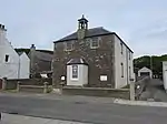
| |||
| Scalloway, Main Street, An-Teallach | 60°08′14″N 1°16′54″W | Category C(S) | 47299 | Upload Photo | |||
| Scalloway, Main Street, Anderson's Buildings: Eastmost (Post Office) | 60°08′14″N 1°16′31″W | Category C(S) | 43269 | Upload Photo | |||
| Scalloway, Main Street, Bank Building | 60°08′14″N 1°16′35″W | Category C(S) | 43273 | Upload Photo | |||
| Tingwall, St Magnus's Kirk, Mitchell's Of Westshore Burial Aisle | 60°10′33″N 1°14′47″W | Category B | 18555 | _20080820_01.jpg.webp)
| |||
| Scalloway, New Street, Old Haa Of Scalloway, Including Boundary Walls And Steps | 60°08′13″N 1°16′30″W | Category A | 18558 | Upload Photo | |||
| Weisdale, South Setter House | 60°16′27″N 1°17′01″W | Category C(S) | 18563 | Upload Photo | |||
| Scalloway, Main Street, St Clair Court | 60°08′14″N 1°16′53″W | Category C(S) | 47298 | Upload Photo | |||
| Scalloway, Main Street, Olaf View | 60°08′14″N 1°16′55″W | Category C(S) | 47300 | Upload Photo | |||
| Tingwall, St Magnus's Kirk, Including Kirkyard Walls, War Memorial, Enclosures, Gates And Gatepiers | 60°10′34″N 1°14′48″W | Category B | 18554 | Upload Photo | |||
| Girlsta, Girlsta Lime Kiln | 60°14′11″N 1°13′28″W | Category B | 47292 | Upload Photo | |||
| Scalloway, Main Street And Ladysmith Road, Norway House | 60°08′13″N 1°16′57″W | Category C(S) | 47301 | 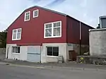
| |||
| Weisdale, Huxter, Ervhouse, Including Steading And Garden Walls | 60°14′17″N 1°17′39″W | Category C(S) | 47309 | Upload Photo | |||
| Scalloway, Main Street, Scalloway Museum | 60°08′14″N 1°16′31″W | Category C(S) | 43268 | Upload Photo | |||
| Scalloway, Main Street, Westmost Of Group, Including Anderson's Buildings (Known As The Meeting Room) | 60°08′14″N 1°16′34″W | Category C(S) | 43274 | Upload Photo | |||
| Weisdale, Mill Of Kergord (Weisdale Mill) | 60°15′37″N 1°17′18″W | Category C(S) | 18564 | Upload Photo | |||
| Girlsta, Mill Of Girlsta | 60°14′14″N 1°13′26″W | Category B | 18565 | 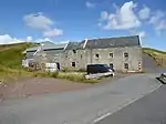
| |||
| Scalloway, Castle Road And Castle Street, Fishermans Arms | 60°08′07″N 1°16′28″W | Category C(S) | 47296 | Upload Photo | |||
| Scalloway, Main Street And Westshore, Prince Olav Slipway | 60°08′13″N 1°16′52″W | Category C(S) | 47302 | Upload Photo | |||
| West Burra, Bridge End, Church Of Scotland, Including Boundary Walls, Railings And Gates | 60°04′47″N 1°20′13″W | Category C(S) | 44602 | Upload Photo | |||
| Weisdale, Weisdale Church (Church Of Scotland) | 60°15′20″N 1°17′23″W | Category B | 18954 | Upload Photo | |||
| Scalloway, Castle Road And Castle Street, Scalloway Castle, Including Boundary Walls | 60°08′08″N 1°16′26″W | Category A | 18559 | 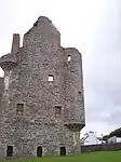
| |||
| West Burra, Duncansclate, Easthouse Croft, Including Cottages, Barn, Byres, Hen House, Pigsty, Lamb House And Skeo | 60°03′44″N 1°20′26″W | Category B | 18562 | Upload Photo | |||
| Nesbister Point, Bod Of Nesbister, Including Steps | 60°11′12″N 1°17′24″W | Category C(S) | 47294 | Upload Photo | |||
| Scalloway, New Street, The Bulwark | 60°08′09″N 1°16′31″W | Category C(S) | 47304 | Upload Photo | |||
| Veensgarth, Veensgarth Steading | 60°10′50″N 1°13′46″W | Category C(S) | 47308 | Upload Photo | |||
| Scalloway, Main Street, Anderson's Buildings: Inner Eastmost (Mowat & Co) | 60°08′14″N 1°16′32″W | Category C(S) | 43270 | Upload Photo | |||
| Scalloway, Main Street, Anderson's Buildings: Inner West | 60°08′14″N 1°16′33″W | Category B | 43271 | Upload Photo | |||
| Scalloway, Main Street, Gibblestone House, Including Boundary Walls And Gatepiers | 60°08′16″N 1°16′36″W | Category C(S) | 18557 | Upload Photo | |||
| Scalloway, Berry Road, Scalloway Hall And Library, Including Railings And Gatepiers | 60°08′19″N 1°16′36″W | Category C(S) | 47295 | Upload Photo | |||
| Tingwall Manse, Including Boundary Walls And Gatepiers | 60°10′31″N 1°14′47″W | Category C(S) | 47306 | Upload Photo | |||
| Weisdale, Kergord House, Including Glasshouse, Boundary Walls, Gates And Gatepiers | 60°16′14″N 1°17′14″W | Category C(S) | 47310 | Upload Photo |
Key
The scheme for classifying buildings in Scotland is:
- Category A: "buildings of national or international importance, either architectural or historic; or fine, little-altered examples of some particular period, style or building type."[1]
- Category B: "buildings of regional or more than local importance; or major examples of some particular period, style or building type, which may have been altered."[1]
- Category C: "buildings of local importance; lesser examples of any period, style, or building type, as originally constructed or moderately altered; and simple traditional buildings which group well with other listed buildings."[1]
In March 2016 there were 47,288 listed buildings in Scotland. Of these, 8% were Category A, and 50% were Category B, with the remaining 42% being Category C.[2]
Notes
- Sometimes known as OSGB36, the grid reference (where provided) is based on the British national grid reference system used by the Ordnance Survey.
• "Guide to National Grid". Ordnance Survey. Retrieved 12 December 2007.
• "Get-a-map". Ordnance Survey. Retrieved 17 December 2007. - Historic Environment Scotland assign a unique alphanumeric identifier to each designated site in Scotland, for listed buildings this always begins with "LB", for example "LB12345".
References
- All entries, addresses and coordinates are based on data from Historic Scotland. This data falls under the Open Government Licence
- "What is Listing?". Historic Environment Scotland. Retrieved 29 May 2018.
- Scotland's Historic Environment Audit 2016 (PDF). Historic Environment Scotland and the Built Environment Forum Scotland. pp. 15–16. Retrieved 29 May 2018.
This article is issued from Wikipedia. The text is licensed under Creative Commons - Attribution - Sharealike. Additional terms may apply for the media files.