List of listed buildings in Lerwick
List
| Name | Location | Date Listed | Grid Ref. [note 1] | Geo-coordinates | Notes | LB Number [note 2] | Image |
|---|---|---|---|---|---|---|---|
| 169-171 (Odd Nos) Commercial Street, Including Gate And Gatepiers | 60°09′16″N 1°08′39″W | Category C(S) | 43587 |  Upload Photo | |||
| 86 Commercial Street | 60°09′14″N 1°08′37″W | Category B | 43598 | Upload Photo | |||
| 106 Commercial Street, Clydesdale Bank | 60°09′16″N 1°08′37″W | Category C(S) | 43601 | 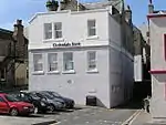
| |||
| Market Cross | 60°09′11″N 1°08′33″W | Category C(S) | 43628 | 
| |||
| Freefield, Hay's Dock And Storehouse | 60°09′30″N 1°09′00″W | Category B | 37261 | 
| |||
| 12-14 (Even Nos) Greenfield Place, St Magnus' Episcopal Church And Rectory, Including Boundary Walls | 60°09′07″N 1°08′20″W | Category B | 37270 | 
| |||
| 44-50 (Even Nos) Commercial Street, Lerwick Post Office, With Yard Wall And Gatepiers | 60°09′11″N 1°08′29″W | Category B | 37276 | 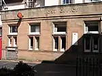
| |||
| 2-4 (Even Nos) Greenfield Place | 60°09′06″N 1°08′27″W | Category B | 37237 | Upload Photo | |||
| Hillhead And Knab Road, Annsbrae House And 1 And 2 Annsbrae Place, Including Outbuildings, Gates, Gatepiers, Boundary Walls And Railings | 60°09′05″N 1°08′31″W | Category B | 37257 | Upload Photo | |||
| 12 Charlotte Street, Lystina House, Including Boundary Walls, Gates And Gatepiers | 60°09′16″N 1°08′46″W | Category C(S) | 43579 | Upload Photo | |||
| 167 Commercial Street | 60°09′16″N 1°08′38″W | Category C(S) | 43586 | Upload Photo | |||
| 38-42 (Even Nos) Commercial Street | 60°09′11″N 1°08′28″W | Category B | 43591 | Upload Photo | |||
| 60-62 (Even Nos) Commercial Street, Anderson & Co | 60°09′11″N 1°08′33″W | Category C(S) | 43593 | Upload Photo | |||
| 66 Commercial Street | 60°09′12″N 1°08′35″W | Category C(S) | 43595 | Upload Photo | |||
| 90-92 (Even Nos) Commercial Street | 60°09′15″N 1°08′37″W | Category C(S) | 43599 | Upload Photo | |||
| 116-126 (Even Nos) Commercial Street, Charlotte Place | 60°09′18″N 1°08′37″W | Category B | 43602 | Upload Photo | |||
| Kantersted Road, Seafield, Including Steading, Boundary Walls, Gatepiers, Railings, And Gates | 60°08′32″N 1°09′45″W | Category B | 43618 | Upload Photo | |||
| King Harald Street, Islesburgh House, Including Boundary Walls, Gatepiers And Steps | 60°09′13″N 1°08′58″W | Category B | 43620 | 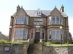
| |||
| 32-36 (Even Nos) King Harald Street, Summerside, Solheim And Carradale, Including Boundary Walls, Railings, Gates, And Gatepiers | 60°09′08″N 1°08′52″W | Category C(S) | 43621 | 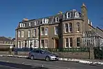
| |||
| Market Street, Garrison Theatre | 60°09′18″N 1°08′46″W | Category C(S) | 43629 | Upload Photo | |||
| Prince Alfred Street, 1 And 2 Carlton Place, Including Boundary Wall And Gate | 60°09′10″N 1°08′47″W | Category C(S) | 43632 | Upload Photo | |||
| 4-8 (Even Nos) Queen's Lane And 1 Queen's Place | 60°09′08″N 1°08′30″W | Category C(S) | 43633 | Upload Photo | |||
| 26 Church Road, Including Boundary Walls | 60°09′06″N 1°08′29″W | Category B | 37260 | Upload Photo | |||
| Twageos Road, Anderson High School (Formerly Anderson Institute), Including Wings, Boundary Walls, Railing, And Gatepiers | 60°08′59″N 1°08′12″W | Category B | 37264 | 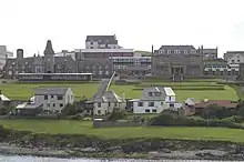
| |||
| 81-87 (Odd Nos) Commercial Street And 2 Queen's Lane, Royal Bank Of Scotland, With Boundary Wall And Gatepiers | 60°09′11″N 1°08′30″W | Category B | 37267 | _-_geograph.org.uk_-_1802873.jpg.webp)
| |||
| Esplanade, Between Grieg's Closs And Campbell's Close, The Peerie Shop | 60°09′15″N 1°08′35″W | Category C(S) | 37268 | 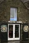
| |||
| Lower Hillhead And Union Street, St Ringan's Church (United Free Church of Scotland), Including Church Hall, Boundary Walls, And Gatepiers | 60°09′11″N 1°08′48″W | Category B | 37269 | 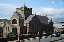
| |||
| 14 Commercial Street, The Sea Door, Including Murray's Lodberry And Macbeath's Lodberry | 60°09′10″N 1°08′18″W | Category B | 37240 | 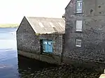
| |||
| 49 Commercial Street, Seafield House, And 1-3 (Odd Nos) Chromate Lane | 60°09′10″N 1°08′25″W | Category B | 37245 | Upload Photo | |||
| 103 And 105 Commercial Street, Including Heddle's Court | 60°09′11″N 1°08′34″W | Category B | 37253 | Upload Photo | |||
| Bell's Road And Gilbertson Road, Inches, Including Boundary Walls, Gatepiers And Pump | 60°09′13″N 1°09′18″W | Category C(S) | 43576 | Upload Photo | |||
| 25 Burgh Road, Including Boundary Walls, Railings And Gate | 60°09′15″N 1°09′03″W | Category C(S) | 43578 | 
| |||
| 107 Commercial Street And 1 Mounthooly Street | 60°09′11″N 1°08′34″W | Category C(S) | 43581 | Upload Photo | |||
| 143-151 (Odd Nos) Commercial Street, Grand Hotel | 60°09′14″N 1°08′38″W | Category B | 43584 | Upload Photo | |||
| 175 Commercial Street, Including Steps And Handrail | 60°09′17″N 1°08′39″W | Category C(S) | 43589 | Upload Photo | |||
| Esplanade And Irvine Place, Harbour Master's Office, Including Yard Wall | 60°09′13″N 1°08′34″W | Category C(S) | 43604 | Upload Photo | |||
| Grantfield, Former Ice Factory | 60°09′31″N 1°09′13″W | Category B | 43606 | Upload Photo | |||
| Hayfield Lane And Gilbertson Road, Hayfield House | 60°09′13″N 1°09′25″W | Category B | 43611 | 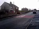
| |||
| Hillhead, Wesley (Methodist) Manse, Including Outbuilding, Boundary Walls, Railings And Gatepiers | 60°09′09″N 1°08′46″W | Category B | 43614 | Upload Photo | |||
| Knab Road, Breiwick Road, And Lover's Loan, Lerwick Old Cemetery, Including Boundary Wall And Entrance Gate | 60°09′01″N 1°08′26″W | Category C(S) | 43623 | Upload Photo | |||
| 2 Leog Lane, Leog House, Including Boundary Walls And Gatepiers | 60°09′05″N 1°08′16″W | Category C(S) | 43626 | Upload Photo | |||
| St Olaf Street, St Clement's Hall, Including Steps, Pedestals, Boundary Walls And Gatepiers | 60°09′18″N 1°08′52″W | Category C(S) | 43634 | 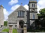
| |||
| Twageos Road And Midgarth Crescent, Bruce Hostel, With Terraces, Boundary Walls, Entrance Arch, Gates, And Gatepiers | 60°09′01″N 1°08′14″W | Category B | 43638 | 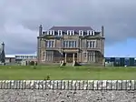
| |||
| 24-30 (Even Nos) Commercial Street, Queen's Hotel, And 2 Church Lane, Lifeboat Station, Including Sea Walls | 60°09′11″N 1°08′24″W | Category B | 37246 | 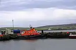
| |||
| 1 And 2 Aitken's Place | 60°09′17″N 1°08′47″W | Category C(S) | 43575 | Upload Photo | |||
| 109 Commercial Street And 2-4 (Even Nos) Mounthooly Street | 60°09′11″N 1°08′35″W | Category C(S) | 43582 | Upload Photo | |||
| 84 Commercial Street | 60°09′14″N 1°08′37″W | Category B | 43597 | Upload Photo | |||
| Grantfield, Skipidock | 60°09′31″N 1°09′18″W | Category B | 43607 | 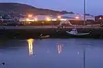
| |||
| 11 Greenfield Place, Including Boundary Walls And Gatepiers | 60°09′04″N 1°08′20″W | Category C(S) | 43608 | Upload Photo | |||
| Gressy Loan, Janet Courtney Hostel, Including Terrace | 60°08′56″N 1°08′10″W | Category B | 43609 | Upload Photo | |||
| Hillhead And Church Road, St Olaf's Hall (Formerly St Olaf's Church) | 60°09′07″N 1°08′31″W | Category C(S) | 43613 | Upload Photo | |||
| 14 Law Lane, Windhouse, Including Retaining Wall, Boundary Walls, And Outbuildings | 60°09′09″N 1°08′40″W | Category B | 43625 | Upload Photo | |||
| Gremista Road, The Bod Of Gremista | 60°10′12″N 1°09′53″W | Category B | 37258 | 
| |||
| Freefield Road, The Store | 60°24′21″N 1°07′03″W | Category B | 37275 | Upload Photo | |||
| 2-8 (Even Nos) Commercial Street, Including Sea Wall, Copeland's And Stout's Lodberries And Piers | 60°09′09″N 1°08′13″W | Category B | 37238 | 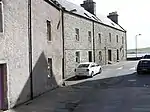
| |||
| 10 Commercial Street, Including Torrie's Lodberry And Boundary Wall | 60°09′09″N 1°08′15″W | Category B | 37239 | Upload Photo | |||
| 41-43 (Odd Nos) Commercial Street, Lochend House, Including Courtyard, Doorpiece, Retaining And Boundary Walls | 60°09′10″N 1°08′24″W | Category B | 37243 | Upload Photo | |||
| 101 Commercial Street, And 1 And 2 Gardie Lane | 60°09′11″N 1°08′33″W | Category B | 37252 | Upload Photo | |||
| 115-117 (Odd Nos) Commercial Street, Bank Of Scotland, Including Railings And Piers | 60°09′12″N 1°08′36″W | Category B | 37254 | Upload Photo | |||
| 64 Commercial Street | 60°09′12″N 1°08′34″W | Category C(S) | 43594 | Upload Photo | |||
| Esplanade, Leask's | 60°09′14″N 1°08′35″W | Category C(S) | 43605 | Upload Photo | |||
| 4 Hillhead, Including Boundary Walls And Railings | 60°09′08″N 1°08′43″W | Category C(S) | 43617 | Upload Photo | |||
| St Olaf Street And Harbour Street, Parish Church Of St Margaret (Roman Catholic), Including 87 St Olaf Street, Boundary Walls, Gate And Gatepiers | 60°09′20″N 1°08′56″W | Category C(S) | 43635 | 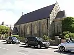
| |||
| 9 Commercial Street, The Old Manse, Including Boundary Walls And Wash-House | 60°09′08″N 1°08′13″W | Category B | 37265 | 
| |||
| 25-29 (Odd Nos) Commercial Street | 60°09′09″N 1°08′19″W | Category C(S) | 37272 | Upload Photo | |||
| 18 Commercial Street, "Steamer Store" | 60°09′10″N 1°08′19″W | Category B | 37241 | Upload Photo | |||
| Commercial Road And Harbour Street, Fort Charlotte | 60°09′19″N 1°08′43″W | Category A | 37255 | .jpg.webp)
| |||
| 113 Commercial Street | 60°09′11″N 1°08′35″W | Category C(S) | 43583 | Upload Photo | |||
| 165 Commercial Street | 60°09′16″N 1°08′38″W | Category C(S) | 43585 | Upload Photo | |||
| 12 Commercial Street And Scarfataing, Including Sea Wall | 60°09′09″N 1°08′16″W | Category C(S) | 43590 | Upload Photo | |||
| Hillhead And King Erik Street, Lerwick War Memorial | 60°09′16″N 1°08′49″W | Category B | 43612 | 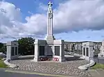
| |||
| 4-8 (Even Nos) Law Lane | 60°09′10″N 1°08′37″W | Category B | 43624 | Upload Photo | |||
| Lower Hillhead And Prince Alfred Street, 3-6 (Inclusive Nos) Carlton Place | 60°09′10″N 1°08′46″W | Category C(S) | 43627 | Upload Photo | |||
| North Ness, North Ness House, Including Boundary Walls And Gatepiers | 60°09′29″N 1°08′45″W | Category B | 37262 | Upload Photo | |||
| King Erik Street And Market Street, Police Station, County Buildings, And Sheriff Courthouse (Formerly Zetland County Buildings), Including Boundary Walls, Gatepiers, And Railings | 60°09′18″N 1°08′50″W | Category B | 37263 | 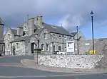
| |||
| 69-73 (Odd Nos) Commercial Street | 60°09′11″N 1°08′28″W | Category C(S) | 37273 | Upload Photo | |||
| 32 Commercial Street, Old Tolbooth | 60°09′12″N 1°08′26″W | Category B | 37247 | 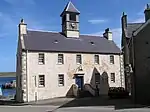
| |||
| 99 Commercial Street | 60°09′10″N 1°08′32″W | Category B | 37251 | Upload Photo | |||
| Hillhead And Charlotte Street, Lerwick Town Hall, Including Lamp Standards, Gatepiers, Boundary Walls And Railings | 60°09′16″N 1°08′47″W | Category B | 37256 | .jpg.webp)
| |||
| Quarff Church (Church Of Scotland), Including Kirkyard Wall And Gatepiers | 60°06′05″N 1°13′53″W | Category B | 12671 | .jpg.webp)
| |||
| Burgh Road, Gilbertson Park Boundary Wall, Gates, And Gatepiers | 60°09′17″N 1°09′14″W | Category B | 43577 | Upload Photo | |||
| 51-61 (Odd Nos) Commercial Street | 60°09′11″N 1°08′25″W | Category C(S) | 43580 | Upload Photo | |||
| 173 Commercial Street | 60°09′17″N 1°08′38″W | Category C(S) | 43588 | Upload Photo | |||
| 52 Commercial Street, With Gatepiers | 60°09′11″N 1°08′31″W | Category C(S) | 43592 | Upload Photo | |||
| 80-82 (Even Nos) Commercial Street | 60°09′13″N 1°08′36″W | Category B | 43596 | Upload Photo | |||
| Esplanade, Ellesmere Buildings | 60°09′12″N 1°08′33″W | Category C(S) | 43603 | Upload Photo | |||
| King Harald Street And Union Street, Islesburgh Community Centre (Formerly Lerwick Central Public School), Including Playshelters, Boundary Walls, Railings, Gates, And Gatepiers | 60°09′10″N 1°08′57″W | Category B | 43619 | 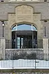
| |||
| North Ness, Gutters' Hut | 60°09′32″N 1°08′44″W | Category B | 43630 | Upload Photo | |||
| 78 St Olaf Street, Vogalee, With Boundary Walls, Railings And Gate | 60°09′16″N 1°08′52″W | Category C(S) | 43636 | Upload Photo | |||
| Sea Road, Westhall, Including Boundary And Terrace Walls | 60°08′26″N 1°09′47″W | Category C(S) | 43637 | Upload Photo | |||
| Commercial Street, 1 Hayfield Court, Including Garden Walls And Railing | 60°09′09″N 1°08′16″W | Category C(S) | 37271 | Upload Photo | |||
| Commercial Street, Telephone Kiosk | 60°09′16″N 1°08′34″W | Category B | 37277 | Upload Photo | |||
| 93-95 (Odd Nos) Commercial Street | 60°09′11″N 1°08′31″W | Category C(S) | 37249 | Upload Photo | |||
| 97 Commercial Street | 60°09′11″N 1°08′32″W | Category B | 37250 | Upload Photo | |||
| Gulberwick Church (Church Of Scotland), Including Kirkyard Wall, Gate And Gatepiers | 60°07′57″N 1°12′20″W | Category C(S) | 44555 | Upload Photo | |||
| 96 Commercial Street, Medical Hall | 60°09′15″N 1°08′37″W | Category C(S) | 43600 | Upload Photo | |||
| 1-7 (Odd Nos) Harbour Street, And 1-3 (Odd Nos) Commercial Road, Brentham Place | 60°09′23″N 1°08′42″W | Category B | 43610 | Upload Photo | |||
| 12 Hillhead, Including Boundary Walls, Railings And Gatepiers | 60°09′09″N 1°08′44″W | Category B | 43615 | Upload Photo | |||
| 2 Hillhead, Gordon Cottage, Including Boundary Walls And Railings | 60°09′07″N 1°08′43″W | Category B | 43616 | Upload Photo | |||
| North Ness, Jahara, Including Boundary Walls And Gatepiers | 60°09′28″N 1°08′45″W | Category C(S) | 43631 | Upload Photo | |||
| 31 Commercial Street, Quendale House, Including Retaining, Steps, Boundary Wall, Railing, Gatepiers And Gate | 60°09′09″N 1°08′20″W | Category B | 37266 | 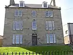
| |||
| Esplanade, Albert Building | 60°09′19″N 1°08′35″W | Category B | 37274 | 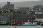
| |||
| 1-12 (Even Nos) Twageos Road, Anderson Homes | 60°09′06″N 1°08′07″W | Category C(S) | 37278 | Upload Photo | |||
| 1 Greenfield Place, St Columba's Church (Church Of Scotland), Including Gates, Retaining And Boundary Walls | 60°09′06″N 1°08′29″W | Category B | 37236 | 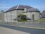
| |||
| 20 Commercial Street, The Lodberrie, Including Bains Beach Sea Wall And Steps, Craigie Stane Noost And Sea Wall | 60°09′10″N 1°08′21″W | Category A | 37242 | Upload Photo | |||
| 45 Commercial Street, Sea Winds | 60°09′10″N 1°08′24″W | Category B | 37244 | Upload Photo | |||
| 67 Commercial Street And 1 Church Lane (Formerly South Kirk Closs) | 60°09′11″N 1°08′27″W | Category B | 37248 | Upload Photo |
Key
The scheme for classifying buildings in Scotland is:
- Category A: "buildings of national or international importance, either architectural or historic; or fine, little-altered examples of some particular period, style or building type."[1]
- Category B: "buildings of regional or more than local importance; or major examples of some particular period, style or building type, which may have been altered."[1]
- Category C: "buildings of local importance; lesser examples of any period, style, or building type, as originally constructed or moderately altered; and simple traditional buildings which group well with other listed buildings."[1]
In March 2016 there were 47,288 listed buildings in Scotland. Of these, 8% were Category A, and 50% were Category B, with the remaining 42% being Category C.[2]
Notes
- Sometimes known as OSGB36, the grid reference (where provided) is based on the British national grid reference system used by the Ordnance Survey.
• "Guide to National Grid". Ordnance Survey. Retrieved 12 December 2007.
• "Get-a-map". Ordnance Survey. Retrieved 17 December 2007. - Historic Environment Scotland assign a unique alphanumeric identifier to each designated site in Scotland, for listed buildings this always begins with "LB", for example "LB12345".
References
- All entries, addresses and coordinates are based on data from Historic Scotland. This data falls under the Open Government Licence
- "What is Listing?". Historic Environment Scotland. Retrieved 29 May 2018.
- Scotland's Historic Environment Audit 2016 (PDF). Historic Environment Scotland and the Built Environment Forum Scotland. pp. 15–16. Retrieved 29 May 2018.
This article is issued from Wikipedia. The text is licensed under Creative Commons - Attribution - Sharealike. Additional terms may apply for the media files.