List of listed buildings in Unst
List
| Name | Location | Date Listed | Grid Ref. [note 1] | Geo-coordinates | Notes | LB Number [note 2] | Image |
|---|---|---|---|---|---|---|---|
| Baltasound, St John's Church (Church Of Scotland), Including Church Hall, Boundary Walls, And Gatepiers | 60°45′28″N 0°52′26″W | Category C(S) | 45290 |  Upload Photo | |||
| Clivocast, Pier Buildings, Including Slipway | 60°45′39″N 0°50′16″W | Category C(S) | 45292 | Upload Photo | |||
| Uyea, Uyea Haa, Including Terrace Wall, Outbuilding, Walled Garden, And Earl's Garden | 60°40′07″N 0°53′44″W | Category C(S) | 45298 | Upload Photo | |||
| Lund, St Olaf's Chapel, Including Kirkyard Walls And Enclosure | 60°42′57″N 0°57′46″W | Category B | 17472 | Upload Photo | |||
| Baliasta, Old Unst Manse, Including Garden Wall And Steading | 60°45′43″N 0°52′58″W | Category C(S) | 17480 | Upload Photo | |||
| Baltasound, Hagdale Horse-Mill | 60°46′13″N 0°49′34″W | Category B | 45287 | Upload Photo | |||
| Burrafirth, Muckle Flugga Lighthouse Shore Station, Including Former Accommodation Block, Cottage, Wall And Sundial, South Cottage And Steps, Store, Slipway And Derrick, Water Cistern, Garden And Boundary Walls, And Gatepiers | 60°48′43″N 0°52′27″W | Category C(S) | 45291 | Upload Photo | |||
| Houlland Steading, Including Retaining Wall And Gatepier | 60°46′22″N 0°54′24″W | Category C(S) | 45294 | Upload Photo | |||
| Uyeasound, Uyeasound Kirk (Church Of Scotland), Including Boundary Wall And Gatepiers | 60°41′19″N 0°54′08″W | Category B | 45300 | Upload Photo | |||
| Westing, Kirk Knowe Mill | 60°43′48″N 0°57′13″W | Category B | 17473 | Upload Photo | |||
| Belmont, Belmont House, Including Quadrant Links, Pavilions, Terrace Walls, Farm Cottage And Steading, Boundary Walls, And Booth | 60°41′18″N 0°58′02″W | Category A | 17474 | 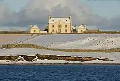
| |||
| Baliasta, Hillside Free Church And Manse, Including Outbuildings, Planticrub, Boundary And Garden Walls, And Gatepiers | 60°45′41″N 0°53′31″W | Category B | 45286 | Upload Photo | |||
| Uyea, Uyea Chapel, Including Memorial, Table Tombstone, And Graveyard Wall | 60°39′55″N 0°53′20″W | Category B | 17471 | Upload Photo | |||
| Muness, Muness Castle, Including Boundary Wall | 60°41′19″N 0°50′57″W | Category A | 17476 | 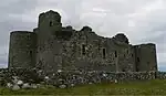
| |||
| Norwick, The Banks, Including Cottage, Outbuilding, Ruin, Boundary And Sea Walls | 60°48′38″N 0°48′16″W | Category C(S) | 45295 | Upload Photo | |||
| Baltasound, Oredaal House, Including Outbuilding And Garden Wall | 60°45′06″N 0°50′35″W | Category C(S) | 45288 | Upload Photo | |||
| Baltasound, Oredale Steading, Including Threshing Mill, Pigsty, Lade, Stackyard, And Boundary Walls | 60°45′01″N 0°50′27″W | Category B | 45289 | Upload Photo | |||
| Haroldswick, The Hamars, Including Steading, And Garden And Boundary Walls | 60°47′19″N 0°49′45″W | Category B | 45293 | Upload Photo | |||
| Papil, Valsgarth, Including Outbuildings And Walls | 60°47′37″N 0°48′59″W | Category B | 45296 | Upload Photo | |||
| Uyeasound, Pierfront Buildings And Shop | 60°41′19″N 0°55′03″W | Category C(S) | 45299 | Upload Photo | |||
| Uyeasound, Greenwell's Booth | 60°41′19″N 0°55′04″W | Category C(S) | 17475 | 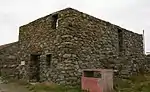
| |||
| Skaw, Boat-Roofed Shed | 60°49′30″N 0°47′28″W | Category C(S) | 45297 | Upload Photo | |||
| Baliasta, Old Unst Kirk (Church Of Scotland), Including Memorial Enclosures, Kirkyard Wall And Gatepiers | 60°45′53″N 0°53′45″W | Category C(S) | 17477 | 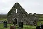
| |||
| Baltasound, Buness House, Including Terrace Wall, Garden And Boundary Walls, Gates And Gatepiers, Former Boat House, Stable, Coach House, Noost And Pier | 60°45′33″N 0°50′54″W | Category B | 17478 | Upload Photo | |||
| Muckle Flugga, North Unst Lighthouse, Including Fog Horn House, Boundary Wall, Steps, And Outbuilding | 60°51′19″N 0°53′07″W | Category A | 17479 | 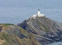 |
Key
The scheme for classifying buildings in Scotland is:
- Category A: "buildings of national or international importance, either architectural or historic; or fine, little-altered examples of some particular period, style or building type."[1]
- Category B: "buildings of regional or more than local importance; or major examples of some particular period, style or building type, which may have been altered."[1]
- Category C: "buildings of local importance; lesser examples of any period, style, or building type, as originally constructed or moderately altered; and simple traditional buildings which group well with other listed buildings."[1]
In March 2016 there were 47,288 listed buildings in Scotland. Of these, 8% were Category A, and 50% were Category B, with the remaining 42% being Category C.[2]
Notes
- Sometimes known as OSGB36, the grid reference (where provided) is based on the British national grid reference system used by the Ordnance Survey.
• "Guide to National Grid". Ordnance Survey. Retrieved 12 December 2007.
• "Get-a-map". Ordnance Survey. Retrieved 17 December 2007. - Historic Environment Scotland assign a unique alphanumeric identifier to each designated site in Scotland, for listed buildings this always begins with "LB", for example "LB12345".
References
- All entries, addresses and coordinates are based on data from Historic Scotland. This data falls under the Open Government Licence
- "What is Listing?". Historic Environment Scotland. Retrieved 29 May 2018.
- Scotland's Historic Environment Audit 2016 (PDF). Historic Environment Scotland and the Built Environment Forum Scotland. pp. 15–16. Retrieved 29 May 2018.
This article is issued from Wikipedia. The text is licensed under Creative Commons - Attribution - Sharealike. Additional terms may apply for the media files.