Montigny-sur-Avre
Montigny-sur-Avre (French pronunciation: [mɔ̃tiɲi syʁ avʁ], literally Montigny on Avre) is a commune in the Eure-et-Loir department in northern France.
Montigny-sur-Avre | |
|---|---|
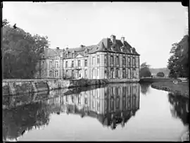 The chateau in Montigny-sur-Avre | |
Location of Montigny-sur-Avre | |
 Montigny-sur-Avre  Montigny-sur-Avre | |
| Coordinates: 48°43′49″N 1°01′23″E | |
| Country | France |
| Region | Centre-Val de Loire |
| Department | Eure-et-Loir |
| Arrondissement | Dreux |
| Canton | Saint-Lubin-des-Joncherets |
| Government | |
| • Mayor (2020–2026) | Richard Boucherie[1] |
| Area 1 | 7.26 km2 (2.80 sq mi) |
| Population | 252 |
| • Density | 35/km2 (90/sq mi) |
| Time zone | UTC+01:00 (CET) |
| • Summer (DST) | UTC+02:00 (CEST) |
| INSEE/Postal code | 28263 /28270 |
| Elevation | 135–183 m (443–600 ft) |
| 1 French Land Register data, which excludes lakes, ponds, glaciers > 1 km2 (0.386 sq mi or 247 acres) and river estuaries. | |
Population
| Year | Pop. | ±% |
|---|---|---|
| 1962 | 167 | — |
| 1968 | 219 | +31.1% |
| 1975 | 205 | −6.4% |
| 1982 | 225 | +9.8% |
| 1990 | 276 | +22.7% |
| 1999 | 275 | −0.4% |
| 2008 | 255 | −7.3% |
References
- "Répertoire national des élus: les maires". data.gouv.fr, Plateforme ouverte des données publiques françaises (in French). 2 December 2020.
- "Populations légales 2020". The National Institute of Statistics and Economic Studies. 29 December 2022.
Wikimedia Commons has media related to Montigny-sur-Avre.
FRancois Laval
This article is issued from Wikipedia. The text is licensed under Creative Commons - Attribution - Sharealike. Additional terms may apply for the media files.