Sorel-Moussel
Sorel-Moussel (French pronunciation: [sɔʁɛl musɛl]) is a commune in the Eure-et-Loir department in northern France.
Sorel-Moussel | |
|---|---|
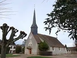 Saint-Roch church in Sorrel-Moussel | |
Location of Sorel-Moussel | |
 Sorel-Moussel  Sorel-Moussel | |
| Coordinates: 48°50′31″N 1°22′59″E | |
| Country | France |
| Region | Centre-Val de Loire |
| Department | Eure-et-Loir |
| Arrondissement | Dreux |
| Canton | Anet |
| Intercommunality | CA Pays de Dreux |
| Government | |
| • Mayor (2020–2026) | Gilbert Galland[1] |
| Area 1 | 12.8 km2 (4.9 sq mi) |
| Population | 1,740 |
| • Density | 140/km2 (350/sq mi) |
| Time zone | UTC+01:00 (CET) |
| • Summer (DST) | UTC+02:00 (CEST) |
| INSEE/Postal code | 28377 /28260 |
| Elevation | 64–137 m (210–449 ft) (avg. 90 m or 300 ft) |
| 1 French Land Register data, which excludes lakes, ponds, glaciers > 1 km2 (0.386 sq mi or 247 acres) and river estuaries. | |
It holds an important archaeological site known as Fort-Harrouard (fr), a Neolithic village first studied at the turn of the 20th century by abbé Philippe.
The medieval remains of Château de Sorel, are located nearby.
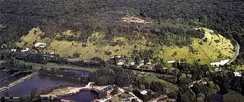 Fort Harrouard (fr)
-Mousterian_bowl.JPG.webp) Ladle made from a bison acetabulum, i.e. hip joint cavity in the iliac bone, found in Fort-Harrouard
Ladle made from a bison acetabulum, i.e. hip joint cavity in the iliac bone, found in Fort-Harrouard
Population
| Year | Pop. | ±% |
|---|---|---|
| 1962 | 796 | — |
| 1968 | 822 | +3.3% |
| 1975 | 894 | +8.8% |
| 1982 | 1,011 | +13.1% |
| 1990 | 1,317 | +30.3% |
| 1999 | 1,479 | +12.3% |
| 2008 | 1,802 | +21.8% |
References
- "Répertoire national des élus: les maires" (in French). data.gouv.fr, Plateforme ouverte des données publiques françaises. 4 May 2022.
- "Populations légales 2020". The National Institute of Statistics and Economic Studies. 29 December 2022.
Wikimedia Commons has media related to Sorel-Moussel.
This article is issued from Wikipedia. The text is licensed under Creative Commons - Attribution - Sharealike. Additional terms may apply for the media files.