National Register of Historic Places listings in Banks County, Georgia
This is a list of properties and districts in Banks County, Georgia that are listed on the National Register of Historic Places (NRHP).
This National Park Service list is complete through NPS recent listings posted October 20, 2023.[1]

Current listings
| [2] | Name on the Register | Image | Date listed[3] | Location | City or town | Description |
|---|---|---|---|---|---|---|
| 1 | Banks County Courthouse | .jpg.webp) Banks County Courthouse |
September 18, 1980 (#80000969) |
Off U.S. 441 34°20′05″N 83°29′56″W |
Homer | |
| 2 | Banks County Jail | 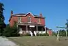 Banks County Jail |
July 26, 1982 (#82002382) |
Silver Shoals Rd. 34°20′06″N 83°29′20″W |
Homer | |
| 3 | Brooks Family Farm | 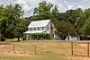 Brooks Family Farm |
July 23, 2013 (#13000529) |
584 Silver Shoals Rd. 34°22′14″N 83°33′14″W |
Lula | |
| 4 | William Chambers House | .JPG.webp) William Chambers House |
November 7, 1996 (#96001305) |
GA 51, approximately 1 mi. W of jct. with GA 63 34°22′15″N 83°25′13″W |
Homer | |
| 5 | Fort Hollingsworth-White House | .JPG.webp) Fort Hollingsworth-White House |
August 6, 1998 (#19980806) |
Wynn Lake Rd., 2 mi. SE of Hollingsworth 34°25′35″N 83°32′02″W |
Hollingsworth | |
| 6 | Gillsville Historic District | 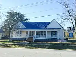 Gillsville Historic District |
August 30, 1985 (#85001933) |
GA 52 34°18′38″N 83°38′20″W |
Gillsville | |
| 7 | Hebron Church, Cemetery, and Academy | .JPG.webp) Hebron Church, Cemetery, and Academy |
September 12, 1985 (#85002176) |
Hebron Circle 34°17′12″N 83°21′53″W |
Commerce | |
| 8 | Homer Historic District | .JPG.webp) Homer Historic District |
December 3, 1985 (#85003110) |
Along Main St. and Silver Shoals Rd. 34°19′59″N 83°29′52″W |
Homer | |
| 9 | Kesler Covered Bridge | June 18, 1975 (#75000571) |
10 mi. N of Homer on County Line Rd. over Middle Fork Broad River 34°25′27″N 83°23′16″W |
Homer | Destroyed in 1978 | |
| 10 | Maysville Historic District |  Maysville Historic District |
September 12, 1985 (#85002203) |
Along E. Main, W. Main and Homer Sts. 34°15′17″N 83°33′48″W |
Maysville | |
| 11 | Mount Pleasant Historic District | .JPG.webp) Mount Pleasant Historic District |
November 7, 1996 (#96001306) |
Jct. of GA 51 and Damascus Road 34°21′53″N 83°26′33″W |
Homer | |
| 12 | Nails Creek Historic District | 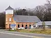 Nails Creek Historic District |
November 7, 1996 (#96001307) |
Jct. of GA 51 and GA 63 34°22′00″N 83°24′02″W |
Homer | |
| 13 | New Salem Covered Bridge | June 10, 1975 (#75000570) |
6 mi. N of Commerce on SR S992 over Grove Creek 34°15′30″N 83°25′20″W |
Commerce | Collapsed | |
| 14 | Turk Family Farm | January 8, 2003 (#03001365) |
534 Carson Segars Rd. 34°17′37″N 83°32′43″W |
Maysville |
References
- National Park Service, United States Department of the Interior, "National Register of Historic Places: Weekly List Actions", retrieved October 20, 2023.
- Numbers represent an alphabetical ordering by significant words. Various colorings, defined here, differentiate National Historic Landmarks and historic districts from other NRHP buildings, structures, sites or objects.
- The eight-digit number below each date is the number assigned to each location in the National Register Information System database, which can be viewed by clicking the number.
Wikimedia Commons has media related to National Register of Historic Places in Banks County, Georgia.
| Topics | |
|---|---|
| Lists by state |
|
| Lists by insular areas | |
| Lists by associated state | |
| Other areas | |
| Related | |
This article is issued from Wikipedia. The text is licensed under Creative Commons - Attribution - Sharealike. Additional terms may apply for the media files.