National Register of Historic Places listings in Habersham County, Georgia
This is a list of properties and districts in Habersham County, Georgia that are listed on the National Register of Historic Places (NRHP).
This National Park Service list is complete through NPS recent listings posted October 20, 2023.[1]

Current listings
| [2] | Name on the Register | Image | Date listed[3] | Location | City or town | Description |
|---|---|---|---|---|---|---|
| 1 | Acoa | June 22, 1982 (#82002446) |
Mathis Rd. 34°39′09″N 83°28′16″W |
Hollywood | ||
| 2 | Henry Asbury House | 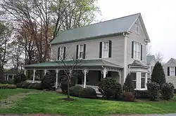 Henry Asbury House |
August 18, 1982 (#82002425) |
211 E. Waters St. 34°37′01″N 83°31′26″W |
Clarkesville | |
| 3 | Baron-York Building | 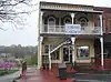 Baron-York Building |
August 18, 1982 (#82002426) |
714 N. Washington St. 34°36′56″N 83°31′34″W |
Clarkesville | |
| 4 | Chenocetah Fire Tower | 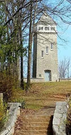 Chenocetah Fire Tower |
June 11, 1984 (#84001110) |
Chenocetah Mountain 34°30′08″N 83°30′25″W |
Cornelia | |
| 5 | Church Furniture Store | August 18, 1982 (#82002427) |
N. Washington St. 34°36′53″N 83°31′32″W |
Clarkesville | North corner of Washington and Green | |
| 6 | Clarkesville Downtown Square Historic District | November 18, 2021 (#100006669) |
Along Washington St. (US 441/23), roughly bounded by Jefferson, Morgan, Madison, Water, Monroe, and Grant Sts. 34°36′53″N 83°31′32″W |
Clarkesville | ||
| 7 | Clarkesville Garage | August 18, 1982 (#82002429) |
304 N. Washington St. 34°36′52″N 83°31′32″W |
Clarkesville | SE corner of Washington and Green | |
| 8 | Cornelia Commercial Historic District | January 3, 2022 (#100007277) |
Centered around intersection of Main and Irvin Sts. 34°30′41″N 83°31′38″W |
Cornelia | ||
| 9 | Cornelius Church House | August 18, 1982 (#82002428) |
304 N. Washington St. 34°36′53″N 83°31′30″W |
Clarkesville | ||
| 10 | Cornelia Community House | 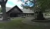 Cornelia Community House |
June 21, 1982 (#82002445) |
U.S. 123 at LaVista Lane 34°30′47″N 83°31′08″W |
Cornelia | |
| 11 | Daes Chapel Methodist Church | August 18, 1982 (#82002430) |
N. Washington St. 34°36′56″N 83°31′41″W |
Clarkesville | ||
| 12 | Demorest Commercial Historic District | October 16, 1989 (#89001713) |
Georgia St. and Central Ave. 34°33′54″N 83°32′43″W |
Demorest | ||
| 13 | Demorest Women's Club | 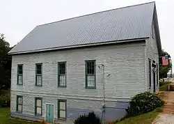 Demorest Women's Club |
December 30, 2008 (#08001247) |
1035 Central Ave. 34°33′59″N 83°32′39″W |
Demorest | |
| 14 | Furr-Lambert House | 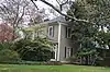 Furr-Lambert House |
August 18, 1982 (#82002431) |
223 Grant St. 34°37′06″N 83°31′27″W |
Clarkesville | |
| 15 | Glen-Ella Springs Hotel | 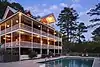 Glen-Ella Springs Hotel |
January 4, 1990 (#89002270) |
SW of Tallulah Falls on Co. Rd. 218 34°43′12″N 83°26′54″W |
Turnerville | |
| 16 | Grace Church | %252C_HABERSHAM_COUNTY.jpg.webp) Grace Church |
February 15, 1980 (#80001087) |
Wilson and Greene Sts. 34°36′58″N 83°31′24″W |
Clarkesville | |
| 17 | Griggs-Erwin House | 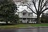 Griggs-Erwin House |
August 18, 1982 (#82002432) |
Bridge St. 34°37′02″N 83°31′37″W |
Clarkesville | |
| 18 | Haywood English Family Log House | 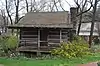 Haywood English Family Log House |
December 19, 1991 (#91001852) |
GA 115 W of jct. with Habersham Rd. 34°36′25″N 83°34′26″W |
Clarkesville | |
| 19 | A. P. Hill House | August 18, 1982 (#82002433) |
N. Washington St. 34°36′48″N 83°31′30″W |
Clarkesville | ||
| 20 | Irvin General Merchandise Store | July 26, 1984 (#84001113) |
Irvin St. 34°30′40″N 83°31′40″W |
Cornelia | ||
| 21 | Jackson Building | 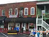 Jackson Building |
August 18, 1982 (#82002434) |
710 N. Washington St. 34°36′56″N 83°31′33″W |
Clarkesville | |
| 22 | Jackson Pharmacy | 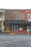 Jackson Pharmacy |
August 18, 1982 (#82002435) |
712 N. Washington St. 34°36′56″N 83°31′34″W |
Clarkesville | |
| 23 | Lawton Place | January 8, 2009 (#08001282) |
136 7th St. 34°31′01″N 83°29′58″W |
Mount Airy | ||
| 24 | J. A. Lewis House | 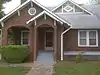 J. A. Lewis House |
August 18, 1982 (#82002436) |
N. Washington St. 34°36′48″N 83°31′27″W |
Clarkesville | |
| 25 | Loudermilk Boarding House | 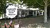 Loudermilk Boarding House |
February 9, 2001 (#01000079) |
271 Foreacre St. 34°30′42″N 83°31′28″W |
Cornelia | |
| 26 | Market Building | August 18, 1982 (#82002437) |
N. Washington St. 34°36′56″N 83°31′41″W |
Clarkesville | ||
| 27 | Mauldin House | 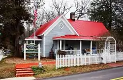 Mauldin House |
August 18, 1982 (#82002438) |
102 E. Water St. 34°36′56″N 83°31′31″W |
Clarkesville | |
| 28 | Robert McMillan House | August 18, 1982 (#82002439) |
Allen Lane 34°36′20″N 83°31′08″W |
Clarkesville | ||
| 29 | McMillan-Garrison House | August 18, 1982 (#82002440) |
403 S. Washington St. 34°36′16″N 83°31′11″W |
Clarkesville | ||
| 30 | Olgetree Farm | July 9, 1997 (#97000753) |
Jct. of Pea Ridge Rd. and Paradise Park Rd. 34°32′21″N 83°35′44″W |
View | ||
| 31 | Porter-York House | 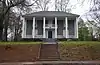 Porter-York House |
August 18, 1982 (#82002441) |
Bridge St. 34°37′03″N 83°31′38″W |
Clarkesville | |
| 32 | Pyle-Davis House | 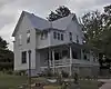 Pyle-Davis House |
June 23, 2003 (#03000537) |
202 Massachusetts Bvd. 34°33′53″N 83°32′34″W |
Demorest | |
| 33 | Reeves Building | August 18, 1982 (#82002442) |
N. Washington St. 34°36′53″N 83°31′37″W |
Clarkesville | ||
| 34 | South Washington Street Historic District | August 18, 1982 (#82002443) |
S. Washington St. between Laurel Dr. and Spring St. 34°36′26″N 83°31′17″W |
Clarkesville | ||
| 35 | Tallulah Falls School | 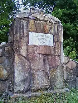 Tallulah Falls School |
January 30, 1992 (#91002026) |
Jct. of US 441 and Tallulah School Rd. 34°43′54″N 83°23′36″W |
Tallulah Falls | |
| 36 | Washington-Jefferson Street Historic District | August 18, 1982 (#82002444) |
Washington, Jefferson, and Wilson Sts. between Green St. and Laurel Dr. 34°36′49″N 83°31′21″W |
Clarkesville | ||
| 37 | Woodlands and Blythewood | December 30, 1975 (#75002121) |
3 mi. N of Clarkesville off U.S. 441 34°39′00″N 83°29′54″W |
Clarkesville |
References
- National Park Service, United States Department of the Interior, "National Register of Historic Places: Weekly List Actions", retrieved October 20, 2023.
- Numbers represent an alphabetical ordering by significant words. Various colorings, defined here, differentiate National Historic Landmarks and historic districts from other NRHP buildings, structures, sites or objects.
- The eight-digit number below each date is the number assigned to each location in the National Register Information System database, which can be viewed by clicking the number.
Wikimedia Commons has media related to National Register of Historic Places in Habersham County, Georgia.
| Topics | |
|---|---|
| Lists by state |
|
| Lists by insular areas | |
| Lists by associated state | |
| Other areas | |
| Related | |
This article is issued from Wikipedia. The text is licensed under Creative Commons - Attribution - Sharealike. Additional terms may apply for the media files.