North-West Frontier Province
The North-West Frontier Province,[lower-alpha 1] known commonly as the NWFP, was a province of British India from 1901 to 1947, of the Dominion of Pakistan from 1947 to 1955, and of the Islamic Republic of Pakistan from 1970 to 2010. It was established on 9 November 1901 from the north-western districts of the British Punjab, during the British Raj.[3] Upon independence, the province became a part of Pakistan following a referendum in 1947. It was merged into West Pakistan in 1955, but was re-established in 1970. The province was dissolved on 19 April 2010 and redesignated as Khyber Pakhtunkhwa, following the passing of the eighteenth amendment to the constitution of Pakistan.
| North-West Frontier Province شمال مغربی سرحدی صوبہ شمال لویدیځ سرحدي ولایت | |||||||||||||||||||||||
|---|---|---|---|---|---|---|---|---|---|---|---|---|---|---|---|---|---|---|---|---|---|---|---|
| Province of British India (1901–1947) Pakistan (1947–1955; 1970–2010) | |||||||||||||||||||||||
| 1901–1955; 1970–2010 | |||||||||||||||||||||||
 Coat of arms
| |||||||||||||||||||||||
 1901–1947 1947–1955 1970–2010 Location within Pakistan | |||||||||||||||||||||||
| Capital | Peshawar | ||||||||||||||||||||||
| Demonym | Sarhadi(s) | ||||||||||||||||||||||
| Area | |||||||||||||||||||||||
• 1901 | 100,142[1][2] km2 (38,665 sq mi) | ||||||||||||||||||||||
| Population | |||||||||||||||||||||||
• 1901 | 2,041,534 | ||||||||||||||||||||||
| History | |||||||||||||||||||||||
| History | |||||||||||||||||||||||
| 9 November 1901 | |||||||||||||||||||||||
| 14 August 1947 | |||||||||||||||||||||||
| 14 October 1955 | |||||||||||||||||||||||
| 1 July 1970 | |||||||||||||||||||||||
| 19 April 2010 | |||||||||||||||||||||||
| |||||||||||||||||||||||
| Today part of | Pakistan · Khyber Pakhtunkhwa | ||||||||||||||||||||||

_map.gif)

 |
| This article is part of the series |
| Former administrative units of Pakistan |
|---|
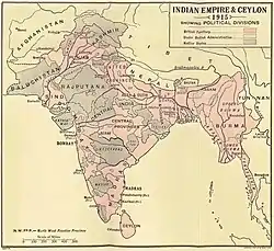
The province covered an area of 70,709 km2 (27,301 sq mi), including much of the current Khyber Pakhtunkhwa province but excluding the Federally Administered Tribal Areas and the former princely states of Amb, Chitral, Dir, Phulra and Swat. Its capital was the city of Peshawar, and the province was composed of six divisions (Bannu, Dera Ismail Khan, Hazara, Kohat, Mardan, and Peshawar Division; Malakand was later added as the seventh division). Until 1947, the province was bordered by five princely states to the north, the minor states of the Gilgit Agency to the northeast, the province of West Punjab to the east and the province of Balochistan to the south. The Kingdom of Afghanistan lay to the northwest, with the Federally Administered Tribal Areas forming a buffer zone between the two.
History
Formation
The northwestern frontier areas were annexed by the East India Company after the Second Sikh War (1848–49). The territories thenceforth formed a part of Punjab until the province, then known as North West Frontier Province, was created in 1901 from the north-western districts of the Punjab Province.[4] This region, along with the 'Frontier Tribal Areas', acted as a buffer zone with Afghanistan.
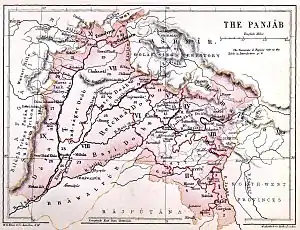 The Punjab in 1880 (included areas of the later North-West Frontier Province)
.jpg.webp) Map of the North-West Frontier Province and Kashmir from The Imperial Gazetteer of India (1907-1909)
Map of the North-West Frontier Province and Kashmir from The Imperial Gazetteer of India (1907-1909)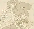 Map of the North-West Frontier Province and neighbouring regions (National Geographic, 1946)
Inside Pakistan
Before the Partition of India, the 1947 North-West Frontier Province referendum was held in July 1947 to decide the future of NWFP, in which the people of the province decided in favor of joining Pakistan. However, the then Chief Minister Dr Khan Sahib, along with his brother Bacha Khan and the Khudai Khidmatgars, boycotted the referendum, citing that it did not have the options of the NWFP becoming independent or joining Afghanistan.[5][6]
As a separate province, the NWFP lasted until 1955 when it was merged into the new province of West Pakistan, under the One Unit policy announced by Prime Minister Chaudhry Mohammad Ali. It was recreated after the dissolution of the One Unit system and lasted under its old nomenclature until April 2010, when it was renamed as the 'Khyber Pakhtunkhwa' province.
Government
The offices of Governor and Chief Minister of the North-West Frontier Province lasted until 14 October 1955.
| Tenure | Governors of the North-West Frontier Province[7] |
|---|---|
| 14 August 1947 – 8 April 1948 | Sir George Cunningham |
| 8 April 1948 – 16 July 1949 | Sir Ambrose Dundas Flux Dundas |
| 16 July 1949 – 14 January 1950 | Sahibzada Mohammad Kursheed |
| 14 January 1950 – 21 February 1950 | Mohammad Ibrahim Khan Jhagra (acting) |
| 21 February 1950 – 23 November 1951 | Ismail Ibrahim Chundrigar |
| 24 November 1951 – 17 November 1954 | Khwaja Shahabuddin |
| 17 November 1954 – 14 October 1955 | Qurban Ali Khan |
| 14 October 1955 | North-West Frontier Province dissolved |
| Tenure | Chief Ministers of the North-West Frontier Province[7] | Political party |
|---|---|---|
| 1 April 1937 – 7 September 1937 | Sir Sahibzada Abdul Qayyum Khan | Non-party government nominee |
| 7 September 1937 – 10 November 1939 | Khan Abdul Jabbar Khan (1st time) | Indian National Congress |
| 10 November 1939 – 25 May 1943 | Governor's rule | |
| 25 May 1943 – 16 March 1945 | Sardar Aurangzeb Khan | Muslim League |
| 16 March 1945 – 22 August 1947 | Khan Abdul Jabbar Khan (2nd time) | Indian National Congress |
| 14 August 1947 | Independence of Pakistan | |
| 23 August 1947 – 23 April 1953 | Abdul Qayyum Khan Kashmiri | Pakistan Muslim League |
| 23 April 1953 – 18 July 1955 | Sardar Abdur Rashid Khan | |
| 19 July 1955 – 14 October 1955 | Sardar Bahadur Khan | |
Demographics
| Year | Pop. | ±% |
|---|---|---|
| 1855 | 1,144,047 | — |
| 1868 | 1,339,566 | +17.1% |
| 1881 | 1,575,943 | +17.6% |
| 1891 | 1,857,519 | +17.9% |
| 1901 | 2,041,534 | +9.9% |
| 1911 | 2,196,933 | +7.6% |
| 1921 | 2,251,340 | +2.5% |
| 1931 | 2,425,076 | +7.7% |
| 1941 | 3,038,067 | +25.3% |
| Source: Census of India [8]: 30 [9]: 345–346 [10][11] | ||
Historical population, language, and religious counts in North-West Frontier Province were enumerated in all districts (Hazara, Mardan, Peshawar, Kohat, Bannu, and Dera Ismail Khan), detailed in the population, language, and religious tables above and below. Separate population counts were taken in the Agencies and Tribal Areas, as detailed on the respective article page.
At independence, there was a clear Muslim Pashtun and Hindkowan majority in the North-West Frontier Province, although there were also significant Hindu and Sikh Pashtun, Hindkowan and Punjabi minorities scattered across the province.
Language
The languages of the North-West Frontier Province included Pashto, Hindko, Kohistani and others, although most of the population spoke either Pashto or Lahnda/Western Punjabi (primarily Hindko and Saraiki). Prior to the arrival of the British, the official language, for governmental uses and such, was Persian.
| Mother Tongue |
1931[10]: 357–359 | |
|---|---|---|
| Population | Percentage | |
| Pashto | 1,279,471 | 52.76% |
| Western Punjabi (Lahnda)[lower-alpha 2] |
1,034,874 | 42.67% |
| Standard Punjabi | 68,031 | 2.81% |
| Hindustani | 19,221 | 0.79% |
| English | 7,852 | 0.32% |
| Persian | 6,030 | 0.25% |
| Nepali | 5,140 | 0.21% |
| Kashmiri | 1,796 | 0.07% |
| Gujari | 596 | 0.02% |
| Kohistani | 377 | 0.02% |
| Turkish | 62 | 0.003% |
| Arabic | 24 | 0.001% |
| Welsh | 19 | 0.001% |
| Portuguese | 14 | 0.001% |
| French | 9 | 0.0004% |
| Chinese | 5 | 0.0002% |
| German | 3 | 0.0001% |
| Greek | 2 | 0.0001% |
| Scotch | 1 | 0% |
| Irish | 1 | 0% |
| Spanish | 1 | 0% |
| Dutch | 1 | 0% |
| Japanese | 1 | 0% |
| Other Indo-Aryan or Dravidian languages |
1,545 | 0.06% |
| Total | 2,425,076 | 100% |
Districts
| District | Pashto | Western Punjabi (Lahnda)[lower-alpha 2] |
Standard Punjabi | Hindustani | English | Others | Total | |||||||
|---|---|---|---|---|---|---|---|---|---|---|---|---|---|---|
| Pop. | % | Pop. | % | Pop. | % | Pop. | % | Pop. | % | Pop. | % | Pop. | % | |
| Peshawar District | 781,773 | 80.24% | 127,189 | 13.05% | 40,805 | 4.19% | 11,798 | 1.21% | 5,864 | 0.6% | 6,892 | 0.71% | 974,321 | 100% |
| Hazara District | 29,375 | 4.38% | 625,268 | 93.31% | 5,436 | 0.81% | 4,113 | 0.61% | 257 | 0.04% | 5,668 | 0.85% | 670,117 | 100% |
| Dera Ismail Khan District | 53,643 | 19.57% | 213,115 | 77.76% | 4,446 | 1.62% | 419 | 0.15% | 336 | 0.12% | 2,105 | 0.77% | 274,064 | 100% |
| Bannu District | 228,381 | 84.49% | 33,547 | 12.41% | 6,267 | 2.32% | 1,181 | 0.44% | 556 | 0.21% | 369 | 0.14% | 270,301 | 100% |
| Kohat District | 186,299 | 78.85% | 35,755 | 15.13% | 11,077 | 4.69% | 1,710 | 0.72% | 839 | 0.36% | 593 | 0.25% | 236,273 | 100% |
| Total | 1,279,471 | 52.76% | 1,034,874 | 42.67% | 68,031 | 2.81% | 19,221 | 0.79% | 7,852 | 0.32% | 15,627 | 0.64% | 2,425,076 | 100% |
Religion
Religion in North–West Frontier Province (1941)[11]: 22
Religious counts below is for the entirety of NWFP (Hazara, Mardan, Peshawar, Kohat, Bannu, and Dera Ismail Khan). The Agencies and Tribal Areas constituted a separate administrative division where religious composition was not enumerated, except at small Trans-Frontier Posts in the region.
| Religious group |
1881[8]: 95 | 1891[8]: 95 | 1901[8]: 95 | 1911[8]: 307–308 | 1921[9]: 345–346 | 1931[10]: 373–375 | 1941[11]: 22 | |||||||
|---|---|---|---|---|---|---|---|---|---|---|---|---|---|---|
| Pop. | % | Pop. | % | Pop. | % | Pop. | % | Pop. | % | Pop. | % | Pop. | % | |
| Islam |
1,451,444 | 92.1% | 1,714,490 | 92.3% | 1,882,294 | 92.2% | 2,039,994 | 92.86% | 2,062,786 | 91.62% | 2,227,303 | 91.84% | 2,788,797 | 91.8% |
| Hinduism |
111,892 | 7.1% | 118,881 | 6.4% | 128,617 | 6.3% | 119,942 | 5.46% | 149,881 | 6.66% | 142,977 | 5.9% | 180,321 | 5.94% |
| Sikhism |
7,880 | 0.5% | 18,575 | 1% | 26,540 | 1.3% | 30,345 | 1.38% | 28,040 | 1.25% | 42,510 | 1.75% | 57,939 | 1.91% |
| Christianity |
4,728 | 0.3% | 5,573 | 0.3% | 6,125 | 0.3% | 6,585 | 0.3% | 10,610 | 0.47% | 12,213 | 0.5% | 10,889 | 0.36% |
| Others | N/A | N/A | N/A | N/A | N/A | N/A | 67[lower-alpha 4] | 0.003% | 23[lower-alpha 5] | 0.001% | 73[lower-alpha 6] | 0.003% | 121[lower-alpha 3] | 0.004% |
| Total Population | 1,575,943 | 100% | 1,857,519 | 100% | 2,041,534 | 100% | 2,196,933 | 100% | 2,251,340 | 100% | 2,425,076 | 100% | 3,038,067 | 100% |
Adherents of Islam who were indigenous to frontier regions that continued to have relatively large Hindu populations, and who were also relatively recent converts, were influenced by some traditions of Hinduism; in contrast, Muslims in frontier regions that had been further influenced by orthodox Islam and converted at a much earlier date were noted in their relatively different cultural habits.
"The high road, along which the Mohammedan conquerors and rulers of India passed and repassed lay through the north (the Khyber, Kurram and other routes); and it is probable that Islam never took so firm a hold of the inhabitants of the southern district as of the people to the north of them. In this connection it is interesting to notice that the Mussalman of the Derajat is less strict in his observance of the duties of his religion, such as fasts, prayers and the like, than his northern neighbours. Through Hazara lay the road by which the Emperors of Delhi went to and fro between the capital and their summer retreat in Kashmir, and it was natural that Islam should thoroughly permeate the district. Similarly Kohat, from its situation with regard to the Kurram Valley, which at no very distant period was, nominally at least, a portion of the Afghan kingdom, has been more influenced in the past by its Mohammedan neighbours to the west than have the districts to the south of it. There is no need to consider here the probable date at which the bulk of the Pathans living in the Province, or rather their ancestors, were converted to Islam. It is enough to notice that they had long been Mohammadan when they settled in their present homes, and that their fanaticism and intolerance, especially in the districts where they are strongest, rendered the Province no very inviting place of residence for settlers of a different creed. If no fanaticism in its inhabitants acted as a bar to the settlement of Hindus in Hazara, the absence of any large trade centres was at least equally efficacious. The only other district in which there is a non-Pathan element in the population in any way commensurate to that of Hazara is Dera Ismail Khan. The population here is mainly composed of tribes of Indian origin. Its conversion to Islam is of much later data; fanaticism does not exist, and no particular dislike to the Hindu seems to have existed." [8]: 64–65
— Excerpt from the Census of India (North-West Frontier Province), 1911 AD
Similarly, adherents of Hinduism who belonged to the various castes and tribes who were indigenous to the frontier regions had considerable Islamic influence, owing to their status as a religious minority in the region for centuries, and thus formed religious syncretism that incorporated aspects from both faiths into their cultures and traditions.
"Hinduism, as it exists in the North-West Frontier Province, is but a pale reflection of the system which flourishes in the United Provinces and other areas to the east. Even of the Derajat, where, as we have seen, the Hindu population is proportionately most numerous, the writer of the Dera Ismail Khan Gazetteer notes, "the Hindus of this district are less particular in the matter of caste prejudices and observances than down country Hindus. Most of them will drink water that has been carried in Mussaks (skins for carrying water) or out of lotas detached from a working well. They habitually ride on donkeys and do a multitude of other things which an orthodox Hindu would shrink from. All idolatrous observances are kept very much in the background. Except a few small images (thakurs) kept in their mandirs they have no idols at all. Nor is it their habit to take their gods about in procession. No one, in fact, sees anything of their worship. They burn their dead, and throw the ashes into the Indus. They always keep a few of the bones, and take them, when the opportunity offers, to the Ganges... There are a good many dharamsalas, mandirs, and dawaras at Dera Ismail Khan and in the cis-Indus tehsils." [8]: 93
— Excerpt from the Census of India (North-West Frontier Province), 1911 AD
Lastly, decadal census reports throughout the colonial era frequently detailed the difficulty of differentiating adherents of Hinduism with adherents of Sikhism, owing to the traditional ability of the former in assimilating and integrating followers of varied thought into Hinduism.
"The Sikh religion was born out of Hinduism, and fears have been expressed of its being reabsorbed into it. Truly wonderful is the strength and vitality of Hinduism. It is like the boa constrictor of the Indian forests; when a petty enemy appears to worry it, it winds round its opponent, crushes it in its folds, and finally causes it to disappear in its capacious interior. In this way, many centuries ago, Hinduism on its own ground disposed of Buddhism which was largely a Hindu reformation in this way in a prehistoric period it absorbed the religion of the Scythian invaders of Northern India; in this way it has converted educated Islam in India into a semi-paganism; and in this way it is disposing of the reformed and once hopeful religion of Baba Nanak. Hinduism has embraced Sikhism in its folds; the still comparatively young religion is making a vigorous struggle for life, but its ultimate destruction is, it is apprehended, inevitable without State support. Notwithstanding the Sikh Guru's powerful denunciation of Brahmans, secular Sikhs now rarely do anything without their assistance. Brahmans help them to be born, help them to wed, help them to die and help their souls after death to obtain a state of bliss. And Brahmans, with all the deftness of Roman Catholic missionaries in Protestant countries have partially succeeded in persuading the Sikhs to restore to their niches the images of Devi, the Queen of Heaven, and the Saints and gods of the ancient faith." [8]: 62
— Excerpt from the Census of India (North-West Frontier Province), 1911 AD)
Districts
With rapid population growth occurring across all districts in the province, Mardan District was added to the North–West Frontier Province in 1941.
| District | Islam |
Hinduism |
Sikhism |
Christianity |
Others[lower-alpha 7] | Total | ||||||
|---|---|---|---|---|---|---|---|---|---|---|---|---|
| Pop. | % | Pop. | % | Pop. | % | Pop. | % | Pop. | % | Pop. | % | |
| Peshawar District | 769,589 | 90.35% | 51,212 | 6.01% | 24,030 | 2.82% | 6,890 | 0.81% | 112[lower-alpha 8] | 0.01% | 851,833 | 100% |
| Hazara District | 756,004 | 94.95% | 30,267 | 3.8% | 9,220 | 1.16% | 737 | 0.09% | 2[lower-alpha 9] | 0.0003% | 796,230 | 100% |
| Mardan District | 483,575 | 95.47% | 10,677 | 2.11% | 11,838 | 2.34% | 449 | 0.09% | 0 | 0% | 506,539 | 100% |
| Dera Ismail Khan District | 255,757 | 85.79% | 39,167 | 13.14% | 2,390 | 0.8% | 810 | 0.27% | 7[lower-alpha 10] | 0.002% | 298,131 | 100% |
| Bannu District | 257,648 | 87.06% | 31,471 | 10.63% | 6,112 | 2.07% | 699 | 0.24% | 0 | 0% | 295,930 | 100% |
| Kohat District | 266,224 | 91.99% | 17,527 | 6.06% | 4,349 | 1.5% | 1,304 | 0.45% | 0 | 0% | 289,404 | 100% |
| Total | 2,788,797 | 91.8% | 180,321 | 5.94% | 57,939 | 1.91% | 10,889 | 0.36% | 121[lower-alpha 3] | 0.004% | 3,038,067 | 100% |
| District | Islam |
Hinduism |
Sikhism |
Christianity |
Others[lower-alpha 7] | Total | ||||||
|---|---|---|---|---|---|---|---|---|---|---|---|---|
| Pop. | % | Pop. | % | Pop. | % | Pop. | % | Pop. | % | Pop. | % | |
| Peshawar District | 898,683 | 92.24% | 42,321 | 4.34% | 24,271 | 2.49% | 8,974 | 0.92% | 72[lower-alpha 11] | 0.01% | 974,321 | 100% |
| Hazara District | 636,794 | 95.03% | 25,260 | 3.77% | 7,630 | 1.14% | 432 | 0.06% | 1[lower-alpha 12] | 0.0001% | 670,117 | 100% |
| Dera Ismail Khan District | 235,707 | 86% | 35,822 | 13.07% | 1,878 | 0.69% | 657 | 0.24% | 0 | 0% | 274,064 | 100% |
| Bannu District | 237,674 | 87.93% | 26,181 | 9.69% | 5,482 | 2.03% | 964 | 0.36% | 0 | 0% | 270,301 | 100% |
| Kohat District | 218,445 | 92.45% | 13,393 | 5.67% | 3,249 | 1.38% | 1,186 | 0.5% | 0 | 0% | 236,273 | 100% |
| Total | 2,227,303 | 91.84% | 142,977 | 5.9% | 42,510 | 1.75% | 12,213 | 0.5% | 73[lower-alpha 6] | 0.003% | 2,425,076 | 100% |
| District | Islam |
Hinduism |
Sikhism |
Christianity |
Others[lower-alpha 7] | Total | ||||||
|---|---|---|---|---|---|---|---|---|---|---|---|---|
| Pop. | % | Pop. | % | Pop. | % | Pop. | % | Pop. | % | Pop. | % | |
| Peshawar District | 836,222 | 92.16% | 48,144 | 5.31% | 15,326 | 1.69% | 7,652 | 0.84% | 23[lower-alpha 5] | 0.003% | 907,367 | 100% |
| Hazara District | 591,058 | 94.97% | 26,038 | 4.18% | 4,850 | 0.78% | 403 | 0.06% | 0 | 0% | 622,349 | 100% |
| Dera Ismail Khan District | 218,315 | 83.72% | 39,311 | 15.08% | 1,904 | 0.73% | 1,237 | 0.47% | 0 | 0% | 260,767 | 100% |
| Bannu District | 219,695 | 89.04% | 23,509 | 9.53% | 3,286 | 1.33% | 244 | 0.1% | 0 | 0% | 246,734 | 100% |
| Kohat District | 197,496 | 92.23% | 12,879 | 6.01% | 2,674 | 1.25% | 1,074 | 0.5% | 0 | 0% | 214,123 | 100% |
| Total | 2,062,786 | 91.62% | 149,881 | 6.66% | 28,040 | 1.25% | 10,610 | 0.47% | 23[lower-alpha 5] | 0.001% | 2,251,340 | 100% |
Tehsils
| Tehsil | Islam |
Hinduism |
Sikhism |
Christianity |
Others[lower-alpha 14] | Total | ||||||
|---|---|---|---|---|---|---|---|---|---|---|---|---|
| Pop. | % | Pop. | % | Pop. | % | Pop. | % | Pop. | % | Pop. | % | |
| Peshawar Tehsil | 335,871 | 86.27% | 33,551 | 8.62% | 15,454 | 3.97% | 2,618[lower-alpha 13] | 0.67% | 1,835[lower-alpha 14] | 0.47% | 389,329 | 100% |
| Abbottabad Tehsil | 284,228 | 92.13% | 17,558 | 5.69% | 6,035 | 1.96% | 278[lower-alpha 13] | 0.09% | 419[lower-alpha 14] | 0.14% | 308,518 | 100% |
| Mardan Tehsil | 281,161 | 93.91% | 8,709 | 2.91% | 9,091 | 3.04% | 360[lower-alpha 13] | 0.12% | 63[lower-alpha 14] | 0.02% | 299,384 | 100% |
| Charsadda Tehsil | 239,634 | 98.11% | 2,533 | 1.04% | 1,940 | 0.79% | 127[lower-alpha 13] | 0.05% | 12[lower-alpha 14] | 0.005% | 244,246 | 100% |
| Mansehra Tehsil | 237,306 | 97.58% | 4,910 | 2.02% | 965 | 0.4% | 22[lower-alpha 13] | 0.01% | 0 | 0% | 243,203 | 100% |
| Nowshera Tehsil | 194,084 | 88.92% | 15,128 | 6.93% | 6,636 | 3.04% | 652[lower-alpha 13] | 0.3% | 1,758[lower-alpha 14] | 0.81% | 218,258 | 100% |
| Swabi Tehsil | 202,414 | 97.71% | 1,968 | 0.95% | 2,747 | 1.33% | 16[lower-alpha 13] | 0.01% | 10[lower-alpha 14] | 0.005% | 207,155 | 100% |
| Haripur Tehsil | 178,545 | 95.04% | 7,278 | 3.87% | 2,011 | 1.07% | 14[lower-alpha 13] | 0.01% | 6[lower-alpha 14] | 0.003% | 187,854 | 100% |
| Bannu Tehsil | 157,097 | 83.74% | 24,517 | 13.07% | 5,285 | 2.82% | 467[lower-alpha 13] | 0.25% | 232[lower-alpha 14] | 0.12% | 187,598 | 100% |
| Dera Ismail Khan Tehsil | 155,100 | 82.68% | 30,065 | 16.03% | 1,740 | 0.93% | 195[lower-alpha 13] | 0.1% | 485[lower-alpha 14] | 0.26% | 187,585 | 100% |
| Kohat Tehsil | 100,868 | 88.01% | 9,156 | 7.99% | 3,613 | 3.15% | 596[lower-alpha 13] | 0.52% | 383[lower-alpha 14] | 0.33% | 114,616 | 100% |
| Teri Tehsil | 110,146 | 97.73% | 2,462 | 2.18% | 86 | 0.08% | 0 | 0% | 15[lower-alpha 14] | 0.01% | 112,709 | 100% |
| Marwat Tehsil | 100,551 | 92.82% | 6,954 | 6.42% | 817 | 0.75% | 0 | 0% | 0 | 0% | 108,332 | 100% |
| Hangu Tehsil | 55,210 | 88.94% | 5,909 | 9.52% | 650 | 1.05% | 0 | 0% | 310[lower-alpha 14] | 0.5% | 62,079 | 100% |
| Tank Tehsil | 49,847 | 89.55% | 5,279 | 9.48% | 401 | 0.72% | 81[lower-alpha 13] | 0.15% | 56[lower-alpha 14] | 0.1% | 55,664 | 100% |
| Kulachi Tehsil | 50,810 | 92.58% | 3,823 | 6.97% | 249 | 0.45% | 0 | 0% | 0 | 0% | 54,882 | 100% |
| Amb Tehsil | 47,288 | 98.69% | 433 | 0.9% | 195 | 0.41% | 0 | 0% | 0 | 0% | 47,916 | 100% |
| Phulra Tehsil | 8,637 | 98.83% | 88 | 1.01% | 14 | 0.16% | 0 | 0% | 0 | 0% | 8,739 | 100% |
| Total | 2,788,797 | 91.8% | 180,321 | 5.94% | 57,929 | 1.91% | 5,426[lower-alpha 13] | 0.18% | 5,583[lower-alpha 14] | 0.18% | 3,038,067 | 100% |
| Tehsil | Islam |
Hinduism |
Sikhism |
Christianity |
Others | Total | ||||||
|---|---|---|---|---|---|---|---|---|---|---|---|---|
| Pop. | % | Pop. | % | Pop. | % | Pop. | % | Pop. | % | Pop. | % | |
| Peshawar Tehsil | 225,897 | 85.82% | 25,414 | 9.65% | 8,223 | 3.12% | 3,671 | 1.39% | 23[lower-alpha 5] | 0.01% | 263,228 | 100% |
| Abbottabad Tehsil | 214,720 | 92.54% | 13,580 | 5.85% | 3,344 | 1.44% | 390 | 0.17% | 0 | 0% | 232,034 | 100% |
| Mansehra Tehsil | 195,812 | 97.48% | 4,592 | 2.29% | 468 | 0.23% | 7 | 0.003% | 0 | 0% | 200,879 | 100% |
| Mardan Tehsil | 161,726 | 94.22% | 6,846 | 3.99% | 2,874 | 1.67% | 196 | 0.11% | 0 | 0% | 171,642 | 100% |
| Charsadda Tehsil | 161,406 | 98.16% | 2,183 | 1.33% | 787 | 0.48% | 62 | 0.04% | 0 | 0% | 164,438 | 100% |
| Haripur Tehsil | 153,645 | 94.85% | 7,362 | 4.54% | 968 | 0.6% | 6 | 0.004% | 0 | 0% | 161,981 | 100% |
| Swabi Tehsil | 155,116 | 97.41% | 3,063 | 1.92% | 1,062 | 0.67% | 1 | 0.001% | 0 | 0% | 159,242 | 100% |
| Dera Ismail Khan Tehsil | 129,919 | 83.27% | 24,685 | 15.82% | 884 | 0.57% | 529 | 0.34% | 0 | 0% | 156,017 | 100% |
| Nowshera Tehsil | 132,077 | 88.75% | 10,638 | 7.15% | 2,380 | 1.6% | 3,722 | 2.5% | 0 | 0% | 148,817 | 100% |
| Bannu Tehsil | 123,384 | 86.56% | 16,130 | 11.32% | 2,777 | 1.95% | 244 | 0.17% | 0 | 0% | 142,535 | 100% |
| Marwat Tehsil | 96,311 | 92.43% | 7,379 | 7.08% | 509 | 0.49% | 0 | 0% | 0 | 0% | 104,199 | 100% |
| Teri Tehsil | 89,924 | 97.49% | 2,239 | 2.43% | 45 | 0.05% | 29 | 0.03% | 0 | 0% | 92,237 | 100% |
| Kohat Tehsil | 67,535 | 87.51% | 6,415 | 8.31% | 2,195 | 2.84% | 1,026 | 1.33% | 0 | 0% | 77,171 | 100% |
| Tank Tehsil | 47,895 | 80.31% | 10,224 | 17.14% | 811 | 1.36% | 707 | 1.19% | 0 | 0% | 59,637 | 100% |
| Kulachi Tehsil | 40,501 | 89.78% | 4,402 | 9.76% | 209 | 0.46% | 1 | 0.002% | 0 | 0% | 45,113 | 100% |
| Hangu Tehsil | 40,037 | 89.54% | 4,225 | 9.45% | 434 | 0.97% | 19 | 0.04% | 0 | 0% | 44,715 | 100% |
| Amb Tehsil | 21,244 | 97.66% | 440 | 2.02% | 70 | 0.32% | 0 | 0% | 0 | 0% | 21,754 | 100% |
| Phulra Tehsil | 5,637 | 98.88% | 64 | 1.12% | 0 | 0% | 0 | 0% | 0 | 0% | 5,701 | 100% |
| Total | 2,062,786 | 91.62% | 149,881 | 6.66% | 28,040 | 1.25% | 10,610 | 0.47% | 23[lower-alpha 5] | 0% | 2,251,340 | 100% |
Cities
| City/Urban Area | Islam |
Hinduism |
Sikhism |
Christianity |
Others[lower-alpha 14] | Total | ||||||
|---|---|---|---|---|---|---|---|---|---|---|---|---|
| Pop. | % | Pop. | % | Pop. | % | Pop. | % | Pop. | % | Pop. | % | |
| Peshawar[lower-alpha 15] | 122,972 | 70.91% | 31,630 | 18.24% | 14,245 | 8.21% | 2,586[lower-alpha 13] | 1.49% | 1,987[lower-alpha 14] | 1.15% | 173,420 | 100% |
| Dera Ismail Khan[lower-alpha 15] | 26,424 | 51.5% | 22,815 | 44.47% | 1,412 | 2.75% | 195[lower-alpha 13] | 0.38% | 460[lower-alpha 14] | 0.9% | 51,306 | 100% |
| Kohat[lower-alpha 15] | 32,111 | 71.39% | 8,250 | 18.34% | 3,562 | 7.92% | 445[lower-alpha 13] | 0.99% | 609[lower-alpha 14] | 1.35% | 44,977 | 100% |
| Nowshera[lower-alpha 16] | 28,132 | 63.9% | 9,831 | 22.33% | 4,253 | 9.66% | 412[lower-alpha 13] | 0.94% | 1,394[lower-alpha 14] | 3.17% | 44,022 | 100% |
| Mardan[lower-alpha 15] | 30,301 | 71.31% | 5,851 | 13.77% | 6,014 | 14.15% | 282[lower-alpha 13] | 0.66% | 46[lower-alpha 14] | 0.11% | 42,494 | 100% |
| Bannu[lower-alpha 15] | 10,696 | 27.78% | 22,175 | 57.59% | 4,894 | 12.71% | 467[lower-alpha 13] | 1.21% | 232[lower-alpha 14] | 0.6% | 38,504 | 100% |
| Abbottabad[lower-alpha 15] | 12,192 | 44.46% | 11,886 | 43.34% | 2,680 | 9.77% | 298[lower-alpha 13] | 1.09% | 368[lower-alpha 14] | 1.34% | 27,424 | 100% |
| Charsadda | 15,747 | 93.48% | 745 | 4.42% | 294 | 1.75% | 54[lower-alpha 13] | 0.32% | 5[lower-alpha 14] | 0.03% | 16,845 | 100% |
| Parang | 13,494 | 99.99% | 2 | 0.01% | 0 | 0% | 0 | 0% | 0 | 0% | 13,496 | 100% |
| Tangi | 12,456 | 96.51% | 444 | 3.44% | 2 | 0.02% | 4[lower-alpha 13] | 0.03% | 0 | 0% | 12,906 | 100% |
| Mansehra | 8,141 | 79.68% | 1,699 | 16.63% | 375 | 3.67% | 2[lower-alpha 13] | 0.02% | 0 | 0% | 10,217 | 100% |
| Lakki[lower-alpha 17] | 5,883 | 58.01% | 3,710 | 36.58% | 548 | 5.4% | 0 | 0% | 0 | 0% | 10,141 | 100% |
| Utmanzai | 9,768 | 96.44% | 182 | 1.8% | 171 | 1.69% | 8[lower-alpha 13] | 0.08% | 0 | 0% | 10,129 | 100% |
| Haripur | 5,174 | 55.5% | 3,113 | 33.39% | 1,035 | 11.1% | 0 | 0% | 0 | 0% | 9,322 | 100% |
| Tank[lower-alpha 17] | 5,531 | 60.85% | 3,296 | 36.26% | 181 | 1.99% | 66[lower-alpha 13] | 0.73% | 15[lower-alpha 14] | 0.17% | 9,089 | 100% |
| Risalpur | 3,506 | 38.93% | 3,937 | 43.71% | 1,024 | 11.37% | 333[lower-alpha 13] | 3.7% | 207[lower-alpha 14] | 2.3% | 9,007 | 100% |
| Kulachi[lower-alpha 17] | 6,610 | 74.77% | 2,092 | 23.67% | 138 | 1.56% | 0 | 0% | 0 | 0% | 8,840 | 100% |
| Baffa[lower-alpha 17] | 7,166 | 89.71% | 735 | 9.2% | 81 | 1.01% | 6[lower-alpha 13] | 0.08% | 0 | 0% | 7,988 | 100% |
| Nawan Shehr[lower-alpha 17] | 5,075 | 79.12% | 1,030 | 16.06% | 309 | 4.82% | 0 | 0% | 0 | 0% | 6,414 | 100% |
| Kot Najibullah | 4,228 | 79.55% | 929 | 17.48% | 156 | 2.94% | 2[lower-alpha 13] | 0.04% | 0 | 0% | 5,315 | 100% |
| Cherat | 270 | 80.12% | 30 | 8.9% | 25 | 7.42% | 0 | 0% | 12[lower-alpha 14] | 3.56% | 337 | 100% |
| Total Urban Population |
365,877 | 66.26% | 134,382 | 24.34% | 41,399 | 7.5% | 5,160[lower-alpha 13] | 0.93% | 5,335[lower-alpha 14] | 0.97% | 552,193 | 100% |
| City/Urban Area | Islam |
Hinduism |
Sikhism |
Christianity |
Others[lower-alpha 7] | Total | ||||||
|---|---|---|---|---|---|---|---|---|---|---|---|---|
| Pop. | % | Pop. | % | Pop. | % | Pop. | % | Pop. | % | Pop. | % | |
| Peshawar[lower-alpha 15] | 73,882 | 70.73% | 20,981 | 20.09% | 6,152 | 5.89% | 3,414 | 3.27% | 23[lower-alpha 5] | 0.02% | 104,452 | 100% |
| Dera Ismail Khan[lower-alpha 15] | 21,056 | 53.52% | 17,077 | 43.41% | 724 | 1.84% | 484 | 1.23% | 0 | 0% | 39,341 | 100% |
| Kohat[lower-alpha 15] | 18,898 | 67.85% | 5,796 | 20.81% | 2,139 | 7.68% | 1,020 | 3.66% | 0 | 0% | 27,853 | 100% |
| Nowshera[lower-alpha 16] | 18,335 | 66.09% | 6,192 | 22.32% | 1,319 | 4.75% | 1,896 | 6.83% | 0 | 0% | 27,742 | 100% |
| Bannu[lower-alpha 15] | 6,376 | 28.64% | 13,222 | 59.4% | 2,421 | 10.88% | 242 | 1.09% | 0 | 0% | 22,261 | 100% |
| Abbottabad[lower-alpha 15] | 5,007 | 36.76% | 7,346 | 53.94% | 879 | 6.45% | 388 | 2.85% | 0 | 0% | 13,620 | 100% |
| Mardan[lower-alpha 16] | 5,890 | 53.89% | 3,220 | 29.46% | 1,679 | 15.36% | 141 | 1.29% | 0 | 0% | 10,930 | 100% |
| Tank[lower-alpha 16] | 6,043 | 55.72% | 4,197 | 38.7% | 344 | 3.17% | 262 | 2.42% | 0 | 0% | 10,846 | 100% |
| Charsadda | 9,710 | 94.9% | 484 | 4.73% | 30 | 0.29% | 8 | 0.08% | 0 | 0% | 10,232 | 100% |
| Parang | 9,869 | 99.83% | 16 | 0.16% | 1 | 0.01% | 0 | 0% | 0 | 0% | 9,886 | 100% |
| Tangi | 9,528 | 96.8% | 314 | 3.19% | 1 | 0.01% | 0 | 0% | 0 | 0% | 9,843 | 100% |
| Risalpur | 2,721 | 32.02% | 3,369 | 39.64% | 601 | 7.07% | 1,808 | 21.27% | 0 | 0% | 8,499 | 100% |
| Kulachi | 5,649 | 71.55% | 2,162 | 27.38% | 84 | 1.06% | 0 | 0% | 0 | 0% | 7,895 | 100% |
| Baffa | 6,703 | 88.16% | 861 | 11.32% | 39 | 0.51% | 0 | 0% | 0 | 0% | 7,603 | 100% |
| Lakki | 4,463 | 59.7% | 2,543 | 34.02% | 470 | 6.29% | 0 | 0% | 0 | 0% | 7,476 | 100% |
| Jamrud | 1,507 | 24.59% | 3,114 | 50.82% | 1,254 | 20.46% | 253 | 4.13% | 0 | 0% | 6,128 | 100% |
| Haripur | 2,907 | 49.36% | 2,636 | 44.76% | 346 | 5.88% | 0 | 0% | 0 | 0% | 5,889 | 100% |
| Nawan Shehr | 3,794 | 74.51% | 1,052 | 20.66% | 246 | 4.83% | 0 | 0% | 0 | 0% | 5,092 | 100% |
| Cherat | 173 | 66.28% | 80 | 30.65% | 8 | 3.07% | 0 | 0% | 0 | 0% | 261 | 100% |
| Total Urban Population |
212,511 | 63.28% | 94,662 | 28.19% | 18,737 | 5.58% | 9,916 | 2.95% | 23[lower-alpha 5] | 0.01% | 335,849 | 100% |
Castes and tribes
| Caste or Tribe |
1931[10]: 377–383 | 1941[11]: 26 [lower-alpha 18] | ||
|---|---|---|---|---|
| Pop. | % | Pop. | % | |
| Pathan | 905,122 | 37.32% | 795,400 | 26.18% |
| Awan | 280,995 | 11.59% | 178,896 | 5.89% |
| Gujar | 121,170 | 5% | 114,746 | 3.78% |
| Tanoli | 86,003 | 3.55% | 113,850 | 3.75% |
| Sayyid | 81,972 | 3.38% | 71,271 | 2.35% |
| Jat | 73,919 | 3.05% | 43,041 | 1.42% |
| Arora | 60,283 | 2.49% | 17,817 | 0.59% |
| Swathi | 46,556 | 1.92% | 37,245 | 1.23% |
| Tarkhan | 45,088 | 1.86% | — | — |
| Julaha | 40,055 | 1.65% | — | — |
| Dhund | 39,322 | 1.62% | — | — |
| Baluch | 37,145 | 1.53% | — | — |
| Khatri | 33,804 | 1.39% | 13,946 | 0.46% |
| Lohar | 28,968 | 1.19% | — | — |
| Baghban | 28,422 | 1.17% | — | — |
| Qureshi | 27,211 | 1.12% | — | — |
| Karlal | 27,185 | 1.12% | — | — |
| Mochi | 26,628 | 1.1% | — | — |
| Kumhar | 23,109 | 0.95% | — | — |
| Kashmiri | 21,704 | 0.89% | — | — |
| Nai | 17,178 | 0.71% | — | — |
| Brahman | 16,379 | 0.68% | 13,478 | 0.44% |
| Mughal | 16,047 | 0.66% | — | — |
| Rajput | 14,681 | 0.61% | — | — |
| Sheikh | 13,046 | 0.54% | — | — |
| Dhobi | 11,699 | 0.48% | — | — |
| Qassab | 11,534 | 0.48% | — | — |
| Mirasi | 10,869 | 0.45% | — | — |
| Sarara | 9,984 | 0.41% | — | — |
| Sonar | 9,532 | 0.39% | — | — |
| Chuhra | 8,444 | 0.35% | 3,838 | 0.13% |
| Paracha & Banjara |
8,259 | 0.34% | — | — |
| Teli | 7,174 | 0.3% | — | — |
| Gakhar | 7,098 | 0.29% | — | — |
| Maliar | 6,622 | 0.27% | — | — |
| Mallah | 6,578 | 0.27% | — | — |
| Bhatia | 6,522 | 0.27% | — | — |
| Arain | 6,480 | 0.27% | — | — |
| Mashwani | 6,084 | 0.25% | — | — |
| Rangrez | 5,703 | 0.24% | — | — |
| Turk | 5,277 | 0.22% | — | — |
| Bhatiara | 4,998 | 0.21% | — | — |
| Khoja | 4,986 | 0.21% | — | — |
| Gurkha | 4,565 | 0.19% | — | — |
| Machhi | 4,130 | 0.17% | — | — |
| Chamar | 2,901 | 0.12% | 12,990 | 0.43% |
| Penjara | 2,573 | 0.11% | — | — |
| Darzi | 2,177 | 0.09% | — | — |
| Jhinwar | 1,108 | 0.05% | — | — |
| Others or Not Stated |
157,787 | 6.51% | 1,621,549 | 53.37% |
| Total | 2,425,076 | 100% | 3,038,067 | 100% |
See also
Notes
- Pashto: شمال لویدیځ سرحدي ولایت, Urdu: شمال مغربی سرحدی صوبہ
- Includes Hindko, Peshawari, Derawali, and Tanoli.
- Included 71 Jews, 25 Buddhists, 24 Parsis (Zoroastrians), and 1 Jain.
- Included 49 Parsis (Zoroastrians), 14 Jews, and 4 Jains.
- Included 20 Parsis (Zoroastrians) and 3 Jains.
- Included 60 Parsis (Zoroastrians), 11 Jews, and 2 Buddhists.
- Including Jainism, Buddhism, Zoroastrianism, Judaism, Tribals, others, or not stated
- Including 70 Jews, 24 Parsis (Zoroastrians), and 18 Buddhists
- Including 2 Buddhists
- Including 5 Buddhists, 1 Jain, and 1 Jew.
- Including 59 Parsis (Zoroastrians), 11 Jews, and 2 Buddhists
- Including 1 Parsi (Zoroastrian)
- Tehsil and city religious breakdown figures for Christianity only includes local Christians, labeled as "Indian Christians" on census. Does not include Anglo-Indian Christians or British Christians, who were classified under "Other" category.
- Including Anglo-Indian Christians, British Christians, Jainism, Buddhism, Zoroastrianism, Judaism, Tribals, others, or not stated
- Includes total Municipality and Cantonment population.
- Includes total Cantonment and Notified area population.
- Includes total Notified area population.
- During the 1941 census, many traditional census datasets including caste/tribe enumeration were not extensive due to World War II.
References
- Area with Native States in 1901. Province area excluding Native States was 34 169 km2 (13 193 sq mi).
- The Imperial Gazetteer of India 1908, p. 46.
- Shāh, Sayyid Vaqār ʻAlī (2007). North-West Frontier Province: History and Politics. National Institute of Historical & Cultural Research, Centre of Excellence, Quaid-i-Azam University. p. 15. ISBN 978-969-415-084-0.
- "Khyber Pakhtunkhwa | province, Pakistan". Encyclopedia Britannica. Retrieved 9 July 2020.
- Meyer, Karl E. (5 August 2008). The Dust of Empire: The Race For Mastery in the Asian Heartland – Karl E. Meyer – Google Boeken. ISBN 9780786724819. Retrieved 10 July 2013.
- "Was Jinnah democratic? – II". Daily Times. 25 December 2011. Retrieved 24 February 2019.
- Ben Cahoon, WorldStatesmen.org. "Pakistan Provinces". Retrieved 3 October 2007.
- "CENSUS OF INDIA, 1911 VOLUME XII NORTH-WEST FRONTIER PROVINCE" (PDF). Retrieved 23 September 2021.
- "CENSUS OF INDIA, 1921 VOLUME XIV NORTH-WEST FRONTIER PROVINCE". Retrieved 2 February 2023.
- Mallam, G. L.; Dundas, A. D. F. (1933). "Census of India, 1931, vol. XV. North-west frontier province. Part I-Report. Part II-Tables". Peshawar, Printed by the manager, Government stationery and printing, 1933. JSTOR saoa.crl.25793233. Retrieved 7 February 2023.
- "Census of India, 1941 Volume X North-West Frontier Province". Retrieved 23 September 2021.
References
- The Imperial Gazetteer of India (26 vol, 1908–31), a highly detailed description of all of India in 1901. online edition