Oadby and Wigston
Oadby and Wigston is a local government district and borough in the county of Leicestershire, England. It was formed in 1974, under the Local Government Act 1972, from the merger of the Oadby and Wigston urban districts. The population of the district at the 2011 census was 56,170.[1] The district forms part of the Harborough constituency.
Borough of Oadby and Wigston | |
|---|---|
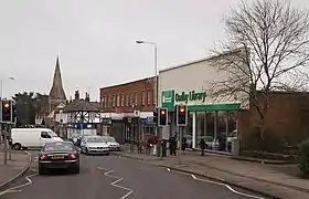 Oadby, one of the two towns that form the borough | |
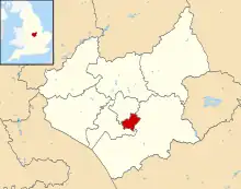 Shown within Leicestershire | |
| Sovereign state | United Kingdom |
| Constituent country | England |
| Region | East Midlands |
| Administrative county | Leicestershire |
| Admin. HQ | Wigston Magna |
| Government | |
| • Type | Oadby and Wigston Borough Council |
| • Leadership: | Alternative - Sec.31 |
| • Executive: | Liberal Democrat |
| • MPs: | Neil O'Brien |
| Area | |
| • Total | 9.08 sq mi (23.53 km2) |
| • Rank | 286th |
| Population (2021) | |
| • Total | 57,753 |
| • Rank | Ranked 291st |
| • Density | 6,400/sq mi (2,500/km2) |
| Time zone | UTC+0 (Greenwich Mean Time) |
| • Summer (DST) | UTC+1 (British Summer Time) |
| ISO 3166-2 | GB-LEC |
| ONS code | 31UJ (ONS) E07000135 (GSS) |
| NUTS 3 | UKF22 |
| Ethnicity | 82.8% White 13.5% S.Asian 1.3% Black British |
| Website | Oadby-Wigston.gov.uk |
Geography
It is composed of the areas of Oadby, Wigston Magna, South Wigston and the hamlet of Kilby Bridge. It is predominantly urban, and borders Leicester directly to the north-west. There are no civil parishes in the district.
The most northerly corner is near the junction of the A6030 and B582, and near the Bupa hospital it meets Harborough. It runs along the B582 then along the former Roman road (which runs to Corby), passing the playing fields of the University of Leicester. It passes along the north edge of Oadby Lodge, a farm owned by the Co-op. Towards the deserted village of Stretton Magna (outside the district), the boundary passes southwestwards. This area was proposed to be the site of the eco-town Pennbury. It crosses the A6 at Glen Gorse Golf Club. It crosses Newton Lane and the Midland Main Line. It crosses the Grand Union Canal, and towards Kilby it meets the district of Blaby at the River Sence. It follows the River Sence, crossing the A5199 (Welford Road). At Rose Farm it follows Countesthorpe Road towards South Wigston, to the Grand Union Canal, crossing the former Midland Counties Railway, which it follows westwards. It passes northwards across St Thomas Road (B582) and the Birmingham to Peterborough Line. It passes northwards on the east side of the Glen Parva prison (in Blaby district). It meets Leicester UA south of Eyres Monsell, a large housing estate.
Following the Leicester boundary, it crosses Saffron Road (B5366), then follows Dorset Avenue, follows the Midland Main Line northwards, crossing Aylestone Lane (B5418), then crosses the Midland Main Line. It crosses the Welford Road (A5199) at the point where the road becomes a dual-carriageway south of the Best Western Leicester Stage Hotel (in Leicester UA). It passes on the south edge of Knighton Park, and the western edge of Oadby Golf Club, west of Leicester Racecourse (in the district). Near the racecourse entrance it crosses the A563 southern ring road, then London Road (A6), passing northwards along the western edge of the University of Leicester's Oadby Student Village, west of the University of Leicester Botanic Garden (in the district).
Demographics
| Population growth in Oadby and Wigston | ||||||||||||
|---|---|---|---|---|---|---|---|---|---|---|---|---|
| Year | 1951 | 1961 | 1971 | 1981 | 1991 | 2001 | 2011 | 2016 | 2021 | 2031 | ||
| Population | 23,943 | 34,206 | 50,253 | 50,014 | 51,542 | 55,773 | 56,170 | 55,800 | 56,500 | 59,700 | ||
| Census [2] | ONS[3] | ONS Projections [4] | ||||||||||
Education
Both Beauchamp College, in the south of Oadby, and Wigston College, on the B582 in Wigston, are former grammar schools. Both were upper schools, as the three tier system operated in the district's schools. Also near the council offices on the B582 is South Leicestershire College, an FE college. Next to the Beauchamp College is Gartree High School, a former middle school. Another school is Manor High School, Oadby, which was the largest middle school in the country.
Oadby and Wigston Borough Council
Oadby and Wigston Borough Council | |
|---|---|
| Type | |
| Type | |
| History | |
| Founded | 1 April 1974 |
| Leadership | |
| Structure | |
| Seats | 26 councillors |
 | |
Political groups |
|
Length of term | 4 years |
| Elections | |
Last election | 4 May 2023 |
| Meeting place | |
 | |
| Council Offices, Station Road, Wigston | |
| Website | |
| https://www.oadby-wigston.gov.uk/ | |
Like many other shire districts, authority over Oadby and Wigston is shared between the borough council and Leicestershire County Council. Areas of responsibility of the borough council include local planning, building control, council housing, refuse collection, recycling, and some leisure services and parks. Oadby and Wigston Borough Council has 26 members. Since 1991 it has been administered by a Liberal Democrat led-executive. Samia Haq has been leader of the council since 5 May 2023.
The composition of the council following the May 2023 election was:
| Party | Seats [5] | |
|---|---|---|
| Liberal Democrats | 19 | |
| Conservative | 7 | |
Historical control
The Conservatives held a majority of seats on the council from its creation in 1973 until 1991. The Liberal Democrats first won a majority in 1991 and have retained control since then.[6][7]
| Party in control | Years | |
|---|---|---|
| Conservative | 1973–1991 | |
| Liberal Democrats | 1991–present | |
Leadership
The leaders of the council since 2014 have been:[8]
| Councillor | Party | From | To | |
|---|---|---|---|---|
| John Boyce | Liberal Democrats | pre-2014 | 5 May 2023 | |
| Samia Haq | Liberal Democrats | 5 May 2023 | ||
Wards

The borough is divided into two and three member wards:
- Oabdy Brocks Hill (2)
- Oadby Grange (3)
- Oadby St Peter's (2)
- Oadby Uplands (2)
- Oadby Woodlands (2)
- South Wigston (3)
- Wigston All Saints (3)
- Wigston Fields (3)
- Wigston Meadowscroft (3)
- Wigston St Walstan's (3)
Arms
|
Freedom of the borough
The following people, military units and Organisations have received the Freedom of the Borough of Oadby and Wigston.
Individuals
- H. Embacher: 1988.
Military units
- The Royal Anglian Regiment: 2011.
- B Squadron Leicestershire and Derbyshire Yeomanry, Royal Yeomanry: 17 April 2012.[10][11]
Organisations and groups
- The University of Leicester: 30 March 2021.[12][13]
Gallery
 Wigston Magna, one of the two towns that form the borough
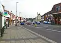
 South Wigston, the largest village in the borough
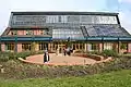 Brocks Hill Borough Council offices at Brocks Hill Country Park
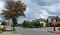 Ash Tree Road in Oadby
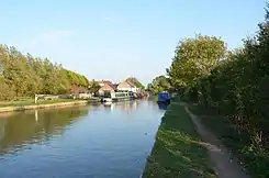 Grand Union Canal - Kilby Bridge
.jpg.webp) South Wigston, Blaby Road
South Wigston, Blaby Road
References
- "Local Government district population 2011". Neighbourhood Statistics. Office for National Statistics. Retrieved 11 June 2016.
- Vision of Britain through time
- mid year estimate
- ONS population projections 2014 base
- "Oadby and Wigston Borough Council".
- "Compositions calculator". The Elections Centre. 4 March 2016. Retrieved 10 August 2022.
- "Oadby & Wigston". BBC News Online. Retrieved 19 March 2010.
- "Council minutes". Oadby and Wigston Borough Council. Retrieved 18 August 2022.
- "East Midlands Region". Civic Heraldry of England. Retrieved 8 March 2021.
- "Freedom of the Borough march to be held in Wigston". Leicester Mercury. 1 May 2012. Archived from the original on 12 September 2012.
- "Freedom of the Borough".
- "University of Leicester granted Honorary Freedom of the Borough". Oadby and Wigston Borough Council. Retrieved 12 July 2021.
- "University of Leicester Granted Freedom of The Borough". In Your Area. 4 April 2021. Retrieved 12 July 2021.
External links
| Unitary authorities | |
|---|---|
| Boroughs or districts | |
| Major settlements (cities in italics) | |
| Topics | |
