List of postcode areas in the United Kingdom
The list of postcode areas in the United Kingdom is a tabulation of the postcode areas used by Royal Mail for the purposes of directing mail within the United Kingdom. The postcode area is the largest geographical unit used and forms the initial characters of the alphanumeric UK postcode.[1] There are currently 121 geographic postcode areas in use in the UK and a further three often combined with these covering the Crown Dependencies of Guernsey, Jersey and Isle of Man.
Subdivision
Each postcode area is further divided into post towns and postcode districts.[1] There are on average 20 postcode districts to a postcode area.[1] The London post town is instead divided into several postcode areas.[2]
Scope
The single or pair of letters chosen for postcode areas are generally intended as a mnemonic for the places served.[1] Postcode areas, post towns and postcode districts do not follow political boundaries and usually serve much larger areas than the place names with which they are associated. For example, within the PA postcode area the PA1 and PA78 postcode districts are 140 miles (225 km) apart; and the eight postcode areas of the London post town cover only 40% of Greater London.[2] The remainder of its area is covered by sections of twelve adjoining postcode areas: EN, IG, RM, DA, BR, TN, CR, SM, KT, TW, HA and UB.[2]
United Kingdom postcode areas
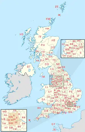
| Postcode area | Postcode area name[1][3] | Code formation | Number of postcode districts within area |
|---|---|---|---|
| AB | Aberdeen | 33 (Highest number 56) | |
| AL | St Albans | 10 | |
| B | Birmingham | 79 (Highest number 98) | |
| BA | Bath | 19 (Highest number 22) | |
| BB | Blackburn | 13 (Highest number 18) | |
| BD | Bradford | 27 (Highest number 99) | |
| BH | Bournemouth | 26 (Highest number 31) | |
| BL | Bolton | 10 (Highest number 9) | |
| BN | Brighton | 30 (Highest number 45) | |
| BR | Bromley | 8 | |
| BS | Bristol | 37 (Highest number 49) | |
| BT | Belfast | 81 (Highest number 94) | |
| CA | Carlisle | 28 | |
| CB | Cambridge | 16 (Highest number 25) | |
| CF | Cardiff | 35 (Highest number 83) | |
| CH | Chester | 37 (Highest number 66) | |
| CM | Chelmsford | 25 (Highest number 77) | |
| CO | Colchester | 16 | |
| CR | Croydon | 8 | |
| CT | Canterbury | 21 | |
| CV | Coventry | 24 (Highest number 47) | |
| CW | Crewe | 12 | |
| DA | Dartford | 18 | |
| DD | Dundee | 11 | |
| DE | Derby | 23 (Highest number 75) | |
| DG | Dumfries[1] | Dumfries and Galloway | 15 (Highest number 16) |
| DH | Durham | 9 | |
| DL | Darlington | 17 | |
| DN | Doncaster | 32 (Highest number 41) | |
| DT | Dorchester | 11 | |
| DY | Dudley | 14 | |
| E | East London | 20 (Includes E1W) | |
| EC | East Central London | 23 (Layout for EC is different, e.g.: EC2R 8AH, highest number 4/4Y) | |
| EH | Edinburgh | 54 (Highest number 55) | |
| EN | Enfield | 11 | |
| EX | Exeter | 33 (Highest number 39) | |
| FK | Falkirk | 21 | |
| FY | Blackpool[1] | The Fylde | 8 |
| G | Glasgow | 52 (Highest number 84) | |
| GL | Gloucester | 27 (Highest number 56) | |
| GU | Guildford | 38 (Highest number 52) | |
| HA | Harrow | 10 (Highest number 9) | |
| HD | Huddersfield | 9 | |
| HG | Harrogate | 5 | |
| HP | Hemel Hempstead | 24 (Highest number 27) | |
| HR | Hereford | 9 | |
| HS | Hebrides | 9 | |
| HU | Hull | 20 | |
| HX | Halifax | 7 | |
| IG | Ilford | Possibly Ilford and Barking | 11 |
| IP | Ipswich | 33 | |
| IV | Inverness | 52 (Highest number 63) | |
| KA | Kilmarnock | Possibly Kilmarnock and Ayr or Kilmarnock | 30 |
| KT | Kingston upon Thames | 24 | |
| KW | Kirkwall | 16 (Highest number 17) | |
| KY | Kirkcaldy | 16 | |
| L | Liverpool | 40 | |
| LA | Lancaster | 23 | |
| LD | Llandrindod Wells[1] | 8 | |
| LE | Leicester | 21 (Highest number 67) | |
| LL | Llandudno | 67 (Highest number 78) | |
| LN | Lincoln | 13 | |
| LS | Leeds | 29 | |
| LU | Luton | 7 | |
| M | Manchester | 43 (Highest number 90) | |
| ME | Medway | 20 | |
| MK | Milton Keynes | 26 (Highest number 46) | |
| ML | Motherwell | 12 | |
| N | North London | 23 (Includes N1C, Highest number 22) | |
| NE | Newcastle upon Tyne[4][5] | 61 (Highest number 71) | |
| NG | Nottingham | 29 (Highest number 34) | |
| NN | Northampton | 19 (Highest number 29) | |
| NP | Newport | 18 (Highest number 44) | |
| NR | Norwich | 35 | |
| NW | North West London | 11 | |
| OL | Oldham | 16 | |
| OX | Oxford | 27 (Highest number 49) | |
| PA | Paisley | 67 (Highest number 80) | |
| PE | Peterborough | 38 | |
| PH | Perth | 43 (Highest number 50) | |
| PL | Plymouth | 35 | |
| PO | Portsmouth | 34 (Highest number 41) | |
| PR | Preston | 11 (Highest number 26) | |
| RG | Reading | 30 (Highest number 45) | |
| RH | Redhill | 20 | |
| RM | Romford | 20 | |
| S | Sheffield | 45 (Highest number 81) | |
| SA | Swansea | 51 (Highest number 73) | |
| SE | South East London | 28 | |
| SG | Stevenage | 19 | |
| SK | Stockport | 19 | |
| SL | Slough | 10 (Highest number 9) | |
| SM | Sutton[1] | Possibly Sutton and Morden, the two post towns that are within the SM area [6] | 7 |
| SN | Swindon | 18 (Highest number 26) | |
| SO | Southampton | 23 (Highest number 53) | |
| SP | Salisbury | Salisbury Plain | 11 |
| SR | Sunderland | 8 | |
| SS | Southend-on-Sea | 17 | |
| ST | Stoke-on-Trent | 21 | |
| SW | South West London | 27 (SW1 is represented by SW1A, -E, -H, -P, -V, -W, -X & -Y, Highest number 20) | |
| SY | Shrewsbury | 25 | |
| TA | Taunton | 24 | |
| TD | Galashiels | Tweeddale | 15 |
| TF | Telford | 13 | |
| TN | Tunbridge Wells[1] | 40 | |
| TQ | Torquay | 14 | |
| TR | Truro | 27 | |
| TS | Teesside | 29 | |
| TW | Twickenham | 20 | |
| UB | Southall[1] | Uxbridge | 11 |
| W | West London | 26 (W1 is split into W1A through W1D, -F to -H, -J, -K, -S through -U and -W, highest number 14) | |
| WA | Warrington | 16 | |
| WC | West Central London | 14 (WC1 is split into eight, WC2 is split into six, highest number 2/2R) | |
| WD | Watford | 11 (Highest number 25) | |
| WF | Wakefield | 17 | |
| WN | Wigan | 8 | |
| WR | Worcester | 15 | |
| WS | Walsall | 15 | |
| WV | Wolverhampton | 16 | |
| YO | York | 29 (Highest number 47) | |
| ZE | Lerwick[1] | Zetland | 3 |
Crown dependencies
The Crown dependencies (which are not part of the United Kingdom) did not introduce postcodes until later, but use a similar coding scheme. They are separate postal authorities.[1]
| Postcode area | Postcode area name |
|---|---|
| GY | Guernsey |
| JE | Jersey |
| IM | Isle of Man |
Defunct postcode areas
London NE and S
Glasgow
Glasgow, like London, was divided into compass districts: C, W, NW, N, E, SE, S, SW. When postcodes were introduced, these were mapped into the new G postcode: C1 became G1, W1 became G11, N1 became G21, E1 became G31, S1 became G41, SW1 became G51, and so on. As NW and SE had never been subdivided they became G20 and G40 respectively.
Norwich and Croydon
Norwich and Croydon were used for a postcode experiment in the late 1960s, which was replaced by the current system. The format was of the form NOR or CRO followed by two numbers and a letter, e.g. NOR 07A. They were later changed to CR0 (digit '0') and NR1.
Dublin, Ireland
When Ireland was a part of the United Kingdom of Great Britain and Ireland a postal district system was introduced in 1917 by the UK government. The letter D was assigned to Dublin. Upon the establishment of the Irish Free State and later, the Republic of Ireland, the Irish government retained the designation and today it forms part of the Eircode system, a postcode format slightly different from the UK format and identifying individual addresses. Since Irish independence, D has never been reassigned as a postcode area in the UK.
Non-geographic postcodes
Some postcode areas do not correspond to geographical areas. A number of non-geographic postcode sectors are also contained within geographic postcode areas.
BF
The BF postcode area was introduced in 2012 to provide optional postcodes for British Forces Post Office addresses, for consistency with the layout of other UK addresses. It uses the national non-geographic post town "BFPO" and, as of 2012, the postcode district "BF1".
BX
The non-geographic postcode area BX has been introduced for addresses which do not include a locality: this allows large organisations long-term flexibility as to where they receive their mail. This postcode area is used by Lloyds Banking Group (BX1 1LT), HSBC (BX8 0HB) and parts of the HM Revenue and Customs like VAT Central Unit (BX5 5AT) and Pay as You Earn (BX9 1AS). Lloyds Bank also use BX4. After splitting from Lloyds, TSB Bank uses BX4 7SB, the latter part of which, when written, looks similar to "TSB".
GIR
GIR 0AA is a postcode created for Girobank in Bootle. It remained in use by its successors when Girobank was taken over by Alliance & Leicester and subsequently by Santander UK.
XM
XM4 5HQ is a postcode created for Father Christmas.
XX
The non-geographic postcode area XX is used by online retailers for returns by Royal Mail, and for COVID-19 test samples.
| Retailer (or other user) | XX Postcodes |
|---|---|
| Adidas | XX40 4AA |
| Amazon | XX10 1DD (Scottish Distribution Centre)[7] XX10 1ZZ (Yorkshire Distribution Centre) XX30 1FF (South West Distribution Centre) XX40 2PP (National Distribution Centre) XX50 1DD (Scottish Distribution Centre) XX50 9SS (Scottish Distribution Centre) XX60 1XX (Princess Royal Distribution Centre) |
| ASOS | XX10 1AA |
| Boohoo.com | XX10 1BB |
| BT Group | XX10 1BT |
| John Lewis | XX10 1EE XX40 1EE |
| Marks & Spencer | XX10 1SS |
| Very | XX20 1BD |
| musicMagpie | XX10 1FF XX20 1BF XX20 1FF |
| HP / Cycleon Retail Returns | XX40 1EH XX40 2HH (toner cartridge recycling) |
| Zara | XX40 1EJ |
| Mango | XX40 1EN |
| Monsoon Accessorize | XX40 1EP |
| Boden | XX40 1EG |
| H&M | XX40 1HN |
| Oasis | XX40 1YY |
| Shein | XX40 3SS |
| Temu | XX40 1ZZ |
| Sky | XX40 4UU |
| Biocentre (COVID-19 testing) | XX40 4FL |
| AstraZeneca (COVID-19 testing) | XX40 8AZ |
| Biocentre (COVID-19 testing) Scotland | XX50 5FL |
Overseas territories
Certain British Overseas Territories introduced single postal codes for their territory or major sub-sections of it. These are not UK postcodes, even though many are formatted in a similar fashion:
| Territory | Postcode |
|---|---|
| AI-2640[8] | |
| Saint Helena, Ascension and Tristan da Cunha: | ASCN 1ZZ STHL 1ZZ TDCU 1ZZ |
| BBND 1ZZ | |
| BIQQ 1ZZ | |
| FIQQ 1ZZ[10] | |
| GX11 1AA | |
| PCRN 1ZZ | |
| SIQQ 1ZZ | |
| TKCA 1ZZ[11] | |
Other overseas territories have introduced their own more extensive postcode systems:
Civilian residential and business addresses in Akrotiri and Dhekelia are served by Cyprus Postal Services and use Cypriot postal codes.
Mail to Overseas Territories is treated as international if posted in the UK.
See also
Notes
References
- Address Management Guide (5th ed.). Royal Mail Group plc. March 2007. Archived from the original on 8 November 2012. Retrieved 22 October 2012.
- HMSO, The Inner London Letter Post, (1980)
- Office for National Statistics (1999). The Official Yearbook of the United Kingdom (PDF) (2000 ed.). London: The Stationery Office. "UK Postal Areas", map opposite p. 5. ISBN 0-11-621098-2. Archived (PDF) from the original on 30 October 2012. Retrieved 22 October 2012.
- Manger, Warren (26 August 2014). "40 facts about the postcode to mark 40th anniversary as vital part of daily life". mirror.co.uk. mirror.co.uk. Archived from the original on 16 March 2018. Retrieved 16 March 2018.
- "History of the UK Postcode - Modern Origin". postcodearea.co.uk. postcodearea.co.uk. Archived from the original on 18 October 2017. Retrieved 16 March 2018.
- "Postcodes in the UK - Jonathan Rawle's Website". jonathan.rawle.org. Archived from the original on 29 April 2018. Retrieved 29 April 2018.
- Amazon Help [@AmazonHelp] (24 October 2016). "@MarkWickson This postcode is a non-geographic code used by us for returns carried by Royal Mail to our returns center Dunfermline, SCT. ^SW" (Tweet) – via Twitter.
- "Anguilla Has a Postal Code, AI-2640". The Anguillian. 12 October 2007. Archived from the original on 14 May 2010.
- "First postcode for remote UK isle". BBC News. 7 August 2005. Archived from the original on 24 December 2008.
- "Rammell welcomes new Postcode for the Falkland Islands". Merco Press. 19 May 2003.
- Turks and Caicos Islands Archived 10 April 2008 at the Wayback Machine. Bureau International UPU.
External links
- Office for National Statistics - Postal geography
- OpenStreetMap - Postcode map
- Strowger net: postcodes of the UK Archived 24 July 2010 at the Wayback Machine
- UK Business Lists - Map of UK Postcodes
- Direct Marketing Lists UK postcode map
- Business Lists UK postcode map
- FREE Vector UK Postcode Maps
- PostcodeArea - Demographics, maps, crime rates, house prices and local information for all UK postcodes
- Strange Maps - Frank Jacobs - Diagrammatic Map
- All UK Postcodes Filter By Postcode Area