Sar Aqa Seyyed
Sar Agha Seyed (Persian: سراقاسيد, also Romanized as Sar Āqā Seyyed)[3] is a village in Miankuh-e Moguyi Rural District of the Central District of Kuhrang County, Chaharmahal and Bakhtiari province, Iran.
Sar Aqa Seyyed
Persian: سراقاسيد | |
|---|---|
Village | |
 Sar Aqa Seyyed | |
 Sar Aqa Seyyed | |
| Coordinates: 32°39′33″N 49°51′53″E[1] | |
| Country | |
| Province | Chaharmahal and Bakhtiari |
| County | Kuhrang |
| District | Central |
| Rural District | Miankuh-e Moguyi |
| Population (2016)[2] | |
| • Total | 1,698 |
| Time zone | UTC+3:30 (IRST) |
At the 2006 census, its population was 1,360 in 208 households.[4] The following census in 2011 counted 1,236 people in 275 households.[5] The latest census in 2016 showed a population of 1,698 people in 380 households; it was the largest village in its rural district.[2] The village is populated by Lurs.[6]
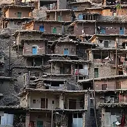
The village is named after Aqa Seyyed shrine. It is known for its unusual architecture. Its interconnected buildings are built into the surrounding mountain. The roofs of the buildings serve as courtyards and streets of the buildings above. Most of the homes have no windows and only one door.[7][8]
Because of the similarity of architecture, Sar Aqa Seyyed village is called The Masuleh of Zagros. Also, tourists explore this village for its nomads too.[9]
External links
 Media related to Sar Aqa Seyyed at Wikimedia Commons
- "Sar Aqa Seyyed: Village with Spectacular Architecture". Iran Student Correspondence Association. 15 September 2017.
References
- OpenStreetMap contributors (2 April 2023). "Sar Aqa Seyyed, Kuhrang County" (Map). OpenStreetMap. Retrieved 2 April 2023.
- "Census of the Islamic Republic of Iran, 1395 (2016)". AMAR (in Persian). The Statistical Center of Iran. p. 14. Archived from the original (Excel) on 24 May 2019. Retrieved 19 December 2022.
- Sar Aqa Seyyed can be found at GEOnet Names Server, at this link, by opening the Advanced Search box, entering "-3082511" in the "Unique Feature Id" form, and clicking on "Search Database".
- "Census of the Islamic Republic of Iran, 1385 (2006)". AMAR (in Persian). The Statistical Center of Iran. p. 14. Archived from the original (Excel) on 20 September 2011. Retrieved 25 September 2022.
- "Census of the Islamic Republic of Iran, 1390 (2011)" (Excel). Iran Data Portal (in Persian). The Statistical Center of Iran. p. 14. Retrieved 19 December 2022.
- "Language distribution: Chahar Mahal va Bakhtiari Province". Iran Atlas. Retrieved 25 March 2021.
- "A mountain village built on rooftops". Tehran Times. 25 December 2017.
- "Iran's Farsian: A Village on Rooftops". Tasnim News Agency. 29 October 2017.
- "Sar Agha Seyed Village features special construction". ISNA. 21 August 2019. Retrieved 20 March 2020.
| Capital |  | ||||||||||||||||||||||
|---|---|---|---|---|---|---|---|---|---|---|---|---|---|---|---|---|---|---|---|---|---|---|---|
| Counties and cities |
| ||||||||||||||||||||||
| Landmarks |
| ||||||||||||||||||||||
| populated places | |||||||||||||||||||||||