Sar Mashhad
Sar Mashhad (Persian: سرمشهد; also known as Sar Meshad)[3] is a village in Dadin Rural District of Jereh and Baladeh District, Kazerun County, Fars province, Iran. The inhabitants of Sar Mashhad are from the Qashqai tribe, Farsimdan tribe and speak Qashqai Turkish.[4]
Sar Mashhad
Persian: سرمشهد | |
|---|---|
Village | |
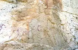
 Rock relief of Bahram II at Sar Mashhad | |
 Sar Mashhad | |
| Coordinates: 29°17′25″N 51°42′14″E[1] | |
| Country | |
| Province | Fars |
| County | Kazerun |
| District | Jereh and Baladeh |
| Rural District | Dadin |
| Population (2016)[2] | |
| • Total | 2,818 |
| Time zone | UTC+3:30 (IRST) |
At the 2006 National Census, its population was 3,047 in 623 households.[5] The following census in 2011 counted 2,878 people in 684 households.[6] The latest census in 2016 showed a population of 2,818 people in 748 households. It was the largest village in its rural district.[2]
The place is notable for being the site of a Sasanian rock relief made during the reign of king (shah) Bahram II (r. 274–293).[7] The relief portrays him as a hunter who has slain a lion while throwing his sword at another.[7] His wife is holding his right hand in a signal of safeguard, while the high priest Kartir and another figure, most likely a prince, are watching.[7] The scenery has been the subject of several symbolic and metaphorical meanings, though it is most likely supposed to portray a simple royal display of bravery during a real-life hunt.[7] An inscription of Kartir is underneath the relief.[7]
Distance from important cities
- Kazerun 65 km
- Shiraz 169 km
- Ishahan 540 km
- Tehran 970 km
See also
References
- OpenStreetMap contributors (22 September 2023). "Sar Mashhad, Kazerun County" (Map). OpenStreetMap. Retrieved 22 September 2023.
- "Census of the Islamic Republic of Iran, 1395 (2016)". AMAR (in Persian). The Statistical Center of Iran. p. 07. Archived from the original (Excel) on 6 April 2022. Retrieved 19 December 2022.
- Sar Mashhad can be found at GEOnet Names Server, at this link, by opening the Advanced Search box, entering "-3082934" in the "Unique Feature Id" form, and clicking on "Search Database".
- The Cambridge History of Iran, Volume 3
- "Census of the Islamic Republic of Iran, 1385 (2006)". AMAR (in Persian). The Statistical Center of Iran. p. 07. Archived from the original (Excel) on 20 September 2011. Retrieved 25 September 2022.
- "Census of the Islamic Republic of Iran, 1390 (2011)" (Excel). Iran Data Portal (in Persian). The Statistical Center of Iran. p. 07. Retrieved 19 December 2022.
- Shahbazi 1988, pp. 514–522.
Sources
- Shahbazi, A. Shapur (1988). "Bahrām II". Encyclopaedia Iranica, Vol. III, Fasc. 5. pp. 514–522.
Further reading
- Canepa, Matthew (2018). "Sar Mashhad". In Nicholson, Oliver (ed.). The Oxford Dictionary of Late Antiquity. Oxford: Oxford University Press. ISBN 978-0-19-866277-8.
