Rudnichnoye
Rudnichnoye (Kazakh: Рудничное), also known as Shalkarkol (Kazakh: Шалқаркөл), is a lake in Bukhar-Zhyrau District, Karaganda Region, and Bayanaul District, Pavlodar Region, Kazakhstan.[1][2]
| Rudnichnoye | |
|---|---|
| Рудничное | |
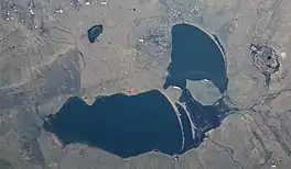 ISS image of the lake | |
 Rudnichnoye | |
| Location | Kazakh Uplands |
| Coordinates | 49°53′N 74°48′E |
| Type | endorheic |
| Basin countries | Kazakhstan |
| Max. length | 4.2 kilometers (2.6 mi) |
| Max. width | 2.4 kilometers (1.5 mi) |
| Surface area | 6.5 square kilometers (2.5 sq mi) |
| Average depth | 4.5 meters (15 ft) |
| Max. depth | 8.5 meters (28 ft) |
| Residence time | UTC+6 |
Rudnichnoye is located about 3 kilometers (1.9 mi) northeast of Semizbughy village. Shalkar village (formerly "Pobeda"), lies close to the lakeshore at the northern end.[3][4] The lake and its surroundings are a destination for tourists.[5]
Geography
Rudnichnoye is an endorheic lake lying in the Kazakh Uplands, about 20 kilometers (12 mi) to the north of the northern slopes of the Ayr Mountains. It consists of a larger western lake and a smaller eastern one, separated by a double landspit and a peninsula, and connected by a sound. The water is brackish and hard. The highest level of the lake is in April, following the melting of the snow, and the lowest after the summer, in September.[4]
The border between Karaganda Region and Pavlodar Region cuts across Rudnichnoye's northwestern tip. Smaller lake Kandykol lies 10 kilometers (6.2 mi) to the WNW. 1,049 meters (3,442 ft) high mount Semizbughy rises to the south, above the southern shore of the lake.[3][1]
Flora and fauna
The lake has few aquatic plants; the main fish species in its waters are perch, pike, karabalik and carp.[4]
See also
References
- "M-43 Topographic Chart (in Russian)". Retrieved 18 August 2022.
- Google Maps
- Google Earth
- ATAMEKEN: Geographical encyclopedia. / General ed. B. O. Jacob. - Almaty: "Kazakh Encyclopedia", 2011. - 648 pages. ISBN 9965-893-70-5
- VeloKaraganda / Semizbuga 2009
External links
 Media related to Rudnichnoye at Wikimedia Commons
- Караганда 2020: Семизбуга - курорт Рудничное
- "Тайна четырёх озёр" - Autotourist.kz (in Russian)
- Kazakhstan Today — В озере Рудничное в Карагандинской области обнаружено тело пропавшего мужчины