Sulu
Sulu ([sʊˈlu]), officially the Province of Sulu (Tausūg: Wilāya sin Lupa' Sūg; Tagalog: Lalawigan ng Sulu), is a province of the Philippines in the Sulu Archipelago and part of the Bangsamoro Autonomous Region in Muslim Mindanao (BARMM).
Sulu
| |
|---|---|
| Province of Sulu | |
 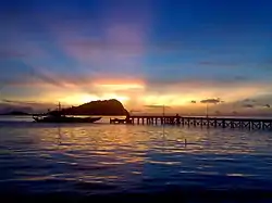   (from top: left to right) Sulu Provincial Capitol Building in Jolo, scenery in Hadji Panglima Tahil, sunrise in Lugus and Tulay Mosque in Jolo. | |
 Flag  Seal | |
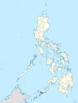 Location in the Philippines | |
OpenStreetMap | |
| Coordinates: 6°N 121°E | |
| Country | |
| Region | |
| Founded | March 10, 1917 |
| Capital | |
| Largest Municipality | Jolo |
| Government | |
| • Type | Sangguniang Panlalawigan |
| • Governor | Abdusakur M. Tan (PDP-Laban) |
| • Vice Governor | Abdusakur A. Tan II (PDP-Laban) |
| • Legislature | Sulu Provincial Board |
| Area | |
| • Total | 1,600.40 km2 (617.92 sq mi) |
| • Rank | 66th out of 81 |
| Highest elevation (Mount Tumatangis) | 811 m (2,661 ft) |
| Population (2020 census)[3] | |
| • Total | 1,000,108 |
| • Rank | 28th out of 81 |
| • Density | 620/km2 (1,600/sq mi) |
| • Rank | 10th out of 81 |
| Demonym(s) | Suluan Tausug |
| Divisions | |
| • Independent cities | 0 |
| • Component cities | 0 |
| • Municipalities | |
| • Barangays | 410 |
| • Districts | Legislative districts of Sulu |
| Time zone | UTC+8 (PHT) |
| ZIP code | 7400–7416 |
| IDD : area code | +63 (0)68 |
| ISO 3166 code | PH-SLU |
| Spoken languages | |
| Income classification | 2nd class |
Its capital is Jolo on the island of the same name.[4] Maimbung, the royal capital of the Sultanate of Sulu, is also located in the province. Sulu is along the southern border of the Sulu Sea and the northern boundary of the Celebes Sea.
Out of all 82 provinces in the Philippines, it is the poorest, as evidenced by it having the highest poverty rate.
History
Early history
Prior to the arrival of Islam in Sulu, the province used to adhere to local animist religions; this later changed to Hindu and Buddhist belief systems. Throughout this time, the Kingdom of Lupah Sug had been established centuries before Islam arrived.
The advent of Islam around 1138 through merchants and traders had a distinct influence on Southeast Asia. The coming of Arabs, Persians and other Muslims paved the way for the arrival of religious missionaries, traders, scholars and travelers to Sulu and Mindanao in the 12th century.
A landmark born of the social process was the founding of the Sultanate of Sulu. Year 1380 CE, The Sunni Sufi Scholar Karim-ul Makhdum came to Sulu and introduced Islam to the Philippines. In 1450 CE, Johore-born Arab adventurer Sayyid Abubakar Abirin came to Sulu and lived with Rajah Baguinda Ali. The Sunni Sufi Teacher and Sayyid Abubakar eventually married Ali's daughter, Dayang-dayang Paramisuli, and inherited Rajah Baguinda's polity (which was a principality before), which he turned into the Sultanate of Sulu and become its first Sultan. To consolidate his rule, Sayyid Abubakar united the local political units under the umbrella of the Sultanate. A Sultanate that followed the Ash'ari Aqeeda, Shafi'i Madh'hab and Sufism. He brought Sulu, Zamboanga Peninsula, Palawan, and Basilan under its aegis.
Spanish colonial era
The navigational error that landed Ferdinand Magellan in Limasawa brought awareness of Europe to the Philippines and opened the door to Spanish colonial incursion. The Spaniards introduced Christianity and a political system of church-state dichotomy, which encountered fierce resistance in the devastating Moro wars from 1578 to 1899. The Sultanate of Sulu formally recognised Spanish sovereignty in Tawi-Tawi and Sulu in middle of 19th century, but these areas remained partially ruled by the Spanish as their sovereignty was limited to military stations, garrisons, and pockets of civilian settlements, until they had to abandon the region as a consequence of their defeat in the Spanish–American War.
American era
After Spain ceded the Philippines to the United States, American forces came to Jolo and ended the 23 years of Spanish military occupation (1876 to 1899). On August 20, Sultan Jamalul Kiram II and Brig. Gen. John C. Bates signed the Bates Agreement that continued the gradual emasculation of the Sultanate started by Spain (Treaty of 1878) until March 1915 when the Sultan abdicated his temporal powers in the Carpenter Agreement. The Agreement eliminated opposition to the civilian government of Gov. Clinton Solidum.
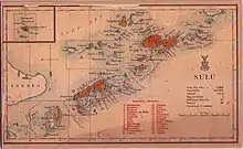
The Department of Mindanao and Sulu under Gov. Carpenter was created by Philippine Commission Act 2309 (1914) and ended on February 5, 1920, by Act of Philippine Legislature No. 2878. The Bureau of Non-Christian Tribes was organized and briefly headed by Teofisto Guingona Sr. With the enactment by the US Congress of the Jones Law (Philippine Autonomy Law) in 1916, ultimate Philippine independence was guaranteed and the Filipinization of public administration began. Sulu, however, had an appointed American governor until 1935, and the Governor General in Manila had a say in Sulu affairs.
At any rate, the essence of local governance forged by Rajah Baguinda continued to permeate the ethos of Sulu politics despite centuries of colonial presence. History points to a local government in Sulu that antedates other similar systems in the country.
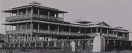
The province hosted the Daru Jambangan (Palace of Flowers) which was the royal palace of the Sultan of Sulu since historical times. The palace, located in Maimbung was made of wood, and was destroyed in 1932 by a huge storm.
Japanese occupation
During the brief Japanese occupation years, Sulu was bombed by the Japanese and was conquered afterwards. The Japanese were eventually expelled by the Americans and the natives of Sulu, and the Americans started to push for the independence of the Philippines as 'one country'. This prompted various leaders from Mindanao and the Sulu archipelago to campaign against being lumped with the Catholic natives of Luzon and the Visayas. Despite the campaign against the 'one Philippines model', the United States granted independence to the Philippines, effectively giving control of Mindanao and the Sulu archipelago to the Filipino government in Manila.
Philippine independence
At the beginning of Philippine independence era, the reconstruction of the Daru Jambangan continued to be of huge importance to the people of Sulu as only a few arches and posts remain from the once grand palace complex. Many members of the royal family advocated for the reconstruction of the palace, however, the government of the Philippines made no official position or fund for the matter. During that time, the Mindanao sentiment to become a free country on its own was also felt in Sulu.
In 1948, Hadji Kamlon, a World War II veteran, started an uprising on Luuk, Sulu. He surrendered in 1949 but started another uprising in 1952. He then surrendered on July 31, 1952, to Secretary of Defense Ramon Magsaysay. However, he started a third uprising a week later. He surrendered again on November 9, 1952, but would start another uprising in early 1953. He would then surrender on August 11, 1953, after an encounter with Philippines Government troops. He violated the terms of his surrender a week later. Two years later, on September 24, 1955, he would then surrender after an encounter with government troops in Tandu Panuan, Luuk.
In 1973, the municipalities of South Ubian, Tandubas, Simunul, Sitangkai, Balimbing (Panglima Sugala), Bungao, Cagayan de Sulu (Mapun), and Turtle Island were transferred from the jurisdiction of Sulu to the newly formed province of Tawi-Tawi pursuant to Presidential Decree No. 302 of September 11, 1973.[5]
The Marcos Administration
During Marcos era, Sulu was one of the provinces that fought back against Ferdinand Marcos as his regime tortured, killed, and exterminated hundreds of Moros. When news broke out regarding the planned invasion of eastern Sabah, Marcos ordered the military to massacre Tausug warriors, which led to the brutal 1968 Jabidah massacre, the worst human rights violation against the natives of Sulu.
News about the Jabidah Massacre led to the rise of numerous separatist movements in Mindanao, including Sulu, eventually leading to groups engaging in armed conflict with the Philippine government.[6][7] One of the most destructive clashes, the 1974 Battle of Jolo,[8] was so destructive that it was estimated to have rendered 40,000 people homeless in Jolo, the capital of Sulu.[9]
The Sultan of Sulu, members of the royal family, and the leaders of Sulu were in favor of the People Power Revolution in Manila that successfully toppled the dictatorship and restored democracy in the country.
Contemporary
In 1989, the province of Sulu became part of the Autonomous Region in Muslim Mindanao or ARMM. A peace pact between the Moro National Liberation Front or MNLF and the Philippine government was also made. The founder and leader of the MNLF, Nur Misuari, who was a native of Sulu and adhered to the Sultanate of Sulu, became the governor of the entire ARMM from 1996 to 2001.
In 2016, a small replica of Daru Jambangan was built in the neighboring town of Talipao and became a centerpiece for a 'vacation park'. The replica was about 25% of the actual size of the real Daru Jambangan during its heyday. A campaign to restore the Daru Jambangan in its original location in Maimbung is still ongoing. The National Commission for Culture and the Arts and the National Museum of the Philippines were tasked to faithfully restore or reconstruct the Daru Jambangan in Maimbung.[10]
In 2019, the Bangsamoro autonomy plebiscite led to the ratification of the Bangsamoro Organic Law (BOL) creating the Bangsamoro Autonomous Region in Muslim Mindanao (BARMM) to replace the ARMM. The initiative lost by a 54.3% margin in Sulu, but was carried nonetheless because the votes of the entire ARMM were counted as one. (Several other localities in Mindanao which had not originally been part of the ARMM also ratified the BOL and were thus added to the BARMM.)[11]
Geography

The province covers an area of 1,600.40 square kilometres (617.92 sq mi).[2] Sulu's main island, Jolo, has an area of 868.5 square kilometres (335.3 sq mi),[12] making it the 16th largest island of the Philippine Archipelago by area.
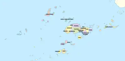
Sulu is a part of the Sulu Archipelago, which stretches from the tip of the Zamboanga Peninsula on the north to the island of Borneo in the south. The main island and its islets are situated between the island-provinces of Basilan to the northeast, and Tawi-Tawi to the southwest. Sulu is bordered by two seas; the Sulu Sea to the north, and the Celebes Sea to its south. Sulu has over 157 islets, some of which remain unnamed.[1]
The islands are organized into four groups:[1]
- Jolo group
- Pangutaran group
- Tongkil-Banguingui (Samales) group
- Siasi-Tapul group
Administrative divisions
Sulu comprises 19 municipalities that are organized into two legislative districts and further subdivided into 410 barangays.
|
† Provincial capital
| ||||||||||||||||||||||||||||||||||||||||||||||||||||||||||||||||||||||||||||||||||||||||||||||||||||||||||||||||||||||||||||||||||||||||||||||||||||||||||||||||||||||||||||||||||||||||||||||||||||||||||||||||||||||||||||||||||||||||||||||||||||||||||||||||||||||||||||||||||||||||||||||||||||
Demographics
| Year | Pop. | ±% p.a. |
|---|---|---|
| 1903 | 73,914 | — |
| 1918 | 127,977 | +3.73% |
| 1939 | 201,348 | +2.18% |
| 1948 | 182,295 | −1.10% |
| 1960 | 248,304 | +2.61% |
| 1970 | 315,421 | +2.42% |
| 1975 | 240,001 | −5.33% |
| 1980 | 360,588 | +8.48% |
| 1990 | 469,971 | +2.69% |
| 1995 | 536,201 | +2.50% |
| 2000 | 619,668 | +3.15% |
| 2007 | 849,670 | +4.45% |
| 2010 | 718,290 | −5.93% |
| 2015 | 824,731 | +2.67% |
| 2020 | 1,000,108 | +3.86% |
| Source: Philippine Statistics Authority[14][16][17] | ||
The population of Sulu in the 2020 census was 1,000,108 people,[3] with a density of 620 inhabitants per square kilometre or 1,600 inhabitants per square mile.
Although consisting of a mixed community of Muslims, the Tausugs dominate the Sulu Archipelago. The Tausug were among the first inhabitants of the Philippines to embrace Islam as a religion and a way of life. They are referred to as ‘people of the current’, reflective of their close ties to the sea.
Religion

Sulu inhabitants are predominantly Muslim, constituting about 99%[18] of the provincial population in 2015.
A majority of Sulu's Muslim population practice Sunni Islam of the Shafi'i tradition, as taught by Arab, Persian, Indian Muslim, Chinese Muslim and Malaccan missionaries from the 14th Century onwards.
Relatively newer Islamic sects, mostly brought by returning veterans of the Afghan wars and missionaries from Pakistan's stricter Sufi traditions, referred to as the Tableegh, have been active in propagating what they believe to be a "purer" Islamic way of life and worship. A very small number who have since married into Iranian or Iraqi families have converted to Shiite Islam.
The majority of Sulu Christians are Catholics.[1] They are under the jurisdiction of Archdiocese of Zamboanga through its suffragan Apostolic Vicariate of Jolo. Non-Catholic Christians include Evangelicals, Jesus Miracle Crusade, Episcopalian, Iglesia ni Cristo (INC), Mormons, Seventh-day Adventists, Jehovah's Witnesses, and a number of other Protestant denominations. Only the most recent Chinese immigrants adhere to Buddhism or Taoism, while most of the older Chinese families have acculturated and have either converted to Christianity or Islam while retaining many of their Chinese beliefs.
Languages
The Tausug language is the lingua franca of Sulu. The other local language is the indigenous Sama, which is widely used in varied tones and accents. This variety led to the development of Sinama dialects. The major ones are Sinama Sibutu (spoken mainly in the Sibutu-Sitangkai Region), Sinama Simunul (concentrated in Simunul-Manuk-Mangkaw Islands), Sinama Kapoan (spoken in the South Ubian-Tandubas and Sapa-Sapa Regions) and Sinama Banguingui (concentrated in Buan Island and spoken by Banguingui people).
The Bajau-Sama language is also spoken, as are the official languages of Tagalog (Filipino) and English. Many locals and barter traders can speak Sabah Malay, while Chavacano is also spoken by Christian and Muslim locals who maintain contacts and trade with the mainland Zamboanga Peninsula and Basilan. Many Muslims can also speak Cebuano because of the mass influx of Cebuano settlers to Mindanao, especially among the Tau Sūg since Tausug is a related Visayan language.
- Tausug
- Pangutaran Sama
- Balangingih Sama
- Yakan
- Southern Sama
- Central Sama
- Mapun
- Ibatag
- Central Subanen
- Western Subanon
- Kolibugan Subanen
Government
Governors after People Power Revolution 1986:
- 1986 - 1989: Habib Loong
- 1989 - 1992: Habib Loong
- 1992 - 1995: Habib Loong
- 1996 : Sayyid Al Hassan Caluang, OIC Governor
- 1996 - 1998: Abdusakur Mahail Tan
- 1998 - 2001: Abdusakur Tan
- 2001 - 2004: Yusop Jikiri
- 2004 - 2007: Benjamin Loong
- 2007 - 2010: Abdusakur Tan
- 2010 - 2013: Abdusakur Tan
- 2013 - 2016: Abdusakur Tan II
- 2016 - 2019: Abdusakur Tan II
- 2019 - present: Abdusakur Tan
Vice Governors after People Power Revolution 1986:
- 1986 - 1989,
- 1989 - 1992: Kimar Tulawie
- 1992 - 1995:
- 1995 - 1998,
- 1998 - 2001: Munib Estino
- 2001 - 2004: Abdel Anni
- 2004 - 2007: Nur-Ana Sahidulla
- 2007 - 2010: Nur-Ana Sahidulla
- 2010 - 2013: Benjamin Loong
- 2013 - 2016: Abdusakur Tan
- 2016 - 2019: Nurunisah Tan
- 2019 - present: Abdusakur Tan II
Economy
Sulu is predominantly agricultural with farming and fishing as its main livelihood activities. Its fertile soil and ideal climate can grow a variety of crops such as abaca, coconuts, Sulu coffee,[26] oranges, and lanzones as well as exotic fruits seldom found elsewhere in the country such as durian and mangosteen.
Fishing is the most important industry since the Sulu Sea is one of the richest fishing grounds in the country. The province also has an extensive pearl industry, with a pearl farm on Marungas Island. The backs of sea turtles are made into beautiful trays and combs. During breaks from fishing, the people build boats and weave mats. Other industries include coffee processing and fruit preservation.
The handicrafts of Sulu have both Islamic and Malay influences. Skilled artisans make boats, bladed weapons, bronze and brassware, pis cloth, embroidered textiles, shellcraft, traditional house carvings, and carved wooden grave markers.
The province used to be one of the most prosperous in the southern Philippines. However, due to conflicts, terrorism, and the establishment of jihadists groups following Wahhabism such as the Abu Sayyaf, the province's economy has suffered badly and has been reduced to its current state.
Transportation
After the success of new flight of Philippine Airlines inside Bangsamoro region, the government is already looking forward to open the route to Cotabato City. As of to date Gove Leading Edge,[27] Cebu Pacific Cebgo and Platinum Skies from Zamboanga are existing operational flight utilizing the newly renovated Jolo Airport.
Notable people
- Hadji Butu – Filipino statesman, first Muslim member of the Senate of the Philippines.
- Santanina Tillah Rasul – Filipina politician and the first Muslim woman member of the Senate of the Philippines.
- Antonio Kho Jr. – 193rd Associate Justice of the Supreme Court of the Philippines
- Abdulmari Imao – National Artist of the Philippines for Visual Arts – Sculptur
- Leonor Orosa-Goquingco – National Artist of the Philippines for Dance
- Samuel K. Tan – historian and former chairperson of National Historical Commission of the Philippines
- Kerima Polotan Tuvera – fiction writer, essayist, and journalist
- Mohammed Esmail Kiram I – Sultan of Sulu from 1950 to 1974
- Princess Tarhata Kiram – Moro leader
- Mohammed Mahakuttah Abdullah Kiram – last Sultan of Sulu officially recognized by Philippine government
- Jamalul Kiram III – self-proclaimed Sultan of Sulu
- Nur Misuari - leader of the Moro National Liberation Front
- Muedzul Lail Tan Kiram – crown prince of Sultan Mahakuttah Kiram and current head of the Royal house of Sulu. Sunni, Ash'ari in Aqeeda and Shafi'i in Madh'hab, leader.
- Tuburan Tamse – swimmer and the first Muslim Filipino Olympian
See also
References
- "Brief Profile". Province of Sulu, Philippines. Archived from the original on February 26, 2011. Retrieved April 18, 2016.
Various government agencies report varying land areas for Sulu. According to the National Mapping and Resources Information Authority, Sulu has a total land area of 160,040 hectares. On the other hand, based on the Philippine Statistics Authority (NSO) 2000 Demographic and Socio-Economic profile, the province has a land area of 1,754.6.
- Province of Sulu: Brief Profile Archived February 26, 2011, at the Wayback Machine (There seems to be major discrepancies among authoritative sources: 343,699 ha (NSCB 2007), 175,460 ha (NSCB 2000), 167,377 ha (NAMRIA))
- Census of Population (2020). Table B - Population and Annual Growth Rates by Province, City, and Municipality - By Region. Philippine Statistics Authority. Retrieved July 8, 2021.
- "Jolo Branch Museum". National Museum. Archived from the original on August 2, 2019. Retrieved February 22, 2020.
- "Presidential Decree No. 302, s. 1973 | GOVPH". Official Gazette of the Republic of the Philippines. Retrieved September 14, 2021.
- Majul, Cesar A. (1985). The Contemporary Muslim Movement in the Philippines. Mizan Press. p. 45.
- Yegar, Moshe (2002). Between Integration and Secession: The Muslim Communities of the Southern Philippines, Southern Thailand and Western Burma/Myanmar. Lexington Books. pp. 267–268.
- "ARMM gov: Martial Law killings a 'painful part of our history as Moros'". The Philippine Star. September 24, 2018. Archived from the original on September 24, 2018. Retrieved October 6, 2019.
- Cal, Ben (September 11, 2013). "MNLF's first try to raise flag was 39 years ago". Manila Bulletin. Philippine News Agency. Retrieved November 20, 2014.
- "Talipao, Sulu: Sleeping Like a Sultan at the Royal Palace Replica -". November 12, 2014.
- "Comelec ratifies Bangsamoro Organic Law". BusinessMirror. Retrieved January 27, 2019.
- "Islands by Land Area". Island Directory Tables. United Nations Environment Programme. Retrieved August 25, 2014.
- "Province: Sulu". PSGC Interactive. Quezon City, Philippines: Philippine Statistics Authority. Retrieved January 8, 2016.
- Census of Population (2015). Highlights of the Philippine Population 2015 Census of Population. Philippine Statistics Authority. Retrieved June 20, 2016.
- "PSGC Interactive; List of Provinces". Philippine Statistics Authority. Retrieved April 18, 2016.
- Census of Population and Housing (2010). Population and Annual Growth Rates for The Philippines and Its Regions, Provinces, and Highly Urbanized Cities (PDF). National Statistics Office. Retrieved June 29, 2016.
- Census of Population and Housing (2010). "ARMM – Autonomous Region in Muslim Mindanao" (PDF). Total Population by Province, City, Municipality and Barangay. National Statistics Office. Retrieved June 29, 2016.
- Philippine Statistics Authority (July 26, 2017). "Muslim Population in Mindanao (based on POPCEN 2015". Retrieved August 31, 2018.
- "Poverty incidence (PI):". Philippine Statistics Authority. Retrieved December 28, 2020.
- "Estimation of Local Poverty in the Philippines" (PDF). Philippine Statistics Authority. November 29, 2005.
- "2009 Official Poverty Statistics of the Philippines" (PDF). Philippine Statistics Authority. February 8, 2011.
- "Annual Per Capita Poverty Threshold, Poverty Incidence and Magnitude of Poor Population, by Region and Province: 1991, 2006, 2009, 2012 and 2015". Philippine Statistics Authority. August 27, 2016.
- "Annual Per Capita Poverty Threshold, Poverty Incidence and Magnitude of Poor Population, by Region and Province: 1991, 2006, 2009, 2012 and 2015". Philippine Statistics Authority. August 27, 2016.
- "Annual Per Capita Poverty Threshold, Poverty Incidence and Magnitude of Poor Population, by Region and Province: 1991, 2006, 2009, 2012 and 2015". Philippine Statistics Authority. August 27, 2016.
- "Updated Annual Per Capita Poverty Threshold, Poverty Incidence and Magnitude of Poor Population with Measures of Precision, by Region and Province: 2015 and 2018". Philippine Statistics Authority. June 4, 2020.
- "The untold heritage of Sulu's fascinating coffee culture". cnn.
- "Home". leascor.com.ph.
External links
 Media related to Sulu (province) at Wikimedia Commons
 Geographic data related to Sulu at OpenStreetMap
- Philippine Standard Geographic Code
- Local Governance Performance Management System
