Kolkata Metro Line 5
The Baranagar to Barrackpore, 12.50 km (7.77 mi) metro corridor (Line 5)[1] in North 24 Parganas, is another line of Kolkata Metro, was sanctioned in 2009, at a cost of Rs.2070 crore,[3] to enable a quicker commute from the northern suburbs to Kolkata, via North Kolkata.
Kolkata Metro Line 5 Baranagar-Barrackpore Metro | |
|---|---|
| Overview | |
| Status | Planned but Construction not started |
| Owner | Metro Railway, Kolkata |
| Locale | |
| Termini |
|
| Connecting lines | Blue Line |
| Stations | 11 |
| Website | https://mtp.indianrailways.gov.in |
| Service | |
| Type | Rapid transit |
| System | Kolkata Metro |
| Operator(s) | Metro Railway, Kolkata |
| Depot(s) | Noapara Depot |
| Technical | |
| Line length | 12.50 kilometres (7.77 mi)[1] |
| Number of tracks | 2 |
| Character | Elevated |
| Track gauge | 5 ft 6 in (1,676 mm) broad gauge |
| Electrification | 750 V DC[2] using third rail |
| Operating speed | 80 km/h (designed) |
Route
Map

Stations (South to North)
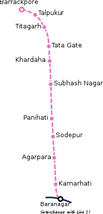
The stations in this line are:[4]
| Line 5 (Pink Line) | ||||||||||
|---|---|---|---|---|---|---|---|---|---|---|
| No. | Station Name | Location | Phase | Opening | Connections | Layout | Platform type | Coordinates | Notes | |
| English | Bengali | |||||||||
| 1 | Baranagar | বরাহনগর | Baranagar | 1 | 22 February 2021 | Baranagar Metro Station of Blue Line (operational) | Elevated | Side | 22°37′23″N 88°25′38″E | Also known as Dunlop Crossing |
| 2 | Kamarhati | কামারহাটি | Kamarhati | Planned | ||||||
| 3 | Agarpara | আগরপাড়া | Agarpara | |||||||
| 4 | Panihati | পানিহাটি | Panihati | |||||||
| 5 | Sodepur | সোদপুর | Sodepur | |||||||
| 6 | Subhash Nagar | সুভাষ নগর | Subhash Nagar | Also known as Sukchar | ||||||
| 7 | Khardaha | খড়দহ | Khardaha | |||||||
| 8 | Tata Gate | টাটা গেট | Titagarh Power Plant | Also known as Vivek Nagar | ||||||
| 9 | Titagarh | টিটাগড় | Titagarh | |||||||
| 10 | Talpukur | তালপুকুর | Talpukur | |||||||
| 11 | Barrackpore | ব্যারাকপুর | Barrackpore | |||||||
Proposed realignment
State government proposed for realigning the line via Kalyani Expressway, instead of B.T. Road, due to the presence of arterial water pipelines, that supply water to the city, below BT Road. The construction might create huge traffic jam along the road and also damage the water pipelines, which will cutoff the city's water supply. This will increase the length to 17 km (10.56 mi). [3][5]
See also
References
- "New System Map of Kolkata Metro".
- CAF to supply Kolkata metro trains, Railway Gazette, 9 September 2012
- Bandyopadhyay, Krishnendu (16 May 2018). "Metro: Metro iffy about state's Barrackpore route plan | Kolkata News - Times of India". The Times of India. Retrieved 28 February 2020.
- TNN. "Mamata paves way for Metro's northern journey". Times of India. Retrieved 12 October 2019.
- "Barrackpore Metro 'detour' to Kalyani". www.telegraphindia.com. Retrieved 28 February 2020.
This article is issued from Wikipedia. The text is licensed under Creative Commons - Attribution - Sharealike. Additional terms may apply for the media files.

