Asoha
Asoha is a village in Purwa tehsil of Unnao district, Uttar Pradesh, India.[2] It is located about 16 km north of Purwa, the tehsil headquarters, and 51 km east of Unnao, the district headquarters.[3] The main crops grown here are wheat, barley, gram, juwar, paddy, and pulses, and irrigation is provided by a canal as well as by tanks.[3] The soil here is mostly clay.[4] As of 2011, the population of Asoha is 3,709, in 856 households.[2]
Asoha
Asohā | |
|---|---|
Village | |
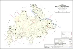 Map of Asoha CD block | |
 Asoha Location in Uttar Pradesh, India | |
| Coordinates: 26.585593°N 80.83518°E[1] | |
| Country India | |
| State | Uttar Pradesh |
| District | Unnao |
| Area | |
| • Total | 3.375 km2 (1.303 sq mi) |
| Population (2011)[2] | |
| • Total | 3,709 |
| • Density | 1,100/km2 (2,800/sq mi) |
| Languages | |
| • Official | Hindi |
| Time zone | UTC+5:30 (IST) |
| Vehicle registration | UP-35 |
Asoha is the headquarters of a community development block, which was first inaugurated on 1 July 1956 in order to oversee implementation of India's Five-Year Plans at a local and rural level.[3] As of 2011, the block comprises 122 rural villages (including Asoha itself), with a total population of 153,798 people in 30,885 households.[2] Asoha is also the headquarters of a nyaya panchayat.[3]
History
According to C.A. Elliott, the name "Asoha" is derived from that of Ashwatthama, the figure in the Mahabharata, who is said to have rested here for a time after the murder of Draupadi's children.[4] Asoha was historically the seat of a pargana, which is first attested during the reign of the Mughal emperor Akbar in the late 16th century.[4] At the turn of the 20th century, Asoha had five temples, a police station, a cattle pound, and a primary school, as well as "unusually extensive" groves of mango and mahua trees.[4]
The 1961 census recorded Asoha as comprising 4 hamlets, with a total population of 1,868 (981 male and 887 female), in 304 households and 286 physical houses.[5] The area of the village was given as 861 acres.[5] It had a police force of 1 sub-inspector, 1 head constable, and 13 constables at the time.[5]
Culture
A legendary figure named Astik is worshipped in Asoha.[3] He is said to have been born during the Dvapara Yuga period,[4] and that at the time of the great Sarpa Satra performed by Janamejaya, Astik received a boon from the serpent Takshak, who promised him that men bitten by snakes would recover if they took his name.[3]
Villages
Asoha CD block has the following 122 villages:[2]
| Village name | Total land area (hectares) | Population (in 2011) |
|---|---|---|
| Kashi Pur | 54.8 | 300 |
| Datauli | 125.5 | 735 |
| Saharawan | 894.5 | 6,211 |
| Keona | 149.4 | 890 |
| Keoni | 182 | 653 |
| Jagdish Pur | 144.7 | 276 |
| Sahabad Grant | 400.2 | 1,475 |
| Beekamau | 216.8 | 1,235 |
| Narsingh Pur | 118.6 | 769 |
| Kantha | 2,155.1 | 9,973 |
| Ratawar | 227.4 | 871 |
| Surja Pur | 151.9 | 1,195 |
| Saraiya | 198 | 1,013 |
| Chaktaliya Bhur | 32.9 | 0 |
| Islam Nagar | 114.6 | 523 |
| Newada | 79.7 | 566 |
| Nimaicha | 115.9 | 607 |
| Sikri | 205.7 | 488 |
| Ajai Pur | 88.3 | 376 |
| Asoha (block headquarters) | 337.5 | 3,709 |
| Pathak Pur | 459 | 3,054 |
| Malla Khera | 67.9 | 555 |
| Gadhi Karmali | 202.6 | 881 |
| Goshain Khera | 487.5 | 1,199 |
| Kushli Khera | 209.7 | 107 |
| Harnam Khera | 252.9 | 347 |
| Ismail Pur | 257.9 | 882 |
| Barha | 72.5 | 638 |
| Gyanpur | 140.2 | 892 |
| Makdumpur | 41.3 | 540 |
| Gaddipur | 63.7 | 33 |
| Darheta Achli | 88.5 | 814 |
| Darheta Mahant | 75.2 | 627 |
| Lachhi Pur | 160.6 | 1,037 |
| Pahar Pur | 164.6 | 1,269 |
| Ograpur | 209.9 | 1,597 |
| Chilauli | 217.8 | 1,165 |
| Gumapur | 170.8 | 946 |
| Pardamanpur | 63.5 | 305 |
| Kilpur | 70.1 | 366 |
| Godwa | 102.8 | 330 |
| Dundiyathar | 163.8 | 798 |
| Bilaura | 325.2 | 2,388 |
| Majharia | 142.5 | 1,096 |
| Chaupai | 533.6 | 2,548 |
| Nim Tikar | 163.3 | 1,227 |
| Semri | 352.6 | 1,980 |
| Utraura | 240.4 | 1,281 |
| Jabrela | 451.4 | 3,004 |
| Karam Semau | 87.1 | 0 |
| Soho | 64 | 1,675 |
| Pahasa | 378 | 1,355 |
| Beru | 140.4 | 975 |
| Muktey Mau | 406.9 | 969 |
| Chhiyantikur | 147.8 | 1,562 |
| Kalu Khera | 101 | 1,888 |
| Bhawalia | 228.1 | 2,177 |
| Bhur Pahas | 99.6 | 0 |
| Rampur | 330.6 | 1,432 |
| Rawat Khera | 71.2 | 394 |
| Kanchanpur | 270 | 1,793 |
| Maliha Garha | 228.1 | 1,216 |
| Anwarpur | 119.6 | 707 |
| Sandoli | 146.5 | 665 |
| Sarwan | 795.5 | 3,824 |
| Baraoli | 302.2 | 894 |
| Terhwa Babhna | 152.2 | 749 |
| Sarwara | 129.9 | 715 |
| Bhao Mau | 176.6 | 1,125 |
| Samadha | 856.9 | 3,681 |
| Sheo Garh | 76.8 | 712 |
| Sikhaiya | 200.5 | 1,157 |
| Barwa Khurd | 183.6 | 693 |
| Bhat Purwa | 147.7 | 961 |
| Gilshah Mau | 135.9 | 689 |
| Shah Pur | 475.5 | 2,342 |
| Mubarkpur | 119.5 | 818 |
| Pipri | 224.8 | 1,777 |
| Darsawan | 473.7 | 3,074 |
| Daun | 714.6 | 2,743 |
| Asawar | 510.1 | 3,080 |
| Zorawar Ganj | 514.2 | 2,553 |
| Jhakwasa | 93.3 | 1,065 |
| Raipura | 64.7 | 308 |
| Rahimanpur Jagdishpur | 283.8 | 714 |
| Saidpur | 142.4 | 750 |
| Abhusha | 170.9 | 1,070 |
| Chhavinath Khera | 66.7 | 403 |
| Mohammdpur | 101.8 | 720 |
| Ajaipur | 90.5 | 617 |
| Talhauri | 137.5 | 1,373 |
| Karauli | 251.9 | 811 |
| Madarpur/Narainpur | 246.6 | 1,254 |
| Ratwsiyana Madarpur | 203.4 | 1,033 |
| Dharampur | 266.9 | 762 |
| Tilokpur | 115.2 | 900 |
| Bachhaura | 312.2 | 1,802 |
| Sariya | 141 | 973 |
| Mirri Khurd | 166.2 | 589 |
| Mirri Kalan | 627.1 | 5,622 |
| Raiker | 63.5 | 448 |
| Bhadin | 395 | 2,212 |
| Manika Pur | 251.6 | 685 |
| Maidpur | 161.3 | 954 |
| Kudikapur | 241.8 | 657 |
| Dhannipur | 171.3 | 759 |
| Dhaurhara | 147.7 | 787 |
| Ibrahimpur | 114.6 | 370 |
| Chaitra | 232.1 | 1,449 |
| Rashidpur | 100.3 | 785 |
| Turi Raja Sahib | 144.2 | 586 |
| Turichhabinath | 116.8 | 594 |
| Raipur | 68.7 | 364 |
| Behta | 199.5 | 1,423 |
| Sumbhari Khurd | 243.4 | 787 |
| Raqba | 46.8 | 284 |
| Mangat Khera | 220.7 | 1,329 |
| Majhkuriya | 74.6 | 1,470 |
| Atarsai | 311.2 | 317 |
| Baigaon | 267.9 | 3,212 |
| Bachhrauli | 202.3 | 949 |
| Kakauha | 78 | 445 |
References
- Search for "Asoha" here https://geonames.nga.mil/namesgaz/.
{{cite web}}: Missing or empty|title=(help) - "Census of India 2011: Uttar Pradesh District Census Handbook - Unnao, Part A (Village and Town Directory)". Census 2011 India. pp. 323–47. Retrieved 9 July 2021.
- Baghel, Amar Singh (1979). Uttar Pradesh District Gazetteers: Unnao. Rampur: Government Press. pp. 150–2, 252. Retrieved 9 July 2021.
- Nevill, H.R. (1903). Unao: A Gazetteer, Being Volume XXXVIII Of The District Gazetteers Of The United Provinces Of Agra And Oudh. Allahabad: Government Press. pp. 147–50. Retrieved 9 July 2021.
- Census 1961: District Census Handbook, Uttar Pradesh (37 - Unnao District) (PDF). Lucknow. 1965. pp. 127, xcvi-xcvii of section "Purwa Tehsil". Retrieved 9 July 2021.
{{cite book}}: CS1 maint: location missing publisher (link)