Miyanganj
Miyanganj, also spelled Mianganj, is a village and corresponding community development block in Hasanganj tehsil of Unnao district, Uttar Pradesh, India.[2] It is located on the road from Lucknow to Bangarmau, just to the west of the crossroads with another route linking Unnao and Sandila.[3]
Miyanganj
Mianganj | |
|---|---|
Town | |
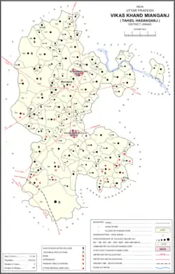 Map of Mianganj CD block | |
 Miyanganj Location in Uttar Pradesh, India | |
| Coordinates: 26.800186°N 80.487958°E[1] | |
| Country India | |
| State | Uttar Pradesh |
| District | Unnao |
| Founded by | Miyan Almas Ali Khan |
| Area | |
| • Total | 3.195 km2 (1.234 sq mi) |
| Population (2011)[2] | |
| • Total | 8,948 |
| • Density | 2,800/km2 (7,300/sq mi) |
| Languages | |
| • Official | Hindi |
| Time zone | UTC+5:30 (IST) |
| Vehicle registration | UP-35 |
Miyanganj hosts a cattle fair on Asadha Badi 2-30.[4] Vendors bring wooden products, agricultural implements, sweets, toys, and assorted other merchandise to sell at the event.[4] The village also hosts a market on Wednesdays and Saturdays where grain and vegetables are sold.[4] As of 2011, its population is 8,948, in 1,575 households.[2]
History
Formerly a village called Bhopatpur, the modern settlement of Miyanganj was founded in 1771 by Miyan Almas Ali Khan, a eunuch and finance minister under the Nawabs of Awadh.[3] It was described in 1803 as a prosperous town, but then in 1823 a visitor described it as rapidly becoming dilapidated.[3] It was later the site of a battle during the Indian Rebellion of 1857.[3]
At the turn of the 20th century, Miyanganj had 13 mosques, 4 temples, two sarais, and one primary school with 33 students.[3] The population in 1901 was 3,395 residents, including 1,312 Muslims, an especially high proportion for this part of Awadh.[3]
The 1961 census recorded Miyanganj (here spelled "Miaganj") as comprising 3 hamlets, with a total population of 2,885 (1,503 male and 1,382 female), in 511 households and 493 physical houses.[4] The area of the village was given as 836 acres.[4] Average attendance of the cattle fair was about 4,000 people, and attendance of biweekly market averaged about 800.[4] The V.D.T. Higher Secondary School in Miyanganj, founded in 1950, was in 1961 recorded as having a faculty of 10 teachers (all male) and a student body of 284 (also all male).[4]
Villages
Miyanganj CD block has the following 140 villages:[2]
| Village name | Total land area (hectares) | Population (in 2011) |
|---|---|---|
| Shiva Thana | 217.4 | 1,407 |
| Anee Khurd | 222.4 | 1,745 |
| Himmat Khera | 320.7 | 2,447 |
| Tiyar | 76 | 844 |
| Subhami Khera | 66.2 | 752 |
| Tikara | 110.7 | 572 |
| Newada | 62.1 | 390 |
| Durga Gadhi | 107.2 | 398 |
| Gobari | 178.6 | 1,323 |
| Shyampur | 120.9 | 872 |
| Galrapur | 162.5 | 1,362 |
| Chakbaresar | 213.4 | 1,285 |
| Aini Bujurg | 166.3 | 827 |
| Beejeemau | 270.8 | 2,299 |
| Kulha Ataora | 794.1 | 4,010 |
| Suman Khera | 88.8 | 649 |
| Murbbatpur | 111 | 1,021 |
| Mujaffarpur Sarra | 324.7 | 2,457 |
| Sareefabad | 106.6 | 486 |
| Dewasapur | 87.2 | 536 |
| Makhdampur Sahasafi | 44 | 665 |
| Malheemau | 121.4 | 758 |
| Jalalabad | 45.4 | 252 |
| Khanpur Peer Ali | 137.8 | 889 |
| Jahangeer Nagar | 72.5 | 637 |
| Khairanpur Gawasa | 123 | 740 |
| Kanigaon | 425.6 | 2,794 |
| Asiwantaraf Aima | 84.4 | 0 |
| Asiwantaraf Katra | 47 | 565 |
| Asiwantaraf Lokman | 200.5 | 2,813 |
| Asiwantraph Kadirpur | 188.8 | 2,526 |
| Jamalpur | 254.6 | 1,139 |
| Asiwantraph Chak Chamrosi | 43 | 0 |
| Asiwantraph Pashchim | 533.8 | 6,089 |
| Asiwantraph Nai Basti | 157.6 | 1,532 |
| Asiwantraph Sidhnath | 539.7 | 1,795 |
| Asiwantaraph | 141.2 | 1,445 |
| Miyanganj (block headquarters) | 319.5 | 8,948 |
| Saramba | 465.6 | 1,772 |
| Gorakala | 247.1 | 1,558 |
| Nauhai Khurd | 125.6 | 1,022 |
| Nauhai Bujurg | 100 | 734 |
| Binaika | 215.5 | 1,222 |
| Bala Khera | 106.6 | 451 |
| Haiderabad | 359.9 | 91 |
| Parasaifpur | 181 | 1,328 |
| Sahbasi | 97.6 | 950 |
| Barha Kalan | 312.6 | 2,169 |
| Gengla Mau | 111.9 | 658 |
| Rampur Kala | 84.8 | 607 |
| Banaoni | 117.4 | 619 |
| Firojpur Ramai | 66.2 | 526 |
| Basorwa Mohammadpur | 164.6 | 1,016 |
| Malholi Sardarnagar | 209.4 | 1,381 |
| Pathakpur | 208.2 | 1,412 |
| Chhitepur | 61 | 504 |
| Aladadpur | 14.5 | 0 |
| Udhranmau | 161.8 | 0 |
| Darihat | 129.8 | 971 |
| Ahamadpur Taktouli | 180.4 | 1,003 |
| Nepalpur | 235.2 | 1,206 |
| Shahijana Jargar | 83.6 | 509 |
| Sundhari Khurd | 134.4 | 879 |
| Akbarpur | 219.2 | 1,273 |
| Rajapur | 187.4 | 593 |
| Fakhruddeenmau | 202.1 | 1,048 |
| Salenagar | 75.6 | 416 |
| Kotaraha | 67.3 | 387 |
| Asrenda | 103.2 | 310 |
| Mishrapur | 43.1 | 289 |
| Sarang Har | 65.7 | 216 |
| Mahendra | 101.6 | 959 |
| Kamlpur | 150.5 | 669 |
| Budhanpur | 70.8 | 733 |
| Madarpur Kaolai | 308 | 1,150 |
| Bhitwa | 71.4 | 304 |
| Mahmudpur | 67.4 | 398 |
| Nijampur | 86.7 | 259 |
| Shahabad | 108.2 | 430 |
| Aorai | 111.8 | 574 |
| Rasulabad | 544.4 | 0 |
| Gaora Khurd | 139.4 | 512 |
| Nurulla Nagar | 529 | 2,403 |
| Atiya | 74.6 | 425 |
| Karhiya | 75.7 | 430 |
| Mirjapur Kala | 162.3 | 1,801 |
| Bhangarwat | 176.4 | 1,182 |
| Laglesrapur | 122.5 | 375 |
| Mawai Brahmanan | 504.2 | 2,211 |
| Siras Kanhar | 39 | 710 |
| Siras Chere | 173.6 | 737 |
| Tajpur | 93.9 | 1,037 |
| Bhakhra Khera | 91.3 | 250 |
| Ahmadpur | 116.1 | 656 |
| Sahajanpur | 112.5 | 476 |
| Mohaliya | 144 | 610 |
| Shahpur Sindhora | 131.4 | 1,099 |
| Panapur Kala | 164.8 | 1,130 |
| Laglaisra | 80.9 | 1,297 |
| Sirepur | 103.4 | 300 |
| Ariyar Kala | 136.6 | 983 |
| Kuremu | 102.3 | 736 |
| Ariyar Khurd | 94.7 | 729 |
| Naogawan | 32.3 | 192 |
| Lachha Khera | 45.2 | 310 |
| Salempur | 467.5 | 2,688 |
| Korari Khurd | 131.4 | 1,411 |
| Rana Gadhi | 110 | 878 |
| Korari Kala | 702.7 | 4,218 |
| Tenai | 141.9 | 901 |
| Purwa | 890 | 3,088 |
| Birampur | 150.2 | 973 |
| Paigambarpur | 153.3 | 507 |
| Hari Gadhi | 136.2 | 666 |
| Pama Khera | 131.4 | 554 |
| Basawan Khera | 14 | 0 |
| Kotra | 497.6 | 1,601 |
| Jangal Jahanabad | 221.2 | 735 |
| Makhi | 2,216.8 | 13,786 |
| Biru Gadhi | 403 | 1,705 |
| Vajid Nagar | 80 | 491 |
| Konai | 60.5 | 517 |
| Mustafabad | 404 | 2,620 |
| Hamirpur | 214 | 910 |
| Rawatpur | 253.1 | 602 |
| Saraoha | 190 | 1,063 |
| Ahra Dandiya | 240 | 1,728 |
| Sarai Chandan | 151 | 733 |
| Dayalpur | 46.7 | 85 |
| Nisbhi | 103.7 | 620 |
| Bajehra | 76 | 479 |
| Selai | 54 | 758 |
| Bhaduha | 179 | 798 |
| Amethan Gadhi | 129.9 | 1,108 |
| Parenda | 447 | 2,237 |
| Bhawaneepur | 66.4 | 697 |
| Dipa Gadhi | 218.7 | 1,500 |
| Jareliya | 136.4 | 506 |
| Champat Pur | 183.3 | 1,191 |
| Ograpur | 62.8 | 420 |
References
- "Geographic Names Search WebApp". Search for "Miyanganj" here.
- "Census of India 2011: Uttar Pradesh District Census Handbook - Unnao, Part A (Village and Town Directory)". Census 2011 India. pp. 178–203. Retrieved 30 June 2021.
- Nevill, H.R. (1903). Unao: A Gazetteer, Being Volume XXXVIII Of The District Gazetteers Of The United Provinces Of Agra And Oudh. Allahabad: Government Press. pp. 203–4. Retrieved 30 June 2021.
- Census 1961: District Census Handbook, Uttar Pradesh (37 - Unnao District) (PDF). Lucknow. 1965. pp. 133, 152–3, 156, xliv-xlv of section "Hasanganj Tehsil". Retrieved 2 July 2021.
{{cite book}}: CS1 maint: location missing publisher (link)