Utraura
Utraura is a village in Asoha block of Unnao district, Uttar Pradesh, India.[2] It is not located on major district roads and has one primary school and no healthcare facilities.[2] As of 2011, its population is 1,281, in 281 households.[2]
Utraura | |
|---|---|
Village | |
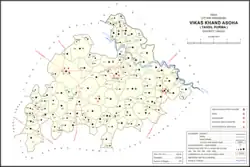 Map showing Utraura (#444) in Asoha CD block | |
 Utraura Location in Uttar Pradesh, India | |
| Coordinates: 26.590217°N 80.898136°E[1] | |
| Country India | |
| State | Uttar Pradesh |
| District | Unnao |
| Area | |
| • Total | 2.404 km2 (0.928 sq mi) |
| Population (2011)[2] | |
| • Total | 1,281 |
| • Density | 530/km2 (1,400/sq mi) |
| Languages | |
| • Official | Hindi |
| Time zone | UTC+5:30 (IST) |
| Vehicle registration | UP-35 |
The 1961 census recorded Utraura as comprising 2 hamlets, with a total population of 997 (522 male and 475 female), in 102 households and 92 physical houses.[3] The area of the village was given as 582 acres.[3] It had one small manufacturer of textiles as well as a small establishment classified as making jewellery or precious metal items.[3]
References
- "Do a radial search using these coordinates here". geonames.nga.mil. Archived from the original on 12 April 2014. Retrieved 12 April 2023.
- "Census of India 2011: Uttar Pradesh District Census Handbook - Unnao, Part A (Village and Town Directory)". Census 2011 India. pp. 323–47. Retrieved 9 July 2021.
- Census 1961: District Census Handbook, Uttar Pradesh (37 - Unnao District) (PDF). Lucknow. 1965. pp. xcviii-xcviv of section "Purwa Tehsil", cxxvi–cxxvii. Retrieved 9 July 2021.
{{cite book}}: CS1 maint: location missing publisher (link)
This article is issued from Wikipedia. The text is licensed under Creative Commons - Attribution - Sharealike. Additional terms may apply for the media files.