Central Sumba Regency
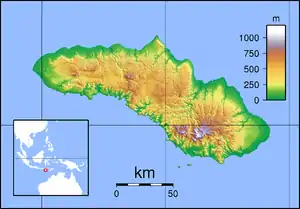
Central Sumba Regency (Indonesian: Kabupaten Sumba Tengah) is a regency in East Nusa Tenggara of Indonesia. The new Central Sumba Regency was established on the island of Sumba when West Sumba Regency was split into two regencies on 22 May 2007 and a further Regency was created in Central Sumba from parts of both West Sumba and East Sumba Regencies.[2] The new Regency covers 2,060.54 km2 and had a population of 62,485 at the 2010 Census[3] and 85,482 at the 2020 Census;[4] the official estimate as at mid 2022 was 90,482.[1] The seat (capital) of its government is located at Waibakul.
Central Sumba Regency
Kabupaten Sumba Tengah | |
|---|---|
 Coat of arms | |
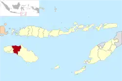 Location within East Nusa Tenggara | |
 Central Sumba Regency  Central Sumba Regency Central Sumba Regency (Lesser Sunda Islands)  Central Sumba Regency Central Sumba Regency (Indonesia) | |
| Coordinates: 9.6294°S 119.6191°E | |
| Country | |
| Region | Lesser Sunda Islands |
| Province | |
| Capital | Waibakul |
| Government | |
| • Regent | Umbu Sappi Pateduk |
| • Vice Regent | Umbu Dondu |
| Area | |
| • Total | 795.58 sq mi (2,060.54 km2) |
| Population (mid 2022 estimate)[1] | |
| • Total | 90,482 |
| • Density | 110/sq mi (44/km2) |
| Area code | (+62) 386 |
| Website | sumbatengahkab |
Administrative Districts
The Central Sumba Regency (following the re-organisation of 22 May 2007 which created it out of parts of both West Sumba Regency and East Sumba Regency) was composed of five districts (kecamatan), but a sixth district (Umbu Ratu Nggay Tengah) has been created by taking 7 villages from Umbu Ratu Nggay District and 3 villages from West Umbu Ratu Nggay District. The areas (in km2) and populations of these districts at the 2010 Census[3] and the 2020 Census[4] are listed below, together with the official estimates as at mid 2022.[1] The table also includes the locations of the district administrative centres, the number of administrative villages in each district (rural desa and urban kelurahan), and its postal code.
| Name of District (kecamatan) | Area in km2 | Pop'n Census 2010 | Pop'n Census 2020 | Pop'n Estimate mid 2022 | Admin centre | No. of villages | Post code |
|---|---|---|---|---|---|---|---|
| Katikutana | 78.83 | 9,733 | 13,837 | 14,753 | Anakalang | 7 | 87282 |
| Katikutana Selatan (South Kalikutana) | 368.34 | 10,095 | 14,755 | 15,817 | Waikabeti | 9 | 87280 |
| Umbu Ratu Nggay Barat (West Umbu Ratu Nggay) | (a) 272.05 | 16,223 | 21,507 | 19,533 | Maderi | 15 | 87281 |
| Umbu Ratu Nggay | (a) 791.37 | 12,264 | 16,306 | 11,856 | Lendi Wacu | 11 | 87283 |
| Umbu Ratu Nggay Tengah (Central Umbu Ratu Nggay) | 191.36 | (b) | (b) | 8,396 | Bolubokat | 10 | 87283 |
| Mamboro | 358.59 | 14,170 | 19,077 | 20,127 | Mananga | 13 | 87258 |
| Totals | 2,060.54 | 62,485 | 85,482 | 90,482 | Waibakul | 65 |
Note: (a) This area has subsequently been reduced by the creation of the new Central Umbu Nggay District. (b) The populations at the 2010 and 2020 Censuses of the villages now forming the new Central Umbu Ratu Nggay District are included with the figures for the two districts from which they were cut out.
References
- Badan Pusat Statistik, Jakarta, 2023, Kabupaten Sumba Tengah Dalam Angka 2023 (Katalog-BPS 1102001.5317)
- Government of Indonesia (2 January 2007), Establishment of Central Sumba Regency in the East Nusa Tenggara province (PDF) (in Indonesian), Indonesia Ministry of Law and Justice, UU No. 3/2007, retrieved 2007-08-24
- Biro Pusat Statistik, Jakarta, 2011.
- Badan Pusat Statistik, Jakarta, 2021.
