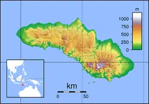
West Sumba Regency
West Sumba Regency (Indonesian: Kabupaten Sumba Barat) is a regency in East Nusa Tenggara Province of Indonesia. Established in 1958,[2] the regency was considerably reduced on 22 May 2007 with the creation of new Regencies on Sumba Island under Law UU No.16 of that year. Its area is now 737.42 km2, and its population was 110,993 at the 2010 census[3] and 145,097 at the 2020 Census;[4] the official estimate as at mid 2022 was 152,407.[1] It has its seat (capital) in (Kota) Waikabubak.
West Sumba Regency
Kabupaten Sumba Barat | |
|---|---|
 Coat of arms | |
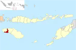 Location within East Nusa Tenggara | |
 West Sumba Regency  West Sumba Regency West Sumba Regency (Lesser Sunda Islands)  West Sumba Regency West Sumba Regency (Indonesia) | |
| Coordinates: 9.5667°S 119.4500°E | |
| Country | |
| Region | Lesser Sunda Islands |
| Province | |
| Capital | Waikabubak |
| Government | |
| • Regent | Agustinus Niga Dapawole |
| • Vice Regent | Marthen Ngailu Toni |
| Area | |
| • Total | 284.72 sq mi (737.42 km2) |
| Population (mid 2022 estimate)[1] | |
| • Total | 152,407 |
| • Density | 540/sq mi (210/km2) |
| Time zone | UTC+8 (ICST) |
| Area code | (+62) 387 |
| Website | sumbabaratkab |
The region is rather dry. One of the main problems for people living in rural areas in the province is frequent shortages of water. Although there are some local supplies of water from wells and springs, water from these sources often becomes scarce during the long dry seasons. In some villages local non-government organisations, some supported with international assistance, support small projects to improve village water supplies.[5]
Administrative Districts
The West Sumba Regency (following the re-organisation in 2007 which created Southwest Sumba Regency and Central Sumba Regency out of parts of West Sumba Regency) is now composed of six districts (kecamatan), whose areas (in km2) and populations at the 2010 Census[3] and 2020 Census,[4] are listed below, together with the official estimates as at mid 2022.[1] The table also includes the locations of the district headquarters, the number of administrative villages in each district (totaling 63 rural desa and 11 urban kelurahan), and its postal code.
| Name of District (kecamatan) | Area in km2 | Pop'n Census 2010 | Pop'n Census 2020 | Pop'n Estimate mid 2022 | Admin centre | No. of villages | Post code |
|---|---|---|---|---|---|---|---|
| Lamboya | 125.65 | 15,856 | 22,059 | 23,431 | Kabukarudi | 11 | 87271 |
| Wanokata | 133.68 | 14,163 | 18,811 | 19,802 | Pogo Katoda | 14 | 87272 |
| Laboya Barat (West Laboya) | 161.23 | 7,327 | 8,815 | 9,104 | Hodi | 4 | 87270 |
| Loli | 132.36 | 27,103 | 38,932 | 41,610 | Dokakaka | 14 (a) | 87284 |
| Kota Waikabubak (Waikabubak town) | 44.71 | 28,874 | 33,064 | 33,821 | Waikabubak | 13 (b) | 87211 - 87217 |
| Tana Righu | 139.79 | 17,670 | 23,416 | 24,639 | Malata | 18 | 87257 |
| Totals | 737.42 | 110,993 | 145,097 | 152,407 | Waikabubak | 74 |
Notes: (a) comprising 5 kelurahan and 9 desa. (b) comprising 6 kelurahan and 7 desa.
Villages
Villages in the area include:
- Tarung
- Waitabar
- Bodo Ede
- Bodomaroto
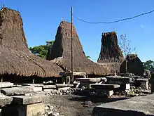 Traditional houses in Tarung-Waitabar village
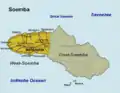 Map of Sumba Island, showing West Sumba Regency prior to the creation in 2007 of the new Southwest Sumba Regency and Central Sumba Regency from parts of West Sumba Regency.
Tourism
In 2016 and 2017 Travel + Leisure magazine gave the title of World's Best Hotel (with the highest 98.35 score based on readers' choice) to Nihiwatu Resort (now known as Nihi Sumba[6]). The hotel is one of the leading sectors for ecotourism.[7]
Climate
Waikabubak has a tropical monsoon climate (Am) with moderate to little rainfall from June to September and heavy to very heavy rainfall from October to May.
| Climate data for Waikabubak | |||||||||||||
|---|---|---|---|---|---|---|---|---|---|---|---|---|---|
| Month | Jan | Feb | Mar | Apr | May | Jun | Jul | Aug | Sep | Oct | Nov | Dec | Year |
| Average high °C (°F) | 28.9 (84.0) |
28.4 (83.1) |
28.9 (84.0) |
29.3 (84.7) |
28.9 (84.0) |
28.2 (82.8) |
28.1 (82.6) |
28.6 (83.5) |
29.4 (84.9) |
30.0 (86.0) |
29.6 (85.3) |
29.2 (84.6) |
29.0 (84.1) |
| Daily mean °C (°F) | 23.7 (74.7) |
23.5 (74.3) |
23.8 (74.8) |
23.7 (74.7) |
23.1 (73.6) |
22.2 (72.0) |
21.7 (71.1) |
21.9 (71.4) |
22.9 (73.2) |
23.9 (75.0) |
24.4 (75.9) |
24.1 (75.4) |
23.2 (73.8) |
| Average low °C (°F) | 18.6 (65.5) |
18.6 (65.5) |
18.7 (65.7) |
18.2 (64.8) |
17.4 (63.3) |
16.3 (61.3) |
15.3 (59.5) |
15.3 (59.5) |
16.4 (61.5) |
17.9 (64.2) |
19.2 (66.6) |
19.0 (66.2) |
17.6 (63.6) |
| Average rainfall mm (inches) | 415 (16.3) |
365 (14.4) |
375 (14.8) |
258 (10.2) |
181 (7.1) |
63 (2.5) |
48 (1.9) |
30 (1.2) |
76 (3.0) |
151 (5.9) |
292 (11.5) |
405 (15.9) |
2,659 (104.7) |
| Source: Climate-Data.org[8] | |||||||||||||
References
- Badan Pusat Statistik, Jakarta, 2023, Kabupaten Sumba Barat Dalam Angka 2023 (Katalog-BPS 1102001.5312)
- Government of Indonesia (9 August 1958), Establishment of the Second-level Administrative Regions under the First-level Administrative Region of Bali, West Nusa Tenggara and East Nusa Tenggara (in Indonesian), Indonesia Ministry of Law and Justice, UU No. 69/1958, retrieved 2007-08-24
- Biro Pusat Statistik, Jakarta, 2011.
- Badan Pusat Statistik, Jakarta, 2021.
- Emanual Dapa Loka (27 April 2012). "Andrew Graff: Taking initiative in West Sumba". The Jakarta Post.
- Once in a Lifetime Journey (10 September 2017). "Nihi Sumba Hotel Review, the Best Hotel in the World".
- "Nihiwatu Resort Sumba Terpilih Sebagai Hotel Terbaik Dunia". July 19, 2016.
- "Climate: Waikabubak". Climate-Data.org. Retrieved 17 November 2020.
External links
Regencies and cities of East Nusa Tenggara | ||
|---|---|---|
Capital: Kupang | ||
| Regencies |  | |
| Cities | ||