Manggarai Regency
Manggarai Regency is a regency in East Nusa Tenggara province of Indonesia, situated on the island of Flores. Established in 1958[2] the regency was reduced in size and population by the separation of Manggarai Barat regency in 2003 and of Manggarai Timur regency in 2007. The area of the residual Manggarai Regency is 1,344.03 km2 and its population was 292,037 at the 2010 census[3] and 312,855 at the 2020 census;[4] the official estimate as at mid 2022 was 317,646.[1] The capital of the regency is the town of Ruteng.
Manggarai Regency
Kabupaten Manggarai | |
|---|---|
 Coat of arms | |
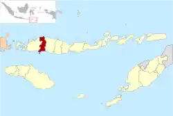 Location within East Nusa Tenggara | |
 Manggarai Regency  Manggarai Regency Manggarai Regency (Lesser Sunda Islands)  Manggarai Regency Manggarai Regency (Indonesia) | |
| Coordinates: 8.6127°S 120.4626°E | |
| Country | |
| Province | |
| Capital | Ruteng |
| Government | |
| • Regent | Deno Kamelus |
| • Vice Regent | Victor Madur |
| Area | |
| • Total | 518.93 sq mi (1,344.03 km2) |
| Population (mid 2022 estimate)[1] | |
| • Total | 317,646 |
| • Density | 610/sq mi (240/km2) |
| Area code | (+62) 385 |
| Website | manggaraikab |
The Liang Bua archeological site is in Manggarai regency, about 10 km to the north of Ruteng.
Administrative districts
Manggarai Regency was one of the original regencies of East Nusa Tenggara Province, but was reduced in area and population on 25 February 2003 when some of its western districts were split off to form the West Manggarai Regency, and then again on 17 July 2007 when some eastern districts were split off to form the East Manggarai Regency. The remaining Manggarai Regency as at 2010 was divided into nine districts (kecamatan), but since 2010 three additional districts – Cibal Barat, Reok Barat and subsequently Satar Mese Utara – have been created by splitting of existing districts. The districts are tabulated below with their areas and their populations at the 2010 census[3] and the 2020 census,[4] together with the official estimates as at mid 2022.[1] The table also includes the locations of the district administrative centres, the number of administrative villages (rural desa and urban kelurahan) in each district, and its postal codes.
| Name of District (kecamatan) | Area in km2 | Pop'n census 2010 | Pop'n census 2020 | Pop'n estimate mid 2022 | Admin centre | No. of vill. | Post codes |
|---|---|---|---|---|---|---|---|
| Satar Merse | 191.56 | 30,583 | 33,917 | 34,700 | Iteng | 23 | 86561 |
| Satar Mese Barat (West Satar Mese) (a) | 128.18 | 30,044 | 18,944 | 19,100 | Narang | 12 | 86560 |
| Satar Mese Utara (North Satar Mese) | 114.76 | (b) | 14,854 | 15,500 | Langke Majok | 11 | 86562 |
| Langke Rembong | 38.81 | 66,364 | 65,626 | 65,700 | Ruteng | 20 | 86511 - 86519 |
| Ruteng | 87.36 | 38,888 | 41,533 | 42,100 | Cancar | 19 | 86523 |
| Wae Rii | 83.27 | 25,596 | 28,788 | 29,500 | Timung | 17 | 86594 |
| Lelak | 41.44 | 10,820 | 12,111 | 12,400 | Rejeng | 10 | 86521 |
| Rahung Utara (North Rahong) | 84.59 | 20,659 | 22,180 | 22,500 | Purang | 12 | 86522 |
| Cibal | 89.72 | 37,800 | 25,569 | 24,700 | Pagal | 17 | 86591 |
| Cibal Barat (West Cibal) | 76.26 | (c) | 15,111 | 16,700 | Golo Woi | 10 | 86590 |
| Reok | 151.81 | 31,697 | 19,291 | 19,600 | Reo | 10 | 86592 |
| Reok Barat (West Reok) | 256.27 | (d) | 14,931 | 15,200 | Sambi | 10 | 86593 |
| Totals | 1,344.03 | 292,451 | 312,855 | 317,646 | Ruteng | 171 |
Notes: (a) including the island of Pulau Mules off the south coast of Flores Island. (b) the 2010 population of Satar Mese Utara is included with the figure for Satar Mese Barat District. (c) the 2010 population of Cibal Barat is included with the figure for Cibal District. (d) the 2010 population of Reok Barat is included with the figure for Reok District; these two districts are situated in the north of the regency.
References
- Badan Pusat Statistik, Jakarta, 2023, Kabupaten Manggarai Dalam Angka 2023 (Katalog-BPS 1102001.5310)
- Government of Indonesia (9 August 1958), Establishment of the Second-level Administrative Regions under the First-level Administrative Region of Bali, West Nusa Tenggara and East Nusa Tenggara (in Indonesian), Indonesia Ministry of Law and Justice, UU No. 69/1958
- Biro Pusat Statistik, Jakarta, 2011.
- Badan Pusat Statistik, Jakarta, 2021.
Regencies and cities of East Nusa Tenggara | ||
|---|---|---|
Capital: Kupang | ||
| Regencies |  | |
| Cities | ||
[] ruteng