Lesterps
Lesterps (French pronunciation: [letɛʁ]; L'Esterp in Limousin, an Occitan dialect) is a commune in the Charente department in southwestern France.
Lesterps | |
|---|---|
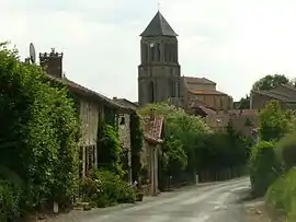 Entering Lesterps from Confolens | |
.svg.png.webp) Coat of arms | |
Location of Lesterps | |
 Lesterps  Lesterps | |
| Coordinates: 46°00′41″N 0°46′53″E | |
| Country | France |
| Region | Nouvelle-Aquitaine |
| Department | Charente |
| Arrondissement | Confolens |
| Canton | Charente-Vienne |
| Intercommunality | Charente Limousine |
| Government | |
| • Mayor (2020–2026) | Daniel Soupizet[1] |
| Area 1 | 36.03 km2 (13.91 sq mi) |
| Population | 444 |
| • Density | 12/km2 (32/sq mi) |
| Time zone | UTC+01:00 (CET) |
| • Summer (DST) | UTC+02:00 (CEST) |
| INSEE/Postal code | 16182 /16420 |
| Elevation | 170–275 m (558–902 ft) (avg. 260 m or 850 ft) |
| 1 French Land Register data, which excludes lakes, ponds, glaciers > 1 km2 (0.386 sq mi or 247 acres) and river estuaries. | |
The inhabitants are called Lesterrois and Lesterroises.
Geography
Lesterps is located in Charente Limousin, in the north-east of the Charente department and borders Haute-Vienne. The village of Lesterps, 9 km east of Confolens, is a major market town. It is 16 km from Chabanais, 17 km from Saint-Junien, 42 km from Limoges and 63 km from Angoulême.
The town is well served by roads. The D30, from Confolens to Limoges via Saint-Junien, crosses it from west to east, and the D29, from Saulgond to Brillac, crosses it from south to north. The D82 east of the village goes to Limoges via Saint-Christophe. The nearest train station is Chabanais, served by TER to Angoulême and Limoges.
Population
|
|
See also
References
- "Répertoire national des élus: les maires". data.gouv.fr, Plateforme ouverte des données publiques françaises (in French). 9 August 2021.
- "Populations légales 2020". The National Institute of Statistics and Economic Studies. 29 December 2022.