Saint-Christophe, Charente
Saint-Christophe (French pronunciation: [sɛ̃ kʁistɔf]; Occitan: Sent Crestòfa) is a commune in the Charente department in southwestern France. It is a member of the Charente Limousine group of coummunes bordering Haute-Vienne. It is located 14 km from Confolens and 67 km northeast of Angoulême .
Saint-Christophe | |
|---|---|
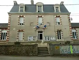 Town hall | |
Location of Saint-Christophe | |
 Saint-Christophe  Saint-Christophe | |
| Coordinates: 46°00′13″N 0°51′03″E | |
| Country | France |
| Region | Nouvelle-Aquitaine |
| Department | Charente |
| Arrondissement | Confolens |
| Canton | Charente-Vienne |
| Intercommunality | Charente Limousine |
| Government | |
| • Mayor (2020–2026) | Patrick Rousseau[1] |
| Area 1 | 23.65 km2 (9.13 sq mi) |
| Population | 314 |
| • Density | 13/km2 (34/sq mi) |
| Time zone | UTC+01:00 (CET) |
| • Summer (DST) | UTC+02:00 (CEST) |
| INSEE/Postal code | 16306 /16420 |
| Elevation | 199–340 m (653–1,115 ft) (avg. 279 m or 915 ft) |
| 1 French Land Register data, which excludes lakes, ponds, glaciers > 1 km2 (0.386 sq mi or 247 acres) and river estuaries. | |
The village is also 5 km east of Lesterps , 13 km north of Saint-Junien , 18 km north-east of Chabanais , 21 km south-west of Bellac and 37 km north- west of Limoges [ 2 ] .
The main road in the commune is the D 82 route from Confolens and Lesterps to Limoges via Oradour-sur-Glane , which crosses it from west to east. The village is also served by the D 163 which goes south-west to Chabanais, and the D 330 south to Brigueuil and Saint-Junien [ 3 ] .
The nearest station is Saint-Junien , served by TER trains to Angoulême and Limoges .
Population
|
|
See also
References
- "Répertoire national des élus: les maires" (in French). data.gouv.fr, Plateforme ouverte des données publiques françaises. 13 September 2022.
- "Populations légales 2020". The National Institute of Statistics and Economic Studies. 29 December 2022.