Saint-Simon, Charente
Saint-Simon (French pronunciation: [sɛ̃ simɔ̃]) is a commune in the Charente department in southwestern France.
Saint-Simon | |
|---|---|
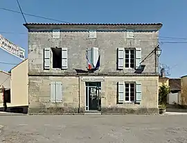 The city hall is a local museum too | |
 Coat of arms | |
Location of Saint-Simon | |
 Saint-Simon  Saint-Simon | |
| Coordinates: 45°39′02″N 0°04′29″W | |
| Country | France |
| Region | Nouvelle-Aquitaine |
| Department | Charente |
| Arrondissement | Cognac |
| Canton | Charente-Champagne |
| Intercommunality | CA Grand Cognac |
| Government | |
| • Mayor (2020–2026) | Jean-Jacques Delage[1] |
| Area 1 | 3.77 km2 (1.46 sq mi) |
| Population | 223 |
| • Density | 59/km2 (150/sq mi) |
| Time zone | UTC+01:00 (CET) |
| • Summer (DST) | UTC+02:00 (CEST) |
| INSEE/Postal code | 16352 /16120 |
| Elevation | 15–53 m (49–174 ft) (avg. 20 m or 66 ft) |
| 1 French Land Register data, which excludes lakes, ponds, glaciers > 1 km2 (0.386 sq mi or 247 acres) and river estuaries. | |
Population
|
|
See also
References
- "Répertoire national des élus: les maires". data.gouv.fr, Plateforme ouverte des données publiques françaises (in French). 2 December 2020.
- "Populations légales 2020". The National Institute of Statistics and Economic Studies. 29 December 2022.
Wikimedia Commons has media related to Saint-Simon (Charente).
This article is issued from Wikipedia. The text is licensed under Creative Commons - Attribution - Sharealike. Additional terms may apply for the media files.