Montdardier
Montdardier (French pronunciation: [mɔ̃daʁdje]; Occitan: Montdardièr) is a commune in the Gard department in southern France.
Montdardier | |
|---|---|
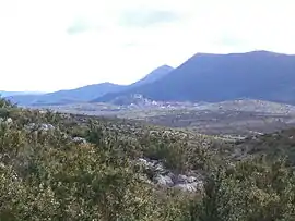 Montdardier and the Tude forest | |
.svg.png.webp) Coat of arms | |
Location of Montdardier | |
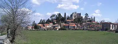
 Montdardier  Montdardier | |
| Coordinates: 43°55′42″N 3°35′33″E | |
| Country | France |
| Region | Occitania |
| Department | Gard |
| Arrondissement | Le Vigan |
| Canton | Le Vigan |
| Intercommunality | Pays viganais |
| Government | |
| • Mayor (2020–2026) | Thierry Redon[1] |
| Area 1 | 35.25 km2 (13.61 sq mi) |
| Population | 191 |
| • Density | 5.4/km2 (14/sq mi) |
| Time zone | UTC+01:00 (CET) |
| • Summer (DST) | UTC+02:00 (CEST) |
| INSEE/Postal code | 30176 /30120 |
| Elevation | 259–889 m (850–2,917 ft) |
| 1 French Land Register data, which excludes lakes, ponds, glaciers > 1 km2 (0.386 sq mi or 247 acres) and river estuaries. | |
Geography
Climate
Montdardier has a warm-summer Mediterranean climate (Köppen climate classification Csb) closely bordering on a hot-summer Mediterranean climate (Csa). The average annual temperature in Montdardier is 12.9 °C (55.2 °F). The average annual rainfall is 1,487.0 mm (58.54 in) with October as the wettest month. The temperatures are highest on average in July, at around 21.9 °C (71.4 °F), and lowest in January, at around 5.3 °C (41.5 °F). The highest temperature ever recorded in Montdardier was 40.3 °C (104.5 °F) on 28 June 2019; the coldest temperature ever recorded was −13.0 °C (8.6 °F) on 27 February 2018.
| Climate data for Montdardier (1991−2020 normals, extremes 2010−present) | |||||||||||||
|---|---|---|---|---|---|---|---|---|---|---|---|---|---|
| Month | Jan | Feb | Mar | Apr | May | Jun | Jul | Aug | Sep | Oct | Nov | Dec | Year |
| Record high °C (°F) | 20.7 (69.3) |
22.2 (72.0) |
25.2 (77.4) |
28.8 (83.8) |
30.1 (86.2) |
40.3 (104.5) |
35.9 (96.6) |
38.0 (100.4) |
32.9 (91.2) |
29.3 (84.7) |
22.8 (73.0) |
19.1 (66.4) |
40.3 (104.5) |
| Average high °C (°F) | 8.9 (48.0) |
9.8 (49.6) |
13.2 (55.8) |
16.2 (61.2) |
19.7 (67.5) |
24.7 (76.5) |
27.9 (82.2) |
27.8 (82.0) |
23.2 (73.8) |
17.6 (63.7) |
12.2 (54.0) |
9.8 (49.6) |
17.6 (63.7) |
| Daily mean °C (°F) | 5.3 (41.5) |
5.5 (41.9) |
8.6 (47.5) |
11.5 (52.7) |
14.6 (58.3) |
19.1 (66.4) |
21.9 (71.4) |
21.7 (71.1) |
17.9 (64.2) |
13.5 (56.3) |
8.9 (48.0) |
6.4 (43.5) |
12.9 (55.2) |
| Average low °C (°F) | 1.6 (34.9) |
1.2 (34.2) |
4.0 (39.2) |
6.8 (44.2) |
9.4 (48.9) |
13.5 (56.3) |
15.9 (60.6) |
15.6 (60.1) |
12.6 (54.7) |
9.3 (48.7) |
5.6 (42.1) |
3.0 (37.4) |
8.2 (46.8) |
| Record low °C (°F) | −9.5 (14.9) |
−13.0 (8.6) |
−3.4 (25.9) |
−4.0 (24.8) |
1.0 (33.8) |
6.1 (43.0) |
8.9 (48.0) |
8.5 (47.3) |
4.2 (39.6) |
−1.5 (29.3) |
−6.4 (20.5) |
−8.5 (16.7) |
−13.0 (8.6) |
| Average precipitation mm (inches) | 148.8 (5.86) |
89.9 (3.54) |
96.5 (3.80) |
137.1 (5.40) |
103.3 (4.07) |
72.3 (2.85) |
42.8 (1.69) |
45.0 (1.77) |
156.4 (6.16) |
231.1 (9.10) |
216.2 (8.51) |
147.6 (5.81) |
1,487 (58.54) |
| Average precipitation days (≥ 1.0 mm) | 9.4 | 6.8 | 7.2 | 8.9 | 8.4 | 5.6 | 4.5 | 4.9 | 6.3 | 10.5 | 10.1 | 9.1 | 91.7 |
| Source: Météo-France[3] | |||||||||||||
Population
|
|
Sights
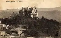
- The castle in neo-gothic style
- La Tude massif
- The church
Several quarries above Montdardier were formerly important sources of lithographic limestone. Stone from these quarries, marketed as Vigan stone, earned an honorable mention in the Great Exhibition of 1851.[4]
References
- "Répertoire national des élus: les maires" (in French). data.gouv.fr, Plateforme ouverte des données publiques françaises. 13 September 2022.
- "Populations légales 2020". The National Institute of Statistics and Economic Studies. 29 December 2022.
- "Fiche Climatologique Statistiques 1991-2020 et records" (PDF) (in French). Météo-France. Retrieved 3 September 2022.
- Class I, Report on Mining, Quarrying, Metallurgical Operations, and Mineral Products, Reports by the Juries on the Subjects in the Thirty Classes Into Which the Exhibition was Divided, Exhibition of the Works of Industry of All Nations, 1851, Clowes, London, 1852; page 28.