Souvignargues
Souvignargues (French pronunciation: [suviɲaʁɡ]; Occitan: Sauvinhargues) is a commune in the Gard department in southern France.
Souvignargues | |
|---|---|
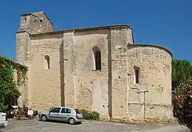 Church of St. Stephen | |
.svg.png.webp) Coat of arms | |
Location of Souvignargues | |
 Souvignargues  Souvignargues | |
| Coordinates: 43°48′53″N 4°07′23″E | |
| Country | France |
| Region | Occitania |
| Department | Gard |
| Arrondissement | Nîmes |
| Canton | Calvisson |
| Intercommunality | Pays de Sommières |
| Government | |
| • Mayor (2020–2026) | Catherine Lecerf[1] |
| Area 1 | 11.09 km2 (4.28 sq mi) |
| Population | 883 |
| • Density | 80/km2 (210/sq mi) |
| Time zone | UTC+01:00 (CET) |
| • Summer (DST) | UTC+02:00 (CEST) |
| INSEE/Postal code | 30324 /30250 |
| Elevation | 42–173 m (138–568 ft) (avg. 100 m or 330 ft) |
| 1 French Land Register data, which excludes lakes, ponds, glaciers > 1 km2 (0.386 sq mi or 247 acres) and river estuaries. | |
Population
| Year | Pop. | ±% |
|---|---|---|
| 1962 | 405 | — |
| 1968 | 406 | +0.2% |
| 1975 | 370 | −8.9% |
| 1982 | 460 | +24.3% |
| 1990 | 545 | +18.5% |
| 1999 | 589 | +8.1% |
| 2008 | 717 | +21.7% |
Sights
- Remains of the feudal castle (13th-14th centuries)
- Church of St. Stephen (Saint-Étienne d'Escattes), at Escattes, dating to the 12th century.
- Ruined Romanesque church of St. Andrew (12th century)
- Grotto of Bézal, inhabited from the mid-Palaeolithic Age
See also
References
- "Répertoire national des élus: les maires" (in French). data.gouv.fr, Plateforme ouverte des données publiques françaises. 13 September 2022.
- "Populations légales 2020". The National Institute of Statistics and Economic Studies. 29 December 2022.
Wikimedia Commons has media related to Souvignargues.
This article is issued from Wikipedia. The text is licensed under Creative Commons - Attribution - Sharealike. Additional terms may apply for the media files.