Sandwip Upazila
Sandwip (Bengali: সন্দ্বীপ) is an upazila of Chattogram District in Chattogram Division, Bangladesh. It encompasses the islands of Sandwip and Urir Char.[2][3]
Sandwip
সন্দ্বীপ | |
|---|---|
 Sandwip Location in Bangladesh | |
| Coordinates: 22°29′N 91°26.5′E | |
| Country | Bangladesh |
| Division | Chittagong Division |
| District | Chittagong District |
| Capital | Sandwip Municipality |
| Jatiya Sangsad constituency | Chittagong-3 |
| Upazila | 1984 |
| Government | |
| • MP | Mahfuzur Rahaman Mita |
| • Chairman | Main Uddin Mission |
| Area | |
| • Total | 762.42 km2 (294.37 sq mi) |
| Population (2016) | |
| • Total | 450,000[1] |
| Time zone | UTC+6 (BST) |
| Website | official website |
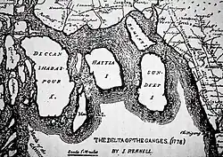
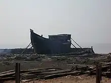
History
.jpg.webp)
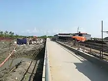
Sandwip Thana's status was upgraded to an upazila (sub-district level) in 1984. The construction works of a Bangladesh Navy fleet headquarters at the Sandwip Channel with ship berthing facilities is also going on as part of the Forces Goal 2030.[4] In 2010, the Government of Bangladesh announced a plan to build a dam in Urir Char to reclaim land as it had suffered greatly from Tropical Storm One and the 1991 Bangladesh cyclone among other natural disasters.[5]
Geography
Sandwip is located at 22.4833°N 91.4417°E. It has a total area of 762.42 km2.[2]
Demographics
According to the 1991 Bangladesh census, Sandwip had a population of 272,179. Males constituted 49.68% of the population, and females 50.32%. The population aged 18 or over was 122,499. Sandwip had an average literacy rate of 35% (7+ years), against the national average of 32.4%.[6]
Sandwip has 45, 389 households.[7]
Administration
Sandwip Upazila is divided into the Sandwip Municipality and 15 union parishads: Amanullah, Azimpur, Bauria, Digghapar, Gachhua, Haramia, Harispur, Kalapania, Magdhara, Maitbhanga, Musapur, Rahmatpur, Santoshpur, Sarikait, and Urirchar. The union parishads are subdivided into 39 mouzas and 34 villages.[8]
Sandwip Municipality is subdivided into 9 wards and 10 mahallas.[8]
List of chairmen and rulers
| Name | Notes |
|---|---|
| Muhammad Rafiqullah Chowdhury | 1985–1990 |
| Mostafa Kamal Pasha | 1990–1995 |
| Mohammad Shajahan | 2009–2023 |
| Main Uddin Mission | 2023–present |
Education
There are 28 secondary schools in Sandwip Upazila. Some these include:
- Kargil Government High School, the oldest school in the Upazila founded in 1879
- Gachua Adarsha High School, established in 1987
- Bauria Golam Khalek Academy
- A. K. Academy, Gachua
- Sandwip Public High School
In total, the Upazila has 149 state primary schools, one junior high school, 4 colleges, 1 girls college, 19 kindergartens and 3 girls high schools. There are 9 dakhil madrasas, 3 alim madrasas, 3 fazil madrasas and four Kamil madrasas. Notable madrasas include the Bashiria Ahmadia Alhaj Abu Bakar Sidiqque Fazil Madrasa, founded in 1902, and the Kashgar Islamia Fazil Madrasa which was founded in 1929. The upazila has a literacy rate of 51.5%.
Facilities
The upazila is home to 10 orphanages, including one governmental orphanage. It also has 295 mosques which serve the majority Sunni Muslim population that inhabit the sub-district. Some notable mosques include the Shahabanu Mosque, Faqir Shah mosque, the Sandwip Town Jame Mosque, Sandwip Town Bazar Mosque and the Abdul Ghani Chowdhury Mosque. There are 32 haat bazaars and two canals. 26 post offices and 10 banks can also be found here.
Notable people
- Chowdhury Abu Torab Khan, leader of Bengal's first anti-British uprising
- Abul Kashem Sandwip, educationist and a founder of Bangladesh Betar
- Abdul Haq
- Abdul Hakim, 17th-century poet
- Abul Fazal Ziaur Rahman, physician and army officer
- AKM Asadul Haq, physician and army officer
- AKM Rafiq Ullah Choudhury, politician and language activist
- Alhaz Mustafizur Rahman, politician
- Belal Muhammad, a founder of Swadhin Bangla Betar Kendra
- Belayet Hossain, Bangladeshi freedom fighter
- Chowdhury Hasan Sarwardy, former lieutenant general of the Bangladesh Army
- Dilal Khan, final independent ruler of Sandwip
- Mahfuzur Rahaman, politician
- M. Obaidul Huq, politician
- Mostafa Kamal Pasha, politician
- Muzaffar Ahmad, politician and journalist
- Mohammed Didarul Alam
- Shamsuddin Qasemi, Islamic scholar and politician
- Lalmohan Sen, revolutionary involved in the Chittagong armoury raid
- Mohit Kamal, psychotherapist
Notes
References
- "Sandwip Upazila (সন্দ্বীপ উপজেলা)". Chittagong. 2011-05-26. Retrieved 2012-11-07.
- Chowdhury, Towhid Hossain (2012). "Sandwip Upazila". In Sirajul Islam; Miah, Sajahan; Khanam, Mahfuza; Ahmed, Sabbir (eds.). Banglapedia: the National Encyclopedia of Bangladesh (Online ed.). Dhaka, Bangladesh: Banglapedia Trust, Asiatic Society of Bangladesh. ISBN 984-32-0576-6. OCLC 52727562. OL 30677644M. Retrieved 27 October 2023.
- "District in Focus: Chittagong".
- "One day BD Navy to become builder from buyer, hopes PM". UNB. 24 December 2017. Archived from the original on 25 December 2017. Retrieved 24 December 2017.
- "Project to recover land of Urir Char". banglanews24.com. 31 August 2010. Archived from the original on 9 February 2019. Retrieved 9 February 2019.
- "Population Census Wing, BBS". Archived from the original on 2005-03-27. Retrieved November 10, 2006.
- "Local Government Engineering Department (LGED)". Archived from the original on 2014-11-03. Retrieved 2017-12-23.
- "District Statistics 2011: Chittagong" (PDF). Bangladesh Bureau of Statistics. Archived from the original (PDF) on 13 November 2014. Retrieved 14 July 2014.
