Sawback Range
The Sawback Range is a mountain range of the Canadian Rockies that stretches from the Bow Valley in Alberta into southeastern Banff National Park.
| Sawback Range | |
|---|---|
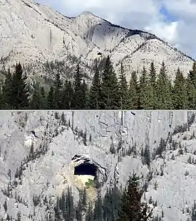 The "Hole in the Wall" is a natural cave on the side of Mount Cory. It is visible from the Trans-Canada Highway. | |
| Highest point | |
| Peak | Mount St. Bride[1] |
| Elevation | 3,315 m (10,876 ft)[2] |
| Coordinates | 51°30′28″N 115°57′19″W[3] |
| Dimensions | |
| Length | 45 km (28 mi) N-S |
| Width | 34 km (21 mi) E-W |
| Area | 622 km2 (240 sq mi)[1] |
| Geography | |
 | |
| Country | Canada |
| Province | Alberta |
| Range coordinates | 51°21′N 115°50′W[4] |
| Parent range | Canadian Rockies |
| Topo map | NTS 82O5 Castle Mountain[4] |
Mountains
This range includes the following mountains and peaks:[5]
| Mountain/Peak | Elevation |
|---|---|
| Mount St. Bride | 3,315 m (10,876 ft) |
| Bonnet Peak | 3,235 m (10,614 ft) |
| Mystic Peak | 2,960 m (9,711 ft) |
| Block Mountain | 2,935 m (9,629 ft) |
| Mount Ishbel | 2,908 m (9,541 ft) |
| Mount Cory | 2,802 m (9,193 ft) |
| Oyster Peak | 2,777 m (9,111 ft) |
| Cockscomb Mountain | 2,776 m (9,108 ft) |
| Mount Louis | 2,682 m (8,799 ft) |
| Mount Fifi | 2,621 m (8,599 ft) |
| Mount Edith | 2,554 m (8,379 ft) |
| The Finger | 2,545 m (8,350 ft) |
See also
References
- "Sawback Range". Peakbagger.com. Retrieved 2012-05-19.
- "Topographic map of Mount St. Bride". opentopomap.org. Retrieved 2023-07-24.
- "Mount St. Bride". Geographical Names Data Base. Natural Resources Canada. Retrieved 2023-07-24.
- "Sawback Range". Geographical Names Data Base. Natural Resources Canada. Retrieved 2022-08-25.
- "Peaks of the Sawback Range". cdnrockiesdatabases.ca. Retrieved 2023-06-07.
This article is issued from Wikipedia. The text is licensed under Creative Commons - Attribution - Sharealike. Additional terms may apply for the media files.