Taguig
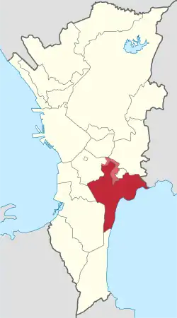
Taguig (Tagalog: [taˈɡiɡ]), officially the City of Taguig (Filipino: Lungsod ng Taguig), is a 1st class highly urbanized city in Metro Manila, Philippines. According to the 2020 census, it has a population of 886,722 people.[3] Located in the northwestern shores of Laguna de Bay, the city is known for Bonifacio Global City, one of the leading financial centers of the Philippines. Originally a fishing village during the Spanish and American colonial periods, it experienced rapid growth when former military reservations were converted by the Bases Conversion and Development Authority (BCDA) into mixed-use planned communities. Taguig became a highly urbanized city with the passage of Republic Act No. 8487 in 2004.
Taguig | |
|---|---|
| City of Taguig | |
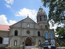
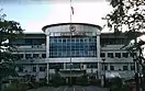
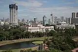
Clockwise from top: Bonifacio Global City, Saint Anne Parish Church, Arca South, Mercado del Lago Lakeshore, Taguig City Hall, Napindan Parola | |
 Seal | |
| Etymology: Taga-giik (rice thresher) | |
| Nickname: Metro Manila's Probinsyudad | |
| Motto: "I Love Taguig" "Think Big. Dream Big. Love Taguig." | |
| Anthem: Martsa ng Taguig ("Taguig March") | |
| |
OpenStreetMap | |
.svg.png.webp) Taguig Location within the Philippines | |
| Coordinates: 14°31′N 121°03′E | |
| Country | Philippines |
| Region | National Capital Region |
| Province | none |
| District | 1st district (shared with Pateros) and 2nd district |
| Established | April 25, 1587 |
| Cityhood | December 8, 2004 |
| Barangays | 28 (de facto) 38 (de jure) (see Barangays) |
| Government | |
| • Type | Sangguniang Panlungsod |
| • Mayor | Ma. Laarni L. Cayetano (Nacionalista) |
| • Vice Mayor | Arvin Ian V. Alit (Nacionalista) |
| • Representatives |
|
| • City Council | Members |
| • Electorate | 449,359 voters (2022) |
| Area | |
| • Total | 45.21 km2 (17.46 sq mi) |
| Elevation | 13 m (43 ft) |
| Highest elevation | 179 m (587 ft) |
| Lowest elevation | −1 m (−3 ft) |
| Population (2020 census)[3] | |
| • Total | 886,722 (de facto) 1,223,595 (de jure) |
| • Rank | 4th |
| • Households | 246,873 |
| Demonym | Taguigeño / Taguigeña |
| Economy | |
| • Income class | 1st city income class |
| • Poverty incidence | 0.76 |
| • Revenue | ₱ 12,755 million (2020) |
| • Assets | ₱ 30,661 million (2020) |
| • Expenditure | ₱ 12,572 million (2020) |
| Utilities | |
| • Electricity | Manila Electric Company (Meralco) |
| • Water | Manila Water |
| • Telecommunications | Globe Telecom Smart Communications Dito Telecommunity |
| • Cable TV | Sky Cable Cignal TV |
| • Internet | Sky Fiber Converge ICT PLDT Fiber |
| Time zone | UTC+8 (PST) |
| ZIP code | 1630–1638 |
| PSGC | |
| IDD : area code | +63 (0)02 |
| Native languages | Filipino (Tagalog) |
| Currency | Philippine peso (₱) |
| Feast date | July 26 |
| Catholic diocese | Roman Catholic Diocese of Pasig |
| Patron saint | Saint Anne |
| Website | www |
_(Taguig_and_Makati)(2018-04-24)_cropped.jpg.webp)


The city is located in the southeastern portion of Metro Manila and bordered by Pasig and Pateros to the north, Makati and Mandaluyong to the northwest, Pasay and Parañaque to the west, Taytay, Rizal to the northeast and Muntinlupa to the south.
Etymology
The original farmer-fishermen of the area, about 800 in number, were good at threshing rice after harvest. Hence, they were referred to as "mga taga-giik" (Tagalog for "rice thresher") and the settlement as "pook ng mga taga-giik" (lit. transl. place of the rice threshers). Spanish friar Fray Alonso de Alvarado, together with conquistador Ruy López de Villalobos who crossed the Pasig River to reach the city's present site in 1571, found "taga-giik" difficult to pronounce. "Tagui-ig" was later shortened to its current form "Taguig".[5]
History
.jpg.webp)
Early history
Before the Spaniards came, Taguig was a part of Namayan and Tondo ruled by Lakandula. There were also accounts that Chinese settlements were once present in the area as revealed by the recent archaeological diggings of various artifacts like cups, plates and other utensils, which bear Chinese characters. This was believed to have originated from China's Ming dynasty.
Spanish colonial era
Taguig was one of the earliest known territories to have been Christianized when the Spaniards succeeded in subjugating mainland Luzon through the Legazpi expedition in 1571. Between the years 1582 and 1583, Taguig was part of the encomienda of Tondo headed by an alcalde mayor, Captain Vergara. It was in 1587 when Taguig was established as a separate "pueblo" (town) of the then province of Tondo (later renamed Manila). Captain Juan Basi was its Kapitan from 1587 to 1588. According to records, Taguig had nine barrios then, namely: Bagumbayan, Bambang, Hagonoy, Palingon, Santa Ana, Tipas, Tuktukan, Ususan, and Wawa. Santa Ana was then the municipal center (poblacion) of Taguig.[6] Records show that Tipas had once petitioned to become an independent town but was denied by the Spanish government.
During that time, Taguig was accessible via the Pasig River, which was connected to two large bodies of water, Manila Bay and Laguna de Bay. The population then was estimated to be 800 tributes. The town produced more than enough rice for consumption but had less sugar cane to mill. The men lived through fishing while women wove cotton cloth and "sawali" from bamboo strips. The people of Taguig were known to have resisted both Spanish and American colonial rule. During that early period of Spanish colonization. Don Juan Basi, "Kapitan" of Taguig from 1587 to 1588, took part in the Tondo Conspiracy, an attempt to overthrow the Spanish government which failed. Basi was exiled for two years as punishment. When the Katipunan was on its early years, many from Taguig became followers and later joined the uprising. The people of Taguig also joined the revolutionary government of General Emilio Aguinaldo on August 6, 1898.
American colonial era
During the American occupation, they struggled against the forces of General Wheaton under the command of General Pio del Pilar. It was recorded that on February 6, 1899, Filipino forces including Taguig "revolutionarios" dislodged an American position in the hills of Taguig, now a portion of Pateros and Fort Bonifacio. They were defeated eventually by the Americans with superiority in the armaments and training. Taguig finally fell to the contingent of the First Washington Volunteer Infantry led by Col. Wholly.
The defeat of the Filipinos after two years of struggle against the American forces subsequently subjected the Philippines to another system of governance. On August 14, 1898, United States occupied the islands and established a military government with General Wesley Meritt as the First Military Governor. He exercised legislative powers until September 1, 1900. At the start of American occupation, Taguig was proclaimed as an independent municipality with the promulgation of General Order No. 4 on March 29, 1900. The town was subsequently incorporated to the newly created province of Rizal when the Philippine Commission promulgated Act No. 137 on June 11, 1901.[7] On October 12, 1903, Taguig, Muntinlupa and Pateros were merged by the virtue of Act. No. 942 with Pateros hosting the seat of the municipal government.[8] The merger did not last long as a month later Muntinlupa was segregated from it and made part of Biñan when Act. No. 1008 was enacted on November 25, 1903.[9] However, it was returned to Taguig on March 22, 1905, with the promulgation Act No. 1308.[10] Eventually, Pateros separated from Taguig by January 1, 1909 and Muntinlupa was granted an independent municipality status on December 17, 1917.[11]
It was also during the American Colonial Period that the United States government acquired a 25.78 km2 (9.95 sq mi) property of Taguig for military purposes. This large piece of land, which had a TCT dated 1902, was turned into a camp that became known as Fort William McKinley, named after the 25th president of the U.S. who was responsible for the American colonization of the Philippines.
Japanese occupation
When the Japanese occupied the Philippines in 1942, Fort McKinley was taken over by the Japanese Imperial Army. They occupied the military camp until the end of World War II in 1945.
Philippine independence
After the Philippines gained its political independence from the United States on July 4, 1946, the US surrendered the Republic of the Philippines all right of possession, jurisdiction, supervision and control over the Philippine territory except the use of the military bases. On May 14, 1949, Fort William McKinley was turned over to the Philippine government by virtue of the US Embassy Note No. 0570. Fort McKinley was made the permanent headquarters of the Philippine Army in 1957 and was subsequently renamed Fort Bonifacio after the Father of the Philippine Revolution against Spain, Andres Bonifacio.
The Martial Law era
When Ferdinand Marcos placed the Philippines under martial law in 1972, Taguig, which contained Fort Bonifacio, became the host of two detention centers full of political prisoners - the Maximum Security Unit where Senators Jose W. Diokno and Benigno Aquino Jr. were detained.[12] and the Ipil Reception Center (sometimes called the Ipil Detention Center).[13] A third facility, the Youth Rehabilitation Center (YRC),[13] was still treated as part of Fort Bonifacio but was later turned into the Makati City Jail.[14] These detention centers became infamous for the numerous human rights abuses of the Marcos dictatorship, including warrantless detention and torture.[13]
Senator Benigno Aquino Jr. and Senator Jose Diokno were Marcos' first martial law prisoners, arrested just before midnight on September 22, 1972, and at 1 AM on September 23, 1972, respectively. They were eventually imprisoned in Fort Bonifacio at the Maximum Security Unit separate from Ipil and YRC. They stayed there until Marcos moved them to an even higher security facility in Fort Magsaysay in Laur, Nueva Ecija on March 12, 1973.
Ipil was the largest prison facility for political prisoners during martial law. Among the prisoners held there were some of the country's leading academics, creative writers, journalists, and historians including Butch Dalisay, Ricky Lee, Bienvenido Lumbera, Jo Ann Maglipon, Ninotchka Rosca, Zeus Salazar, and William Henry Scott. After Fort Bonifacio was privatized, the area in which Ipil was located became the area near S&R Membership Shopping and MC Home Depot, near 32nd Street and 8th Avenue in Bonifacio Global City.[15]
In 1974, the name of the Taguig's political subdivisions was changed from "barrios" to "barangays" following the nationwide implementation of the Integrated Reorganization Plan (IRP) under Presidential Decree No. 557.[16] The IRP increased Taguig's administrative divisions to 18 barangays, namely, Bagong Tanyag, Bagumbayan, Bambang, Calzada, Hagonoy, Ibayo-Tipas, Ligid-Tipas, Lower Bicutan, Maharlika, Napindan, Palingon, Signal Village, Santa Ana, Tuktukan, Upper Bicutan, Ususan, Wawa, and Western Bicutan.
On November 7, 1975, Taguig seceded from the province of Rizal to become part of the newly formed the National Capital Region through Presidential Decree No. 824.[17]
Cityhood
In 1998, a law was enacted, pushing for the cityhood of Taguig.[18] The resulting plebiscite on April 25 showed that the citizens were against the cityhood. A recent petition to the Supreme Court sought a recount of the plebiscite and on February 19, 2004, the Supreme Court ordered the Commission on Elections to conduct a recount. The recount showed that the residents did want the municipality of Taguig to become a city (21,105 'yes' and 19,460 'no'). Subsequently, Taguig became a city on December 8, 2004.[19]
Contemporary history
.jpg.webp)
In 2008, the City Council created 10 new barangays by virtue of City Ordinance Nos. 24–27, 57–61, 67–69, and 78, Series of 2008, carving them out from the initial 18 barangays. Hence, in December 2008, after a successful plebiscite, the numbers of barangays in the city increased from 10 to 28 barangays. The 10 newly created barangays were Central Bicutan, New Lower Bicutan, Fort Bonifacio, Katuparan, North Signal Village, South Signal Village, South Daanghari, North Daanghari, Pinagsama, San Miguel, and Tanyag.[20]
In 2011, during 424th foundation day, Mayor Lani Cayetano takes pride in calling the city a “ProbinSyudad” because it is the only remaining city in Metro Manila which has the amenities of a highly urbanized city, yet has the feel and relaxing atmosphere of a province plus its people exude the values and etiquette of the provincial natives, what with its more than 10 kilometers (6.2 mi) of lakeshore, with farmers, fishermen, old churches, a historic lighthouse, and with people whose virtue of pagtutulungan is still very much alive.[21]
A new, "state-of-the-art" 17-storey Taguig City Hall is currently being built in Barangay Ususan along Cayetano Boulevard. It will replace the current city hall in Barangay Tuktukan that was built in 1959 and was renovated thrice.[22]
Taguig won the territorial dispute with Makati on April 2022, which was ruled with finality a year later on April 2023. The city will gain 10 barangays from Makati, adding an estimated 300,000 people to its population.
Geography
Taguig is located on the northwestern shores of Laguna de Bay, the largest lake in the Philippines. Taguig River, a tributary of the Pasig River, runs through the northern half of the city, while the Napindan River, another tributary of Pasig, forms the natural border between Taguig in Pasig. A relatively small area of the city called Ibayo Napindan is located north of the river, adjoining the disputed territories between Pasig, Taguig and Taytay in Rizal Province. The city has an area of 53.67 square kilometers (20.72 sq mi). Considering its de jure territory that includes the Embo barangays previously from Makati, it borders Mandaluyong to the northwest as well and would have a total area of 59 square kilometers (23 sq mi).
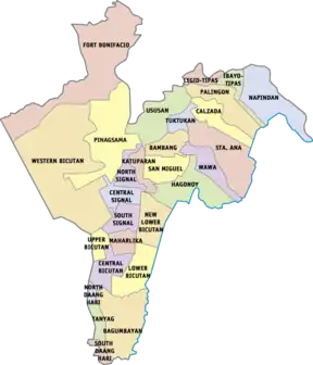
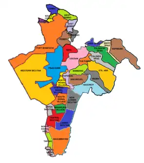
Barangays
The city is politically subdivided into 28 barangays: Bagumbayan, Bambang, Calzada, Central Bicutan, Central Signal Village, Fort Bonifacio, Hagonoy, Ibayo Tipas, Katuparan, Ligid Tipas, Lower Bicutan, Maharlika Village, Napindan, New Lower Bicutan, North Daang Hari, North Signal Village, Palingon Tipas, Pinagsama, San Miguel, Santa Ana, South Daang Hari, South Signal Village, Tanyag, Tuktukan, Ususan, Upper Bicutan, Wawa, and Western Bicutan. An additional 10 barangays are integrated within the city: Cembo, South Cembo, Comembo, East Rembo, West Rembo, Pembo, Rizal, and Pitogo, while the status of Post Proper Northside and Post Proper Southside are still unclear as it overlaps the territory of Fort Bonifacio, all of which formerly forms the Embo areas and eastern Makati.[23][24] However, Taguig is already exercising its jurisdiction with the offering of the city's programs and services over the affected areas. The status of barangays Post Proper Northside and Post Proper Southside from Makati are still unclear as they overlap barangays Fort Bonifacio, Pinagsama, Western Bicutan, and Ususan, respectively. The city is also divided into two legislative districts: the 1st district, which also includes the Municipality of Pateros for representation in the Congress, and 2nd district.
| First District | |||
|---|---|---|---|
| Barangay | Barangay Chairman | Population (2015)[25] | Population (2020)[26] |
| Bagumbayan | Carmi O. Pajatin | 40,685 | 49,319 |
| Bambang | Jaime T. Cruz Jr. | 10,010 | 13,949 |
| Calzada | Marilyn R. Tanyag | 21,747 | 28,660 |
| Hagonoy | Rommel O. Gutierrez | 18,652 | 21,693 |
| Ibayo Tipas | Erwin C. Mendiola | 20,932 | 25,808 |
| Ligid Tipas | Jennifer I. Quilatan | 9,700 | 10,361 |
| Lower Bicutan | Roel O. Pacayra | 56,754 | 60,376 |
| New Lower Bicutan | Gregorio S. Franco Jr. | 49,829 | 55,928 |
| Napindan | Virgilio C. Dela Paz | 19,346 | 24,437 |
| Palingon | Jerome M. Mendiola | 13,705 | 16,119 |
| San Miguel | Vicente G. Espital | 8,590 | 10,528 |
| Santa Ana | Roberto M. Flogen | 18,057 | 22,581 |
| Tuktukan | Suranie G. Ulunday | 10,730 | 11,614 |
| Ususan | Marilyn F. Marcelino | 54,186 | 53,956 |
| Wawa | Phillip E. Buenaflor | 11,177 | 14,350 |
| Second District | |||
| Barangay | Barangay Chairman | Population (2015)[25] | Population (2020)[26] |
| Bagong Tanyag | Cecilia C. Teodoro | 22,711 | 23,719 |
| Central Bicutan | Jennifer F. Alit | 28,705 | 33,851 |
| Central Signal Village | Henry A. Dueñas III | 39,674 | 44,126 |
| Fort Bonifacio | Jorge Daniel S. Bocobo | 11,739 | 11,912 |
| Katuparan | Mario R. Hernandez | 23,062 | 27,228 |
| Maharlika Village | Hareem P. Pautin | 22,944 | 23,470 |
| North Daang Hari | Lorenzo O. Fortuno | 11,771 | 13,673 |
| North Signal Village | Jesus J. Pullente | 32,112 | 34,634 |
| Pinagsama | Nomie S. Veloria | 57,343 | 56,835 |
| South Daang Hari | Velerado D. Hernandez | 19,166 | 22,448 |
| South Signal Village | Michelle Anne M. Odevilas | 39,214 | 43,047 |
| Upper Bicutan | Gemma E. Espejon | 41,216 | 44,592 |
| Western Bicutan | Pedrito B. Bermas | 91,158 | 87,508 |
- Parts of Hagonoy became under the jurisdiction of a new barangay San Miguel
- Lower Bicutan was divided into two, the other one to be known as Barangay New Lower Bicutan
- Signal Village was divided into four barangays, Central Signal Village (originating barangay), Katuparan, North Signal Village, and South Signal Village.
- Bagong Tanyag was divided into three barangays, North Daang Hari, South Daang Hari, and Tanyag proper (originating barangay)
- Parts of Upper Bicutan became under the jurisdiction of a new barangay Central Bicutan
- Western Bicutan was divided into three barangays, Fort Bonifacio, Pinagsama and Western Bicutan (originating barangay)
Territorial disputes
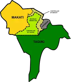
Taguig, Makati and Pateros have fought over the jurisdiction of Fort Bonifacio and nearby places. In 2003, the Pasig Regional Trial Court (RTC) ruled that Fort Bonifacio and Pinagsama Village belongs to Taguig. In 2011, the Pasig RTC also ruled that the Embo barangays (Cembo, South Cembo, East Rembo, West Rembo, Comembo, Pembo), as well as Rizal and Pitogo, are part of Taguig since they were formerly part of the military reservation. Pateros also claims the "embo" barangays, parts of Taguig and Fort Bonifacio, but the municipality's petition were dismissed by the Supreme Court. Meanwhile, the Court of Appeals stopped Taguig from exercising jurisdiction in the said areas in 2013. On 2017, the Court of Appeals upheld its final decision that Fort Bonifacio belongs to Taguig; it was later upheld by the Supreme Court in 2022. The Supreme Court junked the motion for reconsideration that was filed by the Makati city government to override the court's earlier decision, siding with Taguig a year later.
As a result of the ruling, the following Makati barangays are transferred to Taguig:
| Barangay | Alternate name | Etymology | Barangay Chairman | Population (2020)[3] | Area (km2) |
|---|---|---|---|---|---|
| Cembo | Barangay 25 | Central Enlisted Men's Barrio | Romeo B. Millo | 25,049 | 0.22 |
| South Cembo | Barangay 24 | Eva Dian M. Omar | 14,978 | 0.20 | |
| Comembo | Barangay 28 | Combat Enlisted Men's Barrio | Richard V. Peralta | 15,805 | 0.27 |
| East Rembo | Barangay 27 | Riverside Enlisted Men’s Barrio | Thelma P. Ramirez | 26,450 | 0.44 |
| West Rembo | Barangay 26 | Marilou B. Dilla | 29,649 | 0.55 | |
| Pembo | Barangay 29 | Panthers Enlisted Men's Barrio | Jeline M. Olfato | 44,506 | 0.64 |
| Pitogo | Barangay 23 | From pitogo, a local term for a palm plant.[27] | Nemesio C. Alvior | 14,654 | 0.14 |
| Post Proper Northside | Barangay 30 | Both part of Barangay Fort Bonifacio | Richard C. Pasadilla | 57,940 | 0.97 |
| Post Proper Southside | Barangay 31 | Maribel F. Vitales | 63,308 | 1.31 | |
| Rizal | Barangay 33[28] | Named after José Rizal | Mark Bryan C. Beran | 44,536 | 0.59 |
| Total population and area | 336,873 | 5.33 | |||
In addition, Taguig is also involved in a dispute with Pasig and Taytay, Rizal over a large area which covers Ibayo Napindan in Napindan, barangay Pinagbuhatan in Pasig, and Lupang Arendra area in Taytay.
Demographics
|
| |||||||||||||||||||||||||||||||||||||||||||||||||||
| Source: Philippine Statistics Authority[25][29][30][31] | ||||||||||||||||||||||||||||||||||||||||||||||||||||
According to the 2020 census, the population of the city was 886,722 (excluding the Embo barangays that would be transferred to Taguig's de jure jurisdiction in 2023), making it the seventh most populous city in the Philippines, and the fourth most populous city in Luzon.
Should the Embo barangays be included in the population count of Taguig, the population of the city would be 1,223,595 as of the 2020 census. It would make it the fifth most populous city in the Philippines, surpassing Zamboanga City and Cebu City.[32]
Housing
(2018-04-02).jpg.webp)
The city is known for being the location of Fort Bonifacio Tenement (FB Tenement or Tenement), which is known for its central basketball court known as Tenement Court which often serves as a medium for murals and exhibitions.
Climate
The climate of Taguig is characterized by two types of season: dry season from November to April, and wet season from May to October. Rainfall is less evenly distributed.
| Climate data for Taguig City | |||||||||||||
|---|---|---|---|---|---|---|---|---|---|---|---|---|---|
| Month | Jan | Feb | Mar | Apr | May | Jun | Jul | Aug | Sep | Oct | Nov | Dec | Year |
| Average high °C (°F) | 29 (84) |
30 (86) |
32 (90) |
34 (93) |
33 (91) |
31 (88) |
30 (86) |
29 (84) |
29 (84) |
30 (86) |
30 (86) |
29 (84) |
31 (87) |
| Average low °C (°F) | 20 (68) |
20 (68) |
21 (70) |
23 (73) |
24 (75) |
25 (77) |
24 (75) |
25 (77) |
24 (75) |
23 (73) |
22 (72) |
21 (70) |
23 (73) |
| Average precipitation mm (inches) | 7 (0.3) |
7 (0.3) |
9 (0.4) |
21 (0.8) |
101 (4.0) |
152 (6.0) |
188 (7.4) |
170 (6.7) |
159 (6.3) |
115 (4.5) |
47 (1.9) |
29 (1.1) |
1,005 (39.7) |
| Average rainy days | 3.3 | 3.5 | 11.1 | 8.1 | 18.9 | 23.5 | 26.4 | 25.5 | 24.5 | 19.6 | 10.4 | 6.4 | 181.2 |
| Source: Meteoblue (modeled/calculated data, not measured locally)[33] | |||||||||||||
Economy
Taguig's center of trade and commerce are at the Bonifacio Global City, Uptown district, McKinley Hill and McKinley West, and Arca South, which replaced the old Food Terminal, Inc. (FTI) complex. The Philippine Stock Exchange main office and trading floor is located in Taguig.
Despite the rapid urbanization of Taguig, aquaculture and fishing still exist in the city as it is located by Laguna de Bay.[41][42]
Government
.jpg.webp)
Local government
Like other cities in the Philippines, Taguig is governed by a mayor and vice mayor who are elected to three-year terms. The mayor is the executive head and leads the city's departments in executing the city ordinances and improving public services. The city mayor is restricted to three consecutive terms, totaling nine years, although a mayor can be elected again after an interruption of one term. The vice mayor heads a legislative council consisting of 18 members: 8 councilors from the 1st district, 8 councilors from the 2nd district, the president of the Sangguniang Kabataan (Youth Council) Federation as sectoral representative of the youth, and the president of the Association of Barangay Captains (ABC) as barangay sectoral representative. The council is in charge of creating the city's policies in the form of ordinances and resolutions.[43]
Seal of Taguig City
The current seal of Taguig, adopted in 2019, incorporates the colors of the Philippine flag; blue, red, white and yellow. The buildings symbolize the city's transformative growth and continued progress, the heart echoes the "I Love Taguig" motto, the sun represents bright future and warmth, the waves depict water and life, paying homage to the fishing livelihood of Taguigeños, and the rice grains describe the city's etymology (from taga-giik or rice thresher in Tagalog), the 28 grains represent the 28 barangays of Taguig at the time of its adoptation.
City officials
The incumbent mayor is Lani Cayetano. Arvin Alit, a former councilor, is the city's incumbent vice mayor. The current district representatives of the city are Ricardo "Ading" Cruz Jr. for 1st district and Amparo Maria "Pammy" Zamora for 2nd district.
| Designation | First district | Second district |
|---|---|---|
| Representatives | Ricardo Cruz, Jr. (NP) | Maria Amparo Zamora (NP) |
| Mayor | Maria Laarni Cayetano (NP) | |
| Vice Mayor | Arvin Ian Alit (NP) | |
| Councilors | Jaime Labampa (NP) | Nicky Supan (NP) |
| Gigi Valenzuela-De Mesa (NP) | Jaime Garcia (NP) | |
| Rodil Marcelino (NP) | Marisse Balina-Eron (NP) | |
| Fanella Joy Panga-Cruz (NP) | Yasser Pangandaman (NP) | |
| Gamaliel San Pedro (NP) | Jomil Bryan Serna (NP) | |
| Carlito Ogalinola (NP) | Eduardo Prado (NP) | |
| Raul Aquino (NP) | Edgar Baptista (NP) | |
| Totong Mañosca (NP) | Alex Penolio (NP) | |
| ABC President | Jorge Daniel Bocobo (Fort Bonifacio) | |
| SK President | Maryruth Maximo (Bagumbayan) | |
Education
Taguig City[44] is home to several prestigious international schools which provide international education to Metro Manila residents, such as the British School Manila, Everest Academy Manila, International School Manila, and Manila Japanese School, which are all located in the University Parkway of Bonifacio Global City. The Chinese International School Manila, Enderun Colleges, and Korean International School Philippines are in the nearby area of McKinley Hill, while The Beacon School is located along the nearby Chino Roces Avenue.
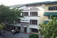
The Taguig City University is the prime university run and managed by the city. Established in 2004 through Ordinance No. 29, Series of 2004 (enacted September 6, 2004, Municipal Government of Taguig. The university main campus is located inside the Taguig City Hall of Justice Compound.[45]
Other schools in Fort Bonifacio are the STI College Global City, Global City Innovative College, Leaders International Christian School of Manila (Christian-based curriculum), Victory Leadership Institute, and MGC-New Life Christian Academy.
Two of the top state universities are also in Taguig—the Polytechnic University of the Philippines, and the Technological University of the Philippines. Both universities are located within the city in Central Bicutan and Western Bicutan.
The University of Santo Tomas in 2015 offered an offsite Masters in Business Administration (MBA) class of its Graduate School at the PCCI Building at McKinley Hill.[46] Also at McKiney Hill, De La Salle University also has a microcampus that houses the Dr. Andrew L. Tan Data Science Institute (ALTDSI) research group and Dr. Andrew L. Tan Data Center and Computing Facility since 2023.[47]
In 2016, the University of the Philippines inaugurated its campus in Bonifacio Global City for its law programs.[48] Following that year in 2017, the De La Salle University opened its Rufino Campus at Bonifacio Global City's University Parkway Drive that is the new home to its College of Law.[49]
Enderun Colleges, an affiliate of Les Roches International School of Hotel Management-Switzerland is an undergraduate college and management school in the Philippines that offers a full range of bachelor's degree and non-degree courses in the fields of international hospitality management and business administration.[50] Likewise, the Meridian International College (MINT), a tertiary educational institution of arts, business and technology are both located in McKinley Hill, Barangay Pinagsama, Taguig City.[51]
Taguig City University, the city's local state university located in Central Bicutan, began operations in November 2006.[52]
The Technical Education and Skills Development Authority (TESDA) was established through the enactment of "Technical Education and Skills Development Act of 1994", which was signed into law by President Fidel V. Ramos. This Act aims to encourage the full participation of and mobilize the industry, labor, local government units, and technical-vocational institutions in the skills development of the country's human resource. The TESDA complex and facilities are located at the East Service Road of the South Luzon Expressway in Taguig.
The Philippine Public Safety College in Fort Bonifacio is an educational institution offering undergraduate and graduate programs for the training, human resource development, and continuing education of police, fire and jail personnel.
Taguig has two Islamic educational institutions located in Maharlika Village—the Maharlika Bandara-Inged Integrated School and the Maharlika Village Islamic Madrasa.
Other notable schools in Taguig include the city's Science High Schools Taguig Science High School in Barangay San Miguel, Senator Renato "Compañero" Cayetano Memorial Science and Technology High School in Ususan, Taguig National High School, a state-owned secondary institution in New Lower Bicutan, Western Bicutan National High School, a public national high school situated in both Bareangays Western Bicutan and Pinagsama, the Catholic Church-owned Colegio de Santa Ana (formerly Santa Ana Parochial School), The Fisher Valley College, a Christian school in Hagonoy and Pinagsama and Saint Francis of Assisi College System, a Catholic school in Bagumbayan.
In addition, the University of Makati, which is owned and operated by the City Government of Makati and is situated in Barangay West Rembo, is in the territory of Taguig by virtue of the Supreme Court decision transferring the former Embo barangays of Makati to Taguig. 13 other public schools of Makati are also located in such area.[53]
Taguig is set to become the new "university city" of Metro Manila as new campuses of University of the Philippines Professional Schools and De La Salle University are located in Bonifacio Global City.[54][55]
Notable personalities
 Pia Cayetano, Senator
.jpg.webp) Alan Peter Cayetano, Senator
Alan Peter Cayetano, Senator Bea Alonzo, actress
- Dante Tiñga, former Associate Justice of the Supreme Court
- Daryl Borja Ruiz, also known as Skusta Clee, ExB rapper, singer-songwriter
- Rene Cayetano, former Senator
- Felix Y. Manalo, Iglesia Ni Cristo Preacher
- Lino Cayetano, TV/movie director, former Congressman, Mayor
- Jamalul Kiram III, claimant to throne of Sultanate of Sulu
- Ervic Vijandre, actor
- Precious Lara Quigaman, actress and Miss International 2005 titleholder
- Lance Lucido, Filipino child actor
- Rene Facunla Humpshire a.k.a. Ate Glow, Filipino Actor/Commediane/Impersonator
- Lucita Soriano, actress
- Laureana Franco, humanitarian, catechist and sainthood candidate
- Groups
- Taguig Renegade Drum and Lyre Corps, 3-time National Drum and Lyre champion
International relations
Diplomatic missions
Countries that have set up permanent missions or offices in the city include:
Notes
References
- City of Taguig | (DILG)
- "2015 Census of Population, Report No. 3 – Population, Land Area, and Population Density" (PDF). Philippine Statistics Authority. Quezon City, Philippines. August 2016. ISSN 0117-1453. Archived (PDF) from the original on May 25, 2021. Retrieved July 16, 2021.
- Census of Population (2020). "National Capital Region (NCR)". Total Population by Province, City, Municipality and Barangay. Philippine Statistics Authority. Retrieved July 8, 2021.
- Error: Unable to display the reference properly. See the documentation for details.
- "History". Official Website of The City of Taguig. Retrieved April 18, 2016.
- "Taguig's Santa Ana and the "probinsyudad" feels". The Urban Roamer. February 5, 2021. Retrieved June 16, 2023.
- Act No. 137 (June 11, 1901). An Act Extending the Provisions of the Provincial Government Act to the Province of Rizal. Retrieved June 16, 2023.
- Act No. 942 (October 12, 1903). An Act Reducing the Thirty-Two Municipalities of the Province of Rizal to Fifteen. Retrieved June 16, 2023.
- Act No. 1008 (November 25, 1903). An Act Amending Act Numbered Nine hundred and thirty-nine, entitled "An Act reducing the thirty municipalities of the Province of La Laguna to nineteen," and Act Numbered Nine hundred and forty-two, entitled "An Act reducing the thirty - two municipalities of the Province of Rizal to fifteen," and providing that the boundary line between the Provinces of La Laguna and Rizal be changed so as to include in La Laguna the municipality of Muntinlupa now a part of Rizal. Retrieved June 16, 2023.
- Act No. 1308 (March 22, 1905). An Act providing for the return of the former municipality of Muntinlupa from the Province of La Laguna to the Province of Rizal, repealing paragraph (e) of section one and sections two and three of Act Numbered One thousand and eight, and changing the name of the municipality of Pateros, of the Province of Rizal, to Taguig. Retrieved June 16, 2023.
- "History". City Government of Muntinlupa. Retrieved June 16, 2023.
- de Villa, Kathleen (September 22, 2018). "Remnants of a dark era". Retrieved October 21, 2022.
- "Detention CampManila Today | Manila Today". www.manilatoday.net. Archived from the original on October 20, 2014. Retrieved April 19, 2022.
- Hilario, Ernesto M. "Martial Law Stories: Never Again to Martial Law". Positively Filipino. Retrieved October 22, 2022.
- Velarde, Emmie G. (September 22, 2014). "Screenwriter Ricky Lee lived 3 lives in detention". INQUIRER.net. Retrieved October 22, 2022.
- Presidential Decree No. 557 (September 21, 1974). Declaring all barrios in the Philippines as barangays, and for other purposes. Retrieved June 16, 2023.
- Presidential Decree No. 824 (November 7, 1975). Creating the Metropolitan Manila and the Metropolitan Manila Commission and for Other Purposes. Retrieved June 16, 2023.
- Republic Act No. 8487 (February 11, 1998). An Act Converting the Municipality of Taguig, Metro Manila, into a Highly Urbanized City to be Known as the City of Taguig, and for Other Purposes (PDF). Retrieved October 8, 2017.
- Clapano, Jose Rodel (January 26, 2006). "SC upholds Taguig cityhood". The Philippine Star. Retrieved June 16, 2023.
- Villanueva, Rhodina (May 10, 2009). "Taguig names heads of city's 10 new barangays". The Philippine Star. Retrieved April 18, 2016.
- "NCR's 'ProbinSyudad' holds 424th Anniversary". Philstar.com. April 24, 2011. Retrieved June 16, 2023.
- Cabalza, Dexter (July 26, 2019). "New 17-story Taguig city hall to be completed in 2021". Inquirer.net. Retrieved August 26, 2023.
- "SC declares final 2021 decision on Taguig City-Makati City land dispute". Manila Bulletin. Retrieved April 3, 2023.
- "Taguig LGU lauds SC decision over Fort Bonifacio ownership". Manila Bulletin. Retrieved April 3, 2023.
- Census of Population (2015). "National Capital Region (NCR)". Total Population by Province, City, Municipality and Barangay. Philippine Statistics Authority. Retrieved June 20, 2016.
- "2020 Census of Population and Housing (2020 CPH) Population Counts Declared Official by the President | Philippine Statistics Authority". psa.gov.ph. Retrieved July 12, 2021.
- "Pitogo - Introduction". Makati Web Portal. Retrieved April 30, 2022.
- Republic Act No. 10961 (July 24, 2017). An Act Creating a Barangay to Be Known as Barangay Rizal in the City of Makati (PDF). Senate of the Philippines Legislative Digital Resources. Retrieved September 26, 2022.
- Census of Population and Housing (2010). "National Capital Region (NCR)" (PDF). Total Population by Province, City, Municipality and Barangay. National Statistics Office. Retrieved June 29, 2016.
- Censuses of Population (1903–2007). "National Capital Region (NCR)". Table 1. Population Enumerated in Various Censuses by Province/Highly Urbanized City: 1903 to 2007. National Statistics Office.
- "Province of Metro Manila, 4th (Not a Province)". Municipality Population Data. Local Water Utilities Administration Research Division. Retrieved December 17, 2016.
- Census of Population (2020). Table B - Population and Annual Growth Rates by Province, City, and Municipality - By Region. Philippine Statistics Authority. Retrieved July 8, 2021.
- "Taguig: Average Temperatures and Rainfall". Meteoblue. Retrieved May 13, 2020.
- "Poverty incidence (PI):". Philippine Statistics Authority. Retrieved December 28, 2020.
- "Estimation of Local Poverty in the Philippines" (PDF). Philippine Statistics Authority. November 29, 2005.
- "2003 City and Municipal Level Poverty Estimates" (PDF). Philippine Statistics Authority. March 23, 2009.
- "City and Municipal Level Poverty Estimates; 2006 and 2009" (PDF). Philippine Statistics Authority. August 3, 2012.
- "2012 Municipal and City Level Poverty Estimates" (PDF). Philippine Statistics Authority. May 31, 2016.
- "Municipal and City Level Small Area Poverty Estimates; 2009, 2012 and 2015". Philippine Statistics Authority. July 10, 2019.
- Error: Unable to display the reference properly. See the documentation for details.
- Cinco, Maricar (July 25, 2021). "Program for Laguna de Bay good, but fishers feel forgotten". INQUIRER.net. Retrieved October 14, 2023.
- Cudis, Christine (July 21, 2021). "Agri-industrial hub to rise in Taguig City". Philippine News Agency. Retrieved October 14, 2023.
- Republic Act No. 7160 (October 10, 1991). An Act Providing for a Local Government Code of 1991. The LawPhil Project. Retrieved April 18, 2016.
- Taguig city book
- https://www.facebook.com/officialtcu/
- "Now accepting applicants for MBA extension class at the Bonifacio Global City (BGC) | UST - Graduate School".
- "Megaworld and DLSU Jointly Inaugurate DLSU McKinley Microcampus, Marking a Milestone in Research and Education". Dr. Andrew L. Tan Data Science Institute. May 1, 2023. Retrieved October 14, 2023.
- "New UP campus in BGC to open this 2016". March 2, 2016.
- Yee, Jovic. "DLSU inaugurates law campus in Bonifacio Global City". Philippine Daily Inquirer.
- "Management School in the Philippines | Business Administration, Hospitality Management".
- "Our Story". MINT College.
- Taguig University will have own campus in 2009 Archived February 22, 2008, at the Wayback Machine, newsinfo.inquirer.net; accessed August 10, 2015.
- Cruz, James Patrick (August 23, 2023). "Makati to lease some EMBO schools to Taguig". Rappler. Retrieved August 25, 2023.
- Frialde, Mike (July 21, 2015). "Taguig to become 'university city' with new UP, DLSU campuses". The Philippine Star. Archived from the original on January 14, 2016. Retrieved February 1, 2016.
- "Taguig becoming a 'University City'". Official Website of The City of Taguig. Retrieved February 1, 2016.
- "Council approves sisterhood, twinning with Taguig". SunStar. May 11, 2012. Archived from the original on June 16, 2013.
- "Himamaylan City eyes sisterhood deal with Taguig City". SunStar Bacolod. November 13, 2022.
- "Iloilo honors sister cities". Manila Bulletin. August 26, 2018. Archived from the original on July 25, 2019. Retrieved July 25, 2019.
- "RESOLUTION EXPRESSING INTENTION FOR SISTERHOOD AND TWINNING WITH TAGUIG CITY". Tabaco City.com. March 21, 2011. Archived from the original on October 29, 2013. Retrieved May 14, 2013.
- "A RESOLUTION EXTENDING AN INVITATION TO THE CITY OF TAGUIG TO BECOME A SISTER CITY OF VIGAN, ILOCOS SUR" (PDF). City of Vigan. February 18, 2008. Archived from the original (PDF) on April 19, 2021.
- "Taguig Mayor Lani Cayetano Forges Links with Mayor Stephen Bali of Blacktown City in Australia". DFA.gov.ph. March 28, 2018. Archived from the original on April 21, 2021. Retrieved July 25, 2019.
- "Taguig forges friendship with Korea's Goyang City". MetroManilaPolitics.gov.ph. July 25, 2023.
External links
- Official Website of Taguig City
- Philippine Standard Geographic Code
- Think Big Taguig - Official Lifestyle Website Archived November 24, 2020, at the Wayback Machine
- Official Facebook page of City of Taguig
- Taguig City General Information
 Geographic data related to Taguig at OpenStreetMap
Places adjacent to Taguig | |
|---|---|
(2017-08-13).jpg.webp)
.jpg.webp)
(2018-05-27).jpg.webp)