Červená Lhota
Červená Lhota is a municipality and village in Třebíč District in the Vysočina Region of the Czech Republic. It has about 200 inhabitants.
Červená Lhota | |
|---|---|
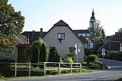 View towards the Church of Saint Lawrence | |
 Flag  Coat of arms | |
 Červená Lhota Location in the Czech Republic | |
| Coordinates: 49°17′4″N 15°48′22″E | |
| Country | |
| Region | Vysočina |
| District | Třebíč |
| First mentioned | 1400 |
| Area | |
| • Total | 7.40 km2 (2.86 sq mi) |
| Elevation | 498 m (1,634 ft) |
| Population (2023-01-01)[1] | |
| • Total | 189 |
| • Density | 26/km2 (66/sq mi) |
| Time zone | UTC+1 (CET) |
| • Summer (DST) | UTC+2 (CEST) |
| Postal code | 675 07 |
| Website | www |
Červená Lhota lies approximately 10 kilometres (6 mi) north-west of Třebíč, 20 km (12 mi) south-east of Jihlava, and 134 km (83 mi) south-east of Prague.
This article is issued from Wikipedia. The text is licensed under Creative Commons - Attribution - Sharealike. Additional terms may apply for the media files.