Lesní Jakubov
Lesní Jakubov is a municipality and village in Třebíč District in the Vysočina Region of the Czech Republic. It has about 100 inhabitants.
Lesní Jakubov | |
|---|---|
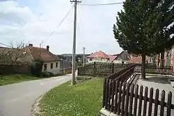 Centre of Lesní Jakubov | |
 Flag  Coat of arms | |
 Lesní Jakubov Location in the Czech Republic | |
| Coordinates: 49°12′21″N 16°14′36″E | |
| Country | |
| Region | Vysočina |
| District | Třebíč |
| First mentioned | 1356 |
| Area | |
| • Total | 3.19 km2 (1.23 sq mi) |
| Elevation | 444 m (1,457 ft) |
| Population (2023-01-01)[1] | |
| • Total | 109 |
| • Density | 34/km2 (88/sq mi) |
| Time zone | UTC+1 (CET) |
| • Summer (DST) | UTC+2 (CEST) |
| Postal code | 675 73 |
| Website | www |
Lesní Jakubov lies approximately 27 kilometres (17 mi) east of Třebíč, 53 km (33 mi) south-east of Jihlava, and 164 km (102 mi) south-east of Prague.
This article is issued from Wikipedia. The text is licensed under Creative Commons - Attribution - Sharealike. Additional terms may apply for the media files.