Opatov (Třebíč District)
Opatov is a market town in Třebíč District in the Vysočina Region of the Czech Republic. It has about 800 inhabitants.
Opatov | |
|---|---|
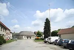 Centre of Opatov | |
 Flag  Coat of arms | |
 Opatov Location in the Czech Republic | |
| Coordinates: 49°13′28″N 15°39′42″E | |
| Country | |
| Region | Vysočina |
| District | Třebíč |
| First mentioned | 1068 |
| Area | |
| • Total | 19.03 km2 (7.35 sq mi) |
| Elevation | 582 m (1,909 ft) |
| Population (2023-01-01)[1] | |
| • Total | 773 |
| • Density | 41/km2 (110/sq mi) |
| Time zone | UTC+1 (CET) |
| • Summer (DST) | UTC+2 (CEST) |
| Postal code | 675 28 |
| Website | www |
Geography
Opatov is located about 15 kilometres (9 mi) west of Třebíč and 19 km (12 mi) south of Jihlava. It lies in the Křižanov Highlands. The highest point is the Brtník hill at 681 m (2,234 ft) above sea level. The Brtnice River flows through the market town. There are several ponds in the municipal territory.
History
The first written mention of Opatov is from 1086. In 1487, it was bought by the Waldstein family. In 1540, the village was promoted to a market town. From 1623, Opatov was a property of the Collalto family. In 1662 or 1696 (according to various chroniclers), a large fire destroyed most of the market town.[2]
Sights
The main landmark of Opatov is the Church of Saint Bartholomew. It was built in the Neoclassical style in 1841–1844.[3] Opposite the church stands a valuable Baroque rectory.[4]
References
- "Population of Municipalities – 1 January 2023". Czech Statistical Office. 2023-05-23.
- "Významná data z historie" (in Czech). Městys Opatov. Retrieved 2023-09-04.
- "Kostel sv. Bartoloměje" (in Czech). National Heritage Institute. Retrieved 2023-09-04.
- "Fara" (in Czech). National Heritage Institute. Retrieved 2023-09-04.