Výčapy
Výčapy is a municipality and village in Třebíč District in the Vysočina Region of the Czech Republic. It has about 900 inhabitants.
Výčapy | |
|---|---|
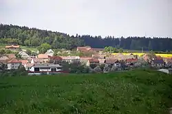 General view | |
 Flag  Coat of arms | |
 Výčapy Location in the Czech Republic | |
| Coordinates: 49°8′37″N 15°52′39″E | |
| Country | |
| Region | Vysočina |
| District | Třebíč |
| First mentioned | 1104 |
| Area | |
| • Total | 13.36 km2 (5.16 sq mi) |
| Elevation | 478 m (1,568 ft) |
| Population (2023-01-01)[1] | |
| • Total | 867 |
| • Density | 65/km2 (170/sq mi) |
| Time zone | UTC+1 (CET) |
| • Summer (DST) | UTC+2 (CEST) |
| Postal code | 674 01 |
| Website | www |
Výčapy lies approximately 9 kilometres (6 mi) south of Třebíč, 35 km (22 mi) south-east of Jihlava, and 149 km (93 mi) south-east of Prague.
Administrative parts
The village of Štěpánovice is an administrative part of Výčapy.
This article is issued from Wikipedia. The text is licensed under Creative Commons - Attribution - Sharealike. Additional terms may apply for the media files.