Armix
Armix is a commune in the Ain department in the Auvergne-Rhône-Alpes region of eastern France.
Armix | |
|---|---|
Commune | |
 | |
Location of Armix | |
 Armix  Armix | |
| Coordinates: 45°51′00″N 5°35′11″E | |
| Country | France |
| Region | Auvergne-Rhône-Alpes |
| Department | Ain |
| Arrondissement | Belley |
| Canton | Plateau d'Hauteville |
| Intercommunality | Bugey Sud |
| Government | |
| • Mayor (2020–2026) | Véronique Vuilloud[1] |
| Area 1 | 6.82 km2 (2.63 sq mi) |
| Population | 26 |
| • Density | 3.8/km2 (9.9/sq mi) |
| Time zone | UTC+01:00 (CET) |
| • Summer (DST) | UTC+02:00 (CEST) |
| INSEE/Postal code | 01019 /01510 |
| Elevation | 420–1,064 m (1,378–3,491 ft) (avg. 720 m or 2,360 ft) |
| 1 French Land Register data, which excludes lakes, ponds, glaciers > 1 km2 (0.386 sq mi or 247 acres) and river estuaries. | |
Geography
Armix is located some 30 km south-east of Amberieu-en-Bugey and 40 km north-west of Aix-les-Bains. It can be accessed by road D103 from Rossillon in the south passing through the village and continuing north to Premillieu. There are few small mountain roads in the commune which is entirely mountainous and mostly forested.
The Ruisseau Pointay rises near the village and flows south joining the Ruisseau de la Chana which forms part of the southern border and continues south-west to join the Furans river.[3]
Neighbouring communes and villages[3] | ||||||||||||||||
|---|---|---|---|---|---|---|---|---|---|---|---|---|---|---|---|---|
| ||||||||||||||||
Administration
List of mayors of Armix[4]
| From | To | Name |
|---|---|---|
| 1995 | 2001 | Georges Galley |
| 2001 | 2008 | Michel Miguet |
| 2008 | 2014 | Gérard Billon-Grand |
| 2014 | Present | Véronique Vuilloud |
Economy
The Economy of the commune of Armix is mostly Agriculture. The commune of Armix is located in the Rhone-Alpes, region in the department of Ain. The economy of the Rhone-Alpes region is based on raw materials, agriculture and energy.
Population
| Year | Pop. | ±% p.a. |
|---|---|---|
| 1968 | 48 | — |
| 1975 | 33 | −5.21% |
| 1982 | 28 | −2.32% |
| 1990 | 14 | −8.30% |
| 1999 | 15 | +0.77% |
| 2007 | 25 | +6.59% |
| 2012 | 20 | −4.36% |
| 2017 | 28 | +6.96% |
| Source: INSEE[5] | ||
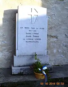
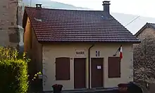
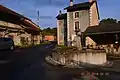
Armix Photo Gallery
 Armix Town Square
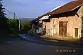 A street in Armix
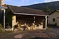 Armix Lavoir (Public Laundry)
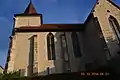 Armix Church
See also
References
- "Répertoire national des élus: les maires" (in French). data.gouv.fr, Plateforme ouverte des données publiques françaises. 13 September 2022.
- "Populations légales 2020". The National Institute of Statistics and Economic Studies. 29 December 2022.
- Google Maps
- List of Mayors of France (in French)
- Population en historique depuis 1968, INSEE