Champfromier
Champfromier (French pronunciation: [ʃɑ̃fʁɔmje]) is a commune in the Ain department in eastern France.[3]
Champfromier | |
|---|---|
Commune | |
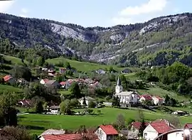 | |
Location of Champfromier | |
 Champfromier  Champfromier | |
| Coordinates: 46°12′00″N 5°49′00″E | |
| Country | France |
| Region | Auvergne-Rhône-Alpes |
| Department | Ain |
| Arrondissement | Nantua |
| Canton | Valserhône |
| Intercommunality | Pays Bellegardien |
| Government | |
| • Mayor (2020–2026) | Jacques Vialon[1] |
| Area 1 | 32.40 km2 (12.51 sq mi) |
| Population | 726 |
| • Density | 22/km2 (58/sq mi) |
| Time zone | UTC+01:00 (CET) |
| • Summer (DST) | UTC+02:00 (CEST) |
| INSEE/Postal code | 01081 /01410 |
| Elevation | 480–1,540 m (1,570–5,050 ft) (avg. 646 m or 2,119 ft) |
| 1 French Land Register data, which excludes lakes, ponds, glaciers > 1 km2 (0.386 sq mi or 247 acres) and river estuaries. | |
Population
| Year | Pop. | ±% p.a. |
|---|---|---|
| 1968 | 428 | — |
| 1975 | 326 | −3.81% |
| 1982 | 332 | +0.26% |
| 1990 | 440 | +3.58% |
| 1999 | 593 | +3.37% |
| 2007 | 630 | +0.76% |
| 2012 | 696 | +2.01% |
| 2017 | 729 | +0.93% |
| Source: INSEE[4] | ||
See also
References
- "Répertoire national des élus: les maires". data.gouv.fr, Plateforme ouverte des données publiques françaises (in French). 9 August 2021.
- "Populations légales 2020". The National Institute of Statistics and Economic Studies. 29 December 2022.
- (Ain), Champfromier 2000 (2001). Champfromier: les moissons de la mémoire (in French). Musnier Gilbert (Editions). ISBN 9782910267414.
- Population en historique depuis 1968, INSEE
Wikimedia Commons has media related to Champfromier.
This article is issued from Wikipedia. The text is licensed under Creative Commons - Attribution - Sharealike. Additional terms may apply for the media files.