Artavan
Artavan
Արտավան | |
|---|---|
 | |
 Artavan 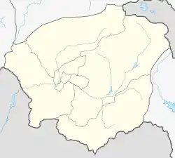 Artavan | |
| Coordinates: 39°39′27″N 45°37′00″E | |
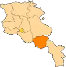
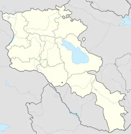
| Country | Armenia |
| Province | Vayots Dzor |
| Municipality | Vayk |
| Population | |
| • Total | 321 |
| Time zone | UTC+4 (AMT) |
| Artavan at GEOnet Names Server | |
Artavan (Armenian: Արտավան) is a village in the Vayk Municipality of the Vayots Dzor Province of Armenia.[2] Situated in the area where the Artavan river originates, a left tributary to the Arpa river, the village is situated at an elevation of 1880 m above sea level, approximately 32 km southeast of the Province center.
Etymology
Previously known as Agkhach, the village was part of the Sharur-Daralayaz uezd of the Erivan Governorate. According to Ghevont Alishan, it was historically known as Aghberakhach village, belonging to the Chahuk gavar of the Syunik historical province of Greater Armenia.[3]
Population
Ancestors of the residents migrated from Khoy and Salmast between 1828 and 1830.
The population dynamics of Artavan over the years:[4]
| Year | 1897 | 1926 | 1939 | 1959 | 1979 | 2001 | 2004 | 2011 |
|---|---|---|---|---|---|---|---|---|
| Population | 433 | 380 | 460 | 588 | 336 | 379 | 395 | 321[1] |
Occupation
The population is engaged in animal husbandry, tobacco, and grain cultivation, fruit growing, and beekeeping.
Historical and cultural sites
The village boasts well-preserved churches and chapels dating back to the 17th to 19th centuries, along with chapels from the 13th to 14th centuries and the 19th century. Besides, there are khachkars (cross-stones) that range from the 11th to 15th centuries and the 17th to 18th centuries.
Gallery


References
- Statistical Committee of Armenia. "The results of the 2011 Population Census of Armenia" (PDF).
- "RA Vayots Dzor Marz" (PDF). Marzes of the Republic of Armenia in Figures. 2009. pp. 264–270. Retrieved 27 June 2023.
- H. Barseghyan, S. Melik-Bakhshyan, E. Aghayan (2001). Dictionary of the toponymy of Armenia and adjacent territories, vol. 1. Yerevan: YSU Publishing House. p. 992.
{{cite book}}: CS1 maint: multiple names: authors list (link) - "Centre of Geodesy and Cartography" SNCO under Cadastre Committee of the Republic of Armenia (2008). Dictionary of settlements of the Republic of Armenia (PDF). Yerevan. p. 38. Archived from the original (PDF) on 2020-02-09. Retrieved 2023-08-04.
{{cite book}}: CS1 maint: location missing publisher (link)
External links
- Report of the results of the 2001 Armenian Census, Statistical Committee of Armenia
- Kiesling, Brady (2005), Rediscovering Armenia: Guide, Yerevan, Armenia: Matit Graphic Design Studio
- Kiesling, Brady (June 2000). Rediscovering Armenia: An Archaeological/Touristic Gazetteer and Map Set for the Historical Monuments of Armenia (PDF). Archived (PDF) from the original on 6 November 2021.