Bardzruni
Bardzruni
Բարձրունի | |
|---|---|
 | |
 Bardzruni 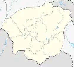 Bardzruni | |
| Coordinates: 39°31′15″N 45°28′56″E | |
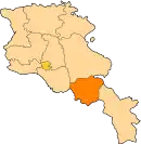
| Country | Armenia |
| Province | Vayots Dzor |
| Municipality | Vayk |
| Population | |
| • Total | 361 |
| Time zone | UTC+4 (AMT) |
| Bardzruni at GEOnet Names Server | |
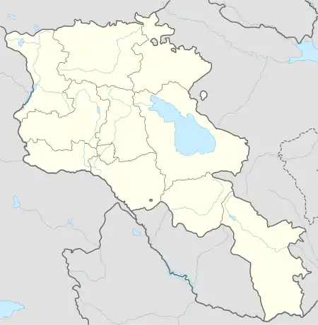
Bardzruni (Armenian: Բարձրունի) is a village in the Vayk Municipality of the Vayots Dzor Province of Armenia.[2] Situated on the southern slopes of the Vayots Dzor mountains in Armenia, the village is positioned 41 km to the southeast of the Province Center and 28 km away from the city of Vayk. It is also a border settlement located at an elevation ranging from 1950 to 2050 meters above sea level. The village is 220 km away from Yerevan, the capital city of Armenia.
Etymology
The village was previously known as Sultanbek.
History
Established at the beginning of the 19th century, the village underwent resettlement in 1928 by Armenian immigrants from Khoy and Salmast gavars. Previously known as "Sultan Bek," the village underwent a renaming process in 1935.[3] However, the village is older than assumed. This is evidenced by the khachkars (cross-stones), dated to the 7th century, found in the area called "Hin Gyugh" (Old Village), as well as half-destroyed structures with ornamental and hewn stones.
Climate
The climate is cold in winter and cool in summer. The yearly precipitation ranges between 350 and 400 mm. The climate is favorable for cultivating horticulture, cereals, and fodder crops.
Population
According to the RA 2011 census results, Bardzruni had a recorded permanent population of 361 individuals, with a current population of 335.[1] The residents are primarily Armenians,[4] whose ancestors predominantly migrated from Salmast in 1829.
The population dynamics of Bardzruni over the years:[5]
| Year | 1831 | 1873 | 1897 | 1926 | 1939 | 1959 | 1970 | 1979 | 1989 | 2001 | 2011 |
|---|---|---|---|---|---|---|---|---|---|---|---|
| Population | 126[4] | 663[4] | 809 | 623 | 1050 | 557 | 556 | 495 | 405[6] | 437 | 361[1] |
Occupation
Agriculture serves as the primary sphere of livelihood in the village. The local population is involved in arable farming, horticulture, animal husbandry, and beekeeping. Reserve lands are not used because they are on the border.
Historical and cultural sites
The village preserves churches dating back to 1884 and the 13th-14th centuries, along with 19th-century chapels and khachkars (cross-stones) from the 13th-17th centuries. Besides, St. George church is located 1 km southeast.
Gallery
%252C_view_from_Bardzruni_-_panoramio.jpg.webp) View of Mount Sangyar from Bardzruni
View of Mount Sangyar from Bardzruni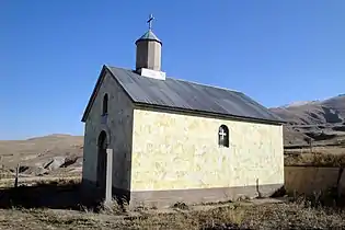 Chapel in Bardzruni
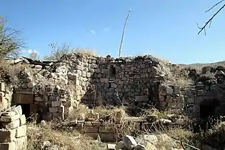 14th-15th century church
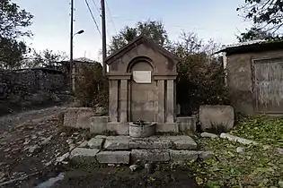 Memorial spring to the fallen in WWII
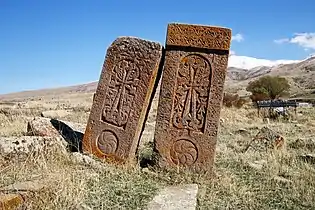 16th century Khachkars
References
- Statistical Committee of Armenia. "The results of the 2011 Population Census of Armenia" (PDF).
- "RA Vayots Dzor Marz" (PDF). Marzes of the Republic of Armenia in Figures. 2009. pp. 264–270. Retrieved 27 June 2023.
- H. Barseghyan, S. Melik-Bakhshyan, E. Aghayan (1986). Dictionary of the toponymy of Armenia and adjacent territories, vol. 5. Yerevan: YSU Publishing House. p. 992.
{{cite book}}: CS1 maint: multiple names: authors list (link) - Zaven Korkotyan (1932). The population of Soviet Armenia in the last century (1831-1931) (PDF). Yerevan: Publication of the Melkonian Fund.
- "Centre of Geodesy and Cartography" SNCO under Cadastre Committee of the Republic of Armenia (2008). Dictionary of settlements of the Republic of Armenia (PDF). Yerevan. p. 184. Archived from the original (PDF) on 2020-02-09.
{{cite book}}: CS1 maint: location missing publisher (link) - H. Barseghyan, S. Melik-Bakhshyan, E. Aghayan (2001). Dictionary of the toponymy of Armenia and adjacent territories, vol. 5. Yerevan: YSU Publishing House. p. 916.
{{cite book}}: CS1 maint: multiple names: authors list (link)
External links
- Report of the results of the 2001 Armenian Census, Statistical Committee of Armenia
- Kiesling, Brady (2005), Rediscovering Armenia: Guide, Yerevan, Armenia: Matit Graphic Design Studio
- Kiesling, Brady (June 2000). Rediscovering Armenia: An Archaeological/Touristic Gazetteer and Map Set for the Historical Monuments of Armenia (PDF). Archived (PDF) from the original on 6 November 2021.