Baoshan, Yunnan
Baoshan (Chinese: 保山; pinyin: Bǎoshān ⓘ; Burmese: ပေါက်ရှန်), historically also Yongchang (Chinese: 永昌; pinyin: Yǒngchāng), is a prefecture-level city in western Yunnan Province, People's Republic of China. Baoshan is the second-biggest metropolitan area in western Yunnan after Dali.
Baoshan
保山市 | |
|---|---|
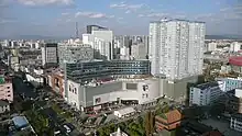
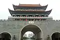
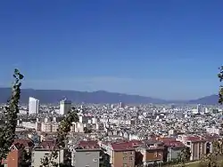
    From top, left to right: Baoshan Government, Yiluochi Park, Sunset in Beihai Wetland of Tengchong, "Hot sea"(a tourist attraction of Tengchong volcanic field) | |
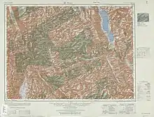
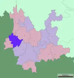 Location of Baoshan in Yunnan | |
| Coordinates (Baoshan municipal government): 25°06′43″N 99°09′40″E | |
| Country | People's Republic of China |
| Province | Yunnan |
| Admin HQ | Longyang |
| Area | |
| • Total | 19,064.6 km2 (7,360.9 sq mi) |
| Elevation | 1,677 m (5,502 ft) |
| Population (2010) | |
| • Total | 2,506,491 |
| • Density | 130/km2 (340/sq mi) |
| Time zone | UTC+8 (China Standard) |
| Postal code | 678000 |
| Area code | 0875 |
| ISO 3166 code | CN-YN-05 |
| Vehicle registration | 云M |
| Website | www |
Geography and climate
Baoshan is located between the border of Burma and the Lancang river (Mekong); specifically it borders the Burmese states of Kachin to the northwest and Shan to the south. The Nujiang (Salween River) flows through the entire length of the prefecture, north to south.
Tempered by the low latitude and moderate elevation, Baoshan has a mild subtropical highland climate (Köppen Cwb), with short, mild, dry winters and warm, rainy summers. Frost may occur in winter but the days still generally warm up to around 16 to 17 °C (61 to 63 °F), with a January average of 9.1 °C (48.4 °F). The warmest month is June, which averages 21.5 °C (70.7 °F). Nearly three quarters of the annual rainfall occurs from June to October.
| Climate data for Baoshan (1991–2020 normals, extremes 1971–2010) | |||||||||||||
|---|---|---|---|---|---|---|---|---|---|---|---|---|---|
| Month | Jan | Feb | Mar | Apr | May | Jun | Jul | Aug | Sep | Oct | Nov | Dec | Year |
| Record high °C (°F) | 22.4 (72.3) |
25.4 (77.7) |
28.9 (84.0) |
29.9 (85.8) |
32.4 (90.3) |
32.3 (90.1) |
31.3 (88.3) |
31.4 (88.5) |
30.1 (86.2) |
28.8 (83.8) |
25.2 (77.4) |
22.4 (72.3) |
32.4 (90.3) |
| Average high °C (°F) | 17.4 (63.3) |
19.3 (66.7) |
22.3 (72.1) |
24.5 (76.1) |
25.9 (78.6) |
26.5 (79.7) |
25.8 (78.4) |
26.4 (79.5) |
25.7 (78.3) |
23.9 (75.0) |
20.8 (69.4) |
18.1 (64.6) |
23.1 (73.5) |
| Daily mean °C (°F) | 9.7 (49.5) |
11.8 (53.2) |
14.9 (58.8) |
17.6 (63.7) |
20.2 (68.4) |
21.9 (71.4) |
21.6 (70.9) |
21.5 (70.7) |
20.5 (68.9) |
18.2 (64.8) |
13.8 (56.8) |
10.4 (50.7) |
16.8 (62.3) |
| Average low °C (°F) | 3.5 (38.3) |
5.2 (41.4) |
8.4 (47.1) |
11.7 (53.1) |
15.5 (59.9) |
18.7 (65.7) |
18.9 (66.0) |
18.6 (65.5) |
17.3 (63.1) |
14.4 (57.9) |
8.8 (47.8) |
4.7 (40.5) |
12.1 (53.9) |
| Record low °C (°F) | −3.8 (25.2) |
−2.6 (27.3) |
−1 (30) |
2.7 (36.9) |
7.4 (45.3) |
12.4 (54.3) |
13.1 (55.6) |
13.0 (55.4) |
10.7 (51.3) |
5.5 (41.9) |
0.7 (33.3) |
−2.3 (27.9) |
−3.8 (25.2) |
| Average precipitation mm (inches) | 23.2 (0.91) |
21.0 (0.83) |
30.6 (1.20) |
45.4 (1.79) |
90.1 (3.55) |
100.4 (3.95) |
173.6 (6.83) |
196.2 (7.72) |
145.9 (5.74) |
102.7 (4.04) |
26.8 (1.06) |
8.3 (0.33) |
964.2 (37.95) |
| Average precipitation days (≥ 0.1 mm) | 3.6 | 5.0 | 7.7 | 10.7 | 12.0 | 15.2 | 21.4 | 21.3 | 16.1 | 12.2 | 4.5 | 2.6 | 132.3 |
| Average relative humidity (%) | 65 | 60 | 57 | 61 | 67 | 73 | 79 | 80 | 79 | 76 | 72 | 69 | 70 |
| Mean monthly sunshine hours | 247.1 | 232.8 | 254.9 | 236.6 | 221.9 | 162.6 | 116.2 | 144.1 | 159.9 | 191.7 | 229.2 | 239.8 | 2,436.8 |
| Percent possible sunshine | 74 | 73 | 68 | 62 | 54 | 40 | 28 | 36 | 44 | 54 | 71 | 73 | 56 |
| Source 1: China Meteorological Administration[1][2] | |||||||||||||
| Source 2: Weather China[3] | |||||||||||||
Administrative divisions
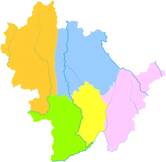
The city-prefecture of Baoshan has jurisdiction over five subdivisions — a district, one county-level city and three counties.
| Map | |||||
|---|---|---|---|---|---|
| Name | Hanzi | Hanyu Pinyin | Population (2010) | Area (km2) | Density (/km2) |
| Longyang District | 隆阳区 | Lóngyáng Qū | 935,618 | 5,011 | 187 |
| Tengchong City | 腾冲市 | Téngchōng Shì | 644,765 | 5,845 | 110 |
| Shidian County | 施甸县 | Shīdiàn Xiàn | 305,223 | 2,009 | 152 |
| Longling County | 龙陵县 | Lónglíng Xiàn | 277,319 | 2,884 | 96 |
| Changning County | 昌宁县 | Chāngníng Xiàn | 343,566 | 3,888 | 88 |
Tengyue, the other major populated area in the county, successfully lobbied for and achieved city status in 2015-16 and is currently in the process of separating itself and the surrounding Tengchong area from Baoshan administratively.
Demography
The prefecture has about 2.5 million inhabitants.
Ethnic groups
Among the resident population, the population of Han is 2,248,140, accounting for 89.69%; the population of ethnic minorities is 258,351, accounting for 10.31%.
| National name | Han | Yi | Bai | Dai | Lisu | Hui | Miao | Bulang | Wa | Jingpo | Others |
|---|---|---|---|---|---|---|---|---|---|---|---|
| Population | 2248140 | 81524 | 45890 | 43049 | 34423 | 12436 | 10580 | 9834 | 4833 | 4204 | 11578 |
| Proportion of total population (%) | 89.69 | 3.25 | 1.83 | 1.72 | 1.37 | 0.50 | 0.42 | 0.39 | 0.19 | 0.17 | 0.46 |
| Proportion of minority population (%) | --- | 31.56 | 17.76 | 16.66 | 13.32 | 4.81 | 4.10 | 3.81 | 1.87 | 1.63 | 4.48 |
Bulang
According to the Baoshan Ethnic Gazetteer (2006:337), ethnic Bulang are distributed in the following villages within Baoshan City.
- Shidian County
- Mulaoyuan (木老元乡): Mulaoyuan (木老元), Hazhai (哈寨), Dadi (大地), Longtang (龙塘)
- Bailang Township (摆榔乡): Jici (鸡茨), Dazhong (大中), Jianshan (尖山)
- Yaoguan Township (姚关乡): Duopo (陡坡)
- Jiufang Township (酒房乡): Yakou (哑口)
- Changning County
- Gengga Township (更嘎乡): Baicaolin (百草林), Dachushui (大出水)
- Kasi Township (卡斯镇)
- Xingu Village (新谷村): Guban (谷板), Zhongzhai (中寨)
- Kasi Village (卡斯村): Shuanglong (双龙), Yingbaizhai (应百寨), Ergoudi (二沟地)
De'ang
The Yaojing (尧净), a subgroup of the De'ang, are located in Baizhai (白寨), Laxian (拉线), and Dagoubian (大沟边) of Mangyan Village (芒颜村) and Shiti Village (石梯村) in Lujiang Township (潞江乡), Longyang District (Baoshan Ethnic Gazetteer 2006:490-491).
Transport
Baoshan lies on the main road from Ruili on the Burmese border to Kunming. The Baoshan−Kunming section is completed highway, and the Baoshan-Ruili part was completed in 2016, finalizing the highway net crossing Yunnan east-to-west. It is the first finished highway between China and Myanmar.
Baoshan Yunrui Airport (IATA: BSD, ICAO: ZPBS) has daily flights to and from Kunming.
The currently under construction Dali–Ruili railway will pass through Baoshan. Baoshan railway station will handle passenger services while Baoshan North will handle freight.
Notable people
- Gui Haichao — first Chinese civilian to enter space
See also
- Three Parallel Rivers of Yunnan Protected Areas — Unesco World Heritage Site
- Gaoligong Mountain
References
- 中国气象数据网 – WeatherBk Data (in Simplified Chinese). China Meteorological Administration. Retrieved 10 April 2023.
- 中国气象数据网 (in Simplified Chinese). China Meteorological Administration. Retrieved 10 April 2023.
- 保山 - 气象数据 -中国天气网 (in Chinese). Weather China. Retrieved 21 November 2022.
- Yunnan Provincial Census Office, Yunnan Provincial Bureau of Statistics (September 2012). "Yunnan Provincial Census Data in 2010". China Statistics Press. ISBN 978-7-5037-6548-3.
External links
- Baoshan City Official Site Archived 2015-11-02 at the Wayback Machine
- Baoshan Travel and Tourism Bureau (zh, en, ja)
- Baoshan News Network
- Baoshan profile Archived 2012-02-12 at the Wayback Machine
- Baoshan map Archived 2012-02-12 at the Wayback Machine