Dostpur, Lalganj
Dostpur is a village in Lalganj block of Rae Bareli district, Uttar Pradesh, India.[2] It is located 6 km from Lalganj, the block and tehsil headquarters.[3] As of 2011, it has a population of 295 people, in 59 households.[2] It has one primary school and no healthcare facilities.[2]
Dostpur | |
|---|---|
Village | |
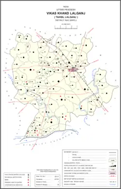 Map showing Dostpur (#820) in Lalganj CD block | |
 Dostpur Location in Uttar Pradesh, India | |
| Coordinates: 26.178383°N 80.918293°E[1] | |
| Country India | |
| State | Uttar Pradesh |
| District | Raebareli |
| Area | |
| • Total | 0.489 km2 (0.189 sq mi) |
| Population (2011)[2] | |
| • Total | 295 |
| • Density | 600/km2 (1,600/sq mi) |
| Languages | |
| • Official | Hindi |
| Time zone | UTC+5:30 (IST) |
| Vehicle registration | UP-35 |
The 1961 census recorded Dostpur as comprising 1 hamlet, with a total population of 187 people (94 male and 93 female), in 31 households and 25 physical houses.[4] The area of the village was given as 128 acres.[4]
The 1981 census recorded Dostpur as having a population of 248 people, in 40 households, and having an area of 51.81 hectares.[3] The main staple foods were listed as wheat and rice.[3]
References
- "Geonames Search". Do a radial search using these coordinates here.
- "Census of India 2011: Uttar Pradesh District Census Handbook - Rae Bareli, Part A (Village and Town Directory)" (PDF). Census 2011 India. pp. 288–306. Retrieved 16 August 2021.
- Census 1981 Uttar Pradesh: District Census Handbook Part XIII-A: Village & Town Directory, District Rae Bareli (PDF). 1982. pp. 132–3. Retrieved 16 August 2021.
- Census 1961: District Census Handbook, Uttar Pradesh (39 - Raebareli District) (PDF). Lucknow. 1965. pp. lxvi-lxvii of section "Dalmau Tahsil". Retrieved 14 August 2021.
{{cite book}}: CS1 maint: location missing publisher (link)
This article is issued from Wikipedia. The text is licensed under Creative Commons - Attribution - Sharealike. Additional terms may apply for the media files.