Dih, Raebareli
Dih, also spelled Deeh, is a dessert and corresponding community development block in Salon tehsil of Rae Bareli district, Uttar Pradesh, India.[2] It is located 22 km from Raebareli, the district headquarters,[3] near the point where the road to Parshadepur intersects the road leading from Jais to the Gukana ghat.[4] The Sai river flows a short distance to the south.[4] As of 2011, Dih has a population of 12,110 people, in 2,186 households.[2] It has three primary schools and no healthcare facilities, as well as a post office, a library, and an Anganwadi centre.[2] It is the headquarters of a nyaya panchayat, which also includes 8 other villages.[5]
Dih
Deeh | |
|---|---|
Village | |
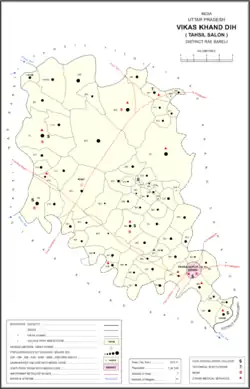 Map of Dih CD block | |
 Dih Location in Uttar Pradesh, India | |
| Coordinates: 26.142638°N 81.408559°E[1] | |
| Country India | |
| State | Uttar Pradesh |
| District | Raebareli |
| Area | |
| • Total | 5.49 km2 (2.12 sq mi) |
| Population (2011)[2] | |
| • Total | 7,267 |
| • Density | 1,300/km2 (3,400/sq mi) |
| Languages | |
| • Official | Hindi |
| Time zone | UTC+5:30 (IST) |
| Vehicle registration | UP-35 |
Dih hosts a large Ramlila festival[4] on Dussehra, involving a dramatic reenactment of the Ramayana.[6] It also hosts markets twice per week, on Tuesdays and Saturdays.[6] Major items sold include cloth, grain, gur, ornaments, and vegetables.[6]
History
Dih is named after the old deserted site to the north of the present village, but the old site's history is generally unknown.[4] At some point, Dih was held by the Bhale Sultans, but it was later conquered by the Kanhpurias "after a gallant defence."[4] At the turn of the 20th century, Dih was described as a large village surrounded by extensive orchards, irrigated by wells and a large tank on the north side of the village.[4] The village lands were mostly held by the taluqdar of Tikari, except for one small mahal which was held by Brahmin landlords and another, Bairagipur, which was revenue-free.[4] At that point, Dih had a primary school, a cattle pound, and a small bazar hosting markets twice per week.[4] The Ramlila fair was noted as having a large attendance at the time.[4] A village bank was established in June 1901.[4] As of the census that year, Dih had a population of 3,489 people, and Pasis were the main cultivating caste.[4]
The 1951 census recorded Dih as comprising 25 hamlets, with a total population of 4,067 people (2,103 male and 1,964 female), in 886 households and 829 physical houses.[7] The area of the village was given as 2,505 acres.[7] 275 residents were literate, 266 male and 9 female.[7] The village was listed as belonging to the pargana of Parshadepur and the thana of Nasirabad.[7]
The 1961 census recorded Dih (as "Deeh") as comprising 17 hamlets, with a total population of 4,011 people (2,083 male and 1,928 female), in 899 households and 866 physical houses.[6] The area of the village was given as 2,503 acres and it had a post office at that point.[6] Average attendance of the twice-weekly market was about 2,000 people at the time, while attendance of the Dussehra festival was about 6,000.[6]
The 1981 census recorded Dih (as "Deeh") as having a population of 6,571 people, in 1,735 households, and having an area of 1,013.77 hectares.[3] The main staple foods were listed as wheat and rice.[3]
The 1991 census recorded Dih (as "Deeh") as having a total population of 8,393 people (4,443 male and 3,950 female), in 1,601 households and 1,601 physical houses.[5] The area of the village was listed as 985 hectares.[5] Members of the 0-6 age group numbered 1,798, or 21% of the total; this group was 51% male (958) and 49% female (840).[5] Members of scheduled castes made up 43% of the village's population, while no members of scheduled tribes were recorded.[5] The literacy rate of the village was 28% (1,788 men and 561 women).[5] 2,965 people were classified as main workers (2,245 men and 720 women), while 365 people were classified as marginal workers (26 men and 339 women); the remaining 5,063 residents were non-workers.[5] The breakdown of main workers by employment category was as follows: 1,307 cultivators (i.e. people who owned or leased their own land); 1,041 agricultural labourers (i.e. people who worked someone else's land in return for payment); 19 workers in livestock, forestry, fishing, hunting, plantations, orchards, etc.; 0 in mining and quarrying; 9 household industry workers; 89 workers employed in other manufacturing, processing, service, and repair roles; 50 construction workers; 223 employed in trade and commerce; 13 employed in transport, storage, and communications; and 214 in other services.[5]
Villages
Dih CD block has the following 71 villages:[2]
| Village name | Total land area (hectares) | Population (in 2011) |
|---|---|---|
| Rawari Saidpur | 145.2 | 1,341 |
| Baitaura | 526.1 | 4,368 |
| Majhilaha | 452.3 | 3,015 |
| Pothai | 914.4 | 6,256 |
| Kokhar | 203.1 | 853 |
| Rokha | 1,899.1 | 10,292 |
| Mau | 1,544.1 | 7,121 |
| Bahutai | 239.1 | 2,040 |
| Thauri | 163.7 | 1,225 |
| Dinapur | 18 | 184 |
| Pure Bansi | 68.1 | 667 |
| Kiya | 92.8 | 846 |
| Raipur Todi | 130.2 | 954 |
| Gopalpur | 91.8 | 521 |
| Tekari Dandu | 893.4 | 6,956 |
| Tekari Sahan | 369.1 | 2,770 |
| Nigohi | 275 | 2,074 |
| Garwa | 150 | 1,485 |
| Dela | 392 | 2,803 |
| Kurapur Gaura | 98.6 | 873 |
| Jagdishpur | 551.4 | 4,538 |
| Deeh (block headquarters) | 990.6 | 12,110 |
| Sarai Manik | 573.5 | 4,433 |
| Ahal | 159.1 | 1,854 |
| Kol | 65 | 216 |
| Goera | 157 | 619 |
| Ghisi Garh | 600.5 | 917 |
| Kachnawan | 344.7 | 3,340 |
| Sadipur Kotwa | 173.4 | 1,850 |
| Sirsi | 262.2 | 1,395 |
| Hamiri Patti | 49.6 | 242 |
| Kamalpur Baraila | 175.7 | 1,174 |
| Birnawan | 1,603.3 | 10,295 |
| Pradhanpur | 53.7 | 937 |
| Kharika | 25.4 | 112 |
| Pure Shiv Baksh | 14 | 236 |
| Baramjitpur | 33.2 | 84 |
| Lodipur | 13.5 | 86 |
| Ghatampur | 122.5 | 1,059 |
| Rajhanpur | 92 | 0 |
| Pirhi | 130.2 | 794 |
| Satanpur | 42.5 | 241 |
| Narayanpur | 91.8 | 593 |
| Bikapur | 53.7 | 502 |
| Dohri | 109.5 | 844 |
| Khetau Dhan | 345.5 | 2,919 |
| Govindpur | 108.1 | 402 |
| Vakalangarh | 101 | 382 |
| Pukh Nain | 190 | 1,291 |
| Gopalpur | 398.4 | 1,808 |
| Sher Nathpur | 124.9 | 357 |
| Ashapur | 114.9 | 501 |
| Rasidpur | 911.5 | 1,633 |
| Atawan | 285.8 | 2,108 |
| Surayya Muvakkil | 27 | 1,029 |
| Baswa | 261.4 | 1,631 |
| Dilawalpur | 319.1 | 1,683 |
| Pure Thamman | 51.4 | 987 |
| Khan Jahanpur | 15.3 | 284 |
| Kishunpur | 16.4 | 493 |
| Padmanpur Vinauli | 34.8 | 1,689 |
| Dhan Kesara | 859.7 | 569 |
| Gangapur Kamwan | 249.5 | 971 |
| Sunga | 342.1 | 847 |
| Sansari | 130 | 427 |
| Ahora Rampur | 389.3 | 743 |
| Phagoopur | 393 | 2,195 |
| Bachhawal Khurd | 53.4 | 751 |
| Hajipur | 218.4 | 1,387 |
| Maheshpur | 116 | 760 |
| Madhukarpur | 159.3 | 1,166 |
References
- Do a radial search using these coordinates here https://geonames.nga.mil/namesgaz/.
{{cite web}}: Missing or empty|title=(help) - "Census of India 2011: Uttar Pradesh District Census Handbook - Rae Bareli, Part A (Village and Town Directory)" (PDF). Census 2011 India. pp. 393–409. Retrieved 29 August 2021.
- Census 1981 Uttar Pradesh: District Census Handbook Part XIII-A: Village & Town Directory, District Rae Bareli (PDF). 1982. pp. 212–3. Retrieved 29 August 2021.
- Nevill, H.R. (1905). Rai Bareli: A Gazetteer, Being Volume XXXIX Of The District Gazetteers Of The United Provinces Of Agra And Oudh. Allahabad: Government Press. p. 173. Retrieved 29 August 2021.
- Census 1991 Series-25 Uttar Pradesh Part-XII B Village & Townwise Primary Census Abstract District Census Handbook District Raebareli (PDF). 1992. pp. xxiv–xxviii, 240–1. Retrieved 17 October 2021.
- Census 1961: District Census Handbook, Uttar Pradesh (39 - Raebareli District) (PDF). Lucknow. 1965. pp. 170–1, 176, civ-cv of section "Salon Tahsil". Retrieved 29 August 2021.
{{cite book}}: CS1 maint: location missing publisher (link) - Census of India, 1951: District Census Handbook Uttar Pradesh (42 - Rae Bareli District) (PDF). Allahabad. 1955. pp. 160–1. Retrieved 17 October 2021.
{{cite book}}: CS1 maint: location missing publisher (link)