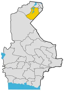
Hamun County
Hamun County (Persian: شهرستان هامون) is in Sistan and Baluchestan province, Iran.[3] Its capital is the city of Mohammadabad.[4]
Hamun County
Persian: شهرستان هامون | |
|---|---|
County | |
 Location of Hamun County in Sistan and Baluchestan province | |
 Location of Sistan and Baluchestan province in Iran | |
| Coordinates: 30°33′09″N 61°05′01″E[1] | |
| Country | Iran |
| Province | Sistan and Baluchestan |
| Capital | Mohammadabad |
| Districts | Central, Teymurabad |
| Population (2016)[2] | |
| • Total | 41,017 |
| Time zone | UTC+3:30 (IRST) |
At the 2006 census, the region's population (as Shib Ab District of Zabol County) was 43,374 in 9,809 households.[5] The following census in 2011 counted 41,520 people in 10,623 households.[6] At the 2016 census, the county's population was 41,017 in 11,380 households,[2] by which time Shib Ab District had been separated from Zabol County to form Hamun County. It was then divided into the Central and Teymurabad Districts.[4]
Administrative divisions
The population history and structural changes of Hamun County's administrative divisions over three consecutive censuses are shown in the following table. The latest census shows two districts, four rural districts, and two cities.[2]
| Administrative Divisions | 2006[5] | 2011[6] | 2016[2] |
|---|---|---|---|
| Central District | 30,683 | 34,040 | 34,570 |
| Lutak Rural District | 14,019 | 13,167 | 12,797 |
| Mohammadabad Rural District | 14,489 | 13,641 | 13,526 |
| Mohammadabad (city) | 2,175 | 2,681 | 3,468 |
| Shahr-e Jadid-e Ramshar (city) | |||
| Shahrak-e Ali Akbar (city) | 4,551 | 4,779 | |
| Teymurabad District | 12,691 | 7,480 | 6,290 |
| Kuh-e Khajeh Rural District | 6,482 | 1,601 | 1,434 |
| Teymurabad Rural District | 6,209 | 5,879 | 4,856 |
| Shahrak-e Ali Akbar (city) | |||
| Total | 43,374 | 41,520 | 41,017 |
| 1As a part of Zabol County at the 2006 and 2011 censuses | |||
References
- OpenStreetMap contributors (10 April 2023). "Hamun County" (Map). OpenStreetMap. Retrieved 10 April 2023.
- "Census of the Islamic Republic of Iran, 1395 (2016)". AMAR (in Persian). The Statistical Center of Iran. p. 11. Archived from the original (Excel) on 23 December 2021. Retrieved 19 December 2022.
- Iranian National Committee for Standardization of Geographical Names website (in Persian)
- Rahimi, Mohammadreza. "Seven new counties were added to the map of country divisions". DOLAT (in Persian). Ministry of Interior, Board of Ministers. Archived from the original on 8 January 2013. Retrieved 10 April 2023.
- "Census of the Islamic Republic of Iran, 1385 (2006)". AMAR (in Persian). The Statistical Center of Iran. p. 11. Archived from the original (Excel) on 20 September 2011. Retrieved 25 September 2022.
- "Census of the Islamic Republic of Iran, 1390 (2011)" (Excel). Iran Data Portal (in Persian). The Statistical Center of Iran. p. 11. Retrieved 19 December 2022.
