Kashmore District
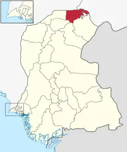
Kashmore District (Sindhi: ضلو ڪشمور, Urdu: ضلع کشمور), previously known as Khizmer or Khizmore, is a district of the province of Sindh, Pakistan. The capital city is Kandhkot. The district has a population of 1,090,336. Kashmore District is a part of Larkana Division. Its old name was Khizmer or Khizmor. The spoken languages are Sindhi and Balochi. Its border is connected with Punjab and Balochistan provinces. Kashmore city is gateway to Punjab province and Balochistan province.[2] In 2004, Kashmore became a district after its separation from Jacobabad District.
Kashmore District
| |
|---|---|
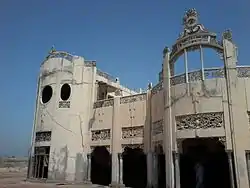 Haveli near Tangwani | |
 | |
| Coordinates: 28°21′N 69°23′E | |
| Country | |
| Province | |
| Division | Larkana |
| Headquarters | Kandhkot |
| Government | |
| • Type | District Administration |
| • Deputy Commissioner | N/A |
| • District Police Officer | N/A |
| • District Health Officer | N/A |
| Area | |
| • Total | 2,592 km2 (1,001 sq mi) |
| Population (2017)[1] | |
| • Total | 1,090,336 |
| • Density | 420/km2 (1,100/sq mi) |
| Time zone | UTC+5 (PST) |
| Number of Tehsils | 3 |
Administrative divisions
Kashmor District is subdivided into three tehsils:
The tehsils are further subdivided into union councils:
| U.C. No. | U.C. Name | Taluka |
|---|---|---|
| 1 | Line Purani | Kashmore |
| 2 | Khoski | Kashmore |
| 3 | Masowalo | Kashmore |
| 4 | Domiwali | Kashmore |
| 5 | Geehal Pur | Kashmore |
| 6 | Gullan Pur | Kashmore |
| 7 | Sodhi | Kashmore |
| 8 | Noor Pur Pako | Kashmore |
| 9 | Chachar | Kashmore |
| 10 | Badani | Kashmore |
| 11 | Gublo | Kashmore |
| 12 | Mahar | Kashmore |
| 13 | Toj | Kashmore |
| 14 | Kumb | Kashmore |
| 15 | Samao | Kashmore |
| 16 | Kumbiri | Kashmore |
| 17 | Zorgrah | Kashmore |
| 18 | Mulgulzar | Kandhkot |
| 19 | Rasaldar | Kandhkot |
| 20 | Jagirabad | Kandhkot |
| 21 | Dolat Pur | Kandhkot |
| 22 | Wakro | Kandhkot |
| 23 | Akhero | Kandhkot |
| 24 | Malheer | Kandhkot |
| 25 | Haibat | Kandhkot |
| 26 | Dadar | Kandhkot |
| 27 | Mangi | Kandhkot |
| 28 | Jaffar Abad | Tangwani |
| 29 | Cheel | Tangwani |
| 30 | Lashari | Tangwani |
| 31 | Bijarani | Tangwani |
| 32 | Suhliani | Tangwani |
| 33 | Manjhi | Tangwani |
| 34 | Gulwali | Tangwani |
| 35 | Saifal | Tangwani |
| 36 | Saido Kot | Tangwani |
| 37 | Karam Pur | Tangwani |
| 38 | Sher Garh | Tangwani |
| 39 | Dunyapur | Tangwani |
| 40 | Naseer | Tangwani |
| 41 | Bahalkani | Tangwani |
Agriculture
Kashmor District has a large cattle market.
Geography
Kashmor District is located in the northern part of Sindh, bordering Ghotki, Jacobabad, Shikarpur and Sukkur within Sindh. It also borders Balochistan on one side and Punjab on the other. The Indus river runs through the Eastern side of Kashmor district. The southeastern side of Kashmor District has forest of "Kacha" that support wild animals. The Thar desert falls on the Eastern side of the district, and is home to wild desert animals.
Demography
At the time of the 2017 census, Kashmore district had a population of 1,090,336, of which 253,659 (23.26%) lived in urban areas. Kashmore had a sex ratio of 931 females per 1000 males and a literacy rate of 30.58%: 41.76% for males and 18.59% for females.[1]
| Religion | Population (1941)[3]: 54–57 | Percentage (1941) | Population (2017)[1] | Percentage (2017) |
|---|---|---|---|---|
| Islam |
114,389 | 92.81% | 1,054,657 | 96.73% |
| Hinduism |
8,825 | 7.16% | 35,122 | 3.22% |
| Others [lower-alpha 2] | 32 | 0.03% | 557 | 0.05% |
| Total Population | 123,246 | 100% | 1,090,336 | 100% |
The majority religion is Islam, with 96.73% of the population. Hinduism (including those from Scheduled Castes) is practiced by 3.22% of the population.[1]
At the time of the 2017 census, 94.34% of the population spoke Sindhi, 2.99% Balochi and 1.05% Saraiki as their first language.[1]
Kashmor City
Kandhkot is the district headquarters of Kashmor, and also an old city that lies on the right side of the Indus river. Kashmore City is a gateway to Punjab and Balochistan. In addition, the city’s main electricity comes from the Indus river.
List of Dehs
The following is a list of Kashmore District's dehs, organised by taluka:[4]
- Kashmore Taluka (57 dehs)
- Badani Kacho
- Badani Pako
- Bai Rup
- Belo
- Bhanar
- Bindp Murad
- Buxapur
- Chachar
- Daro Jhando
- Domewali
- Elsi
- Gandheer
- Geehalpur
- Gishkori
- Gondak Kosh
- Gublo
- Gullanpur
- Haji Khan
- Jakhrani
- Jalal Sudh
- Kacho Bahadurpur
- Kacho Kashmore
- Kacho Khoski
- Karimabad
- Kath Garh
- Kauro Mahar
- Keejhar
- Khahi Kacho
- Khahi Pako
- Khewali
- Kubhar
- Kumb
- Kumbhri
- Line Purani
- Machhi
- Mahar
- Masoowalo
- Mekhan Bello
- Mithri
- Muhammadadani
- Noorpur Kacho
- Noorpur Pako
- Pako Bahadurpur
- Pako Kashmore
- Pako Khoski
- Rio Kacho
- Sain
- Samo
- Shah Ali Pur
- Shah Garh Kacho
- Shah Garh Pako
- Silachi
- Sodhi
- Sorah
- Thalho
- Toj
- Zor Garh
- Kandhkot Taluka (49 dehs)
- Aalamabad
- Akhero
- Arain
- Babarwari
- Balochabad
- Bilhari
- Buxpur
- Chaman
- Dadar
- Dari
- Dhabhani
- Dhandhi
- Dhao
- Lahri Domki
- Doulatpur
- Fareed abad
- Garhi
- Ghoraghar Katcho
- Ghoraghat Pako
- Ghouspur
- Gulabpur
- Haibat Katcho
- Haibat Pako
- Jaffarabad Katcho
- Jageerabad
- Jangin
- Kajli
- Kandhkot
- Keti
- Khairwah
- Khan wah
- Khanbhri
- Kundharo Katcho
- Machko
- Makan maro
- Makhwani
- Malguzar
- Malheer
- Malookan
- Mangi
- Mari
- Metahar
- Rasaldar
- Rejmatabad
- Shah Mohammad Jeelani
- Sunhiyanipur
- Teghani
- Wahidpur
- Wakro
- Tangwani Taluka (42 dehs)
- Allah abad
- Bahalkani
- Bargh
- Beghoo
- Bijarani
- Cheel
- Dabli
- Duniyapur
- Gazi
- Ghano Khoso
- Gudo
- Gulwali
- Hajano
- Hazaro
- Heeranpur
- Jaffarabad
- Jamal
- Jhalo
- Karampur
- Kair
- Khairo
- Kot dothi
- Lalao
- Lashari
- Manjhi
- Mari Jafar
- Nar
- Naseer
- Ninde ji Dhori
- Qureshi
- Saido kot
- Saifal
- Salghni
- Sanheri
- Sawan Gabol
- Shah gazi
- Sher garh
- Sherhan
- Sorwah
- Suhliyani
- Tangwani
- Unar
Notes
- Kashmore and Kandhkot taluks of Upper Sindh Frontier district
- Including Jainism, Christianity, Buddhism, Zoroastrianism, Judaism, Ad-Dharmis, or not stated
References
- "District-wise Tables - Census 2017 Final Results". pbs.gov.pk. Pakistan Bureau of Statistics. 2017.
- "Sindh population surges by 81.5 pc, households by 83.9 pc". Thenews.com.pk. 2 April 2012. Retrieved 2016-12-26.
- "CENSUS OF INDIA, 1941 VOLUME XII SINDH PROVINCE" (PDF).
- "List of Dehs in Sindh" (PDF). Sindh Zameen. Retrieved 22 March 2021.
Bibliography
- 1998 District census report of Jacobabad. Census publication. Vol. 17. Islamabad: Population Census Organization, Statistics Division, Government of Pakistan. 1999.
Provincial capital: Karachi | ||
| Banbhore | 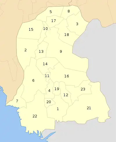 | |
| Hyderabad | ||
| Karachi | ||
| Larkana | ||
| Mirpur Khas | ||
| Sukkur | ||
| Shaheed Benazir Abad | ||