Jamshoro District
Jamshoro District (Sindhi: ضلعو ڄام شورو, Urdu: ضلع جامشورو), is a district of Sindh province, Pakistan. Jamshoro city is the capital while Kotri is the largest city of the Jamshoro District. The district borders Dadu district to the north. To the east, the Indus separates it from Nawab Shah, Matyari and Hyderabad districts. Thatta district lies to the south, and Karachi district to the south west. To the west, the Kheerthar Range separates it from the Sindh and Lasbela district of Baluchistan.
Jamshoro District
| |
|---|---|
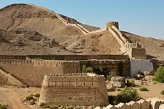 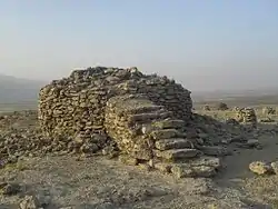 Top: Ranikot Fort Bottom: Buddhist Stupa at Naig Sharif | |
 Map of Pakistani Districts with Jamshoro District highlighted | |
| Coordinates: 25.432512°N 68.263171°E | |
| Country | |
| Province | |
| Division | Hyderabad |
| Established | 14th December 2004 |
| Headquarters | Jamshoro |
| Government | |
| • Type | District Administration |
| • Deputy Commissioner | N/A |
| • District Police Officer | N/A |
| • District Health Officer | N/A |
| Area | |
| • Total | 11,260 km2 (4,350 sq mi) |
| Population (2017)[1] | |
| • Total | 993,908 |
| • Density | 88/km2 (230/sq mi) |
| Time zone | UTC+5 (PST) |
| Number of Tehsils | 5 |
Jamshoro District was split from Dadu District in 14th December 2004[2] It is situated on the west bank of River Indus.
Geography
The total geographical area of the district is 11,260 square kilometres. It is about 220 kilometers from north to south and about 100 kilometres wide from east to west. A 2 to 6 kilometres wide belt of the west bank of River Indus is cultivated and irrigated and the remaining land of the district is either hilly or cultivated. Agriculture is the main source of income. In summer, the northern part (Sehwan) is hotter than that of other parts of the district and normally cool in winter.
The district is rich in limestone, salika sand, gravels, silt, and marble. These minerals are found in Taluka Thano Bula Khan and Sehwan. Coal is obtained from Lakhra Taluka Manjhand.
Demographics
At the time of the 2017 census, Jamshoro district had a population of 993,908, of which 523,069 were males and 470,702 females. The rural population was 561,287 (56.47%) and urban 432,621 (43.53%). The literacy rate is 46.47%: 55.14% for males and 36.71% for females.[1]
The current population figures are tabulated below:
| Name | Status | Population Census 1998 | Population Census 2017 |
|---|---|---|---|
| Kotri | Taluka | 207,574 | 438,063 |
| Manjhand | Taluka | 100,105 | 140,766 |
| Sehwan | Taluka | 170,589 | 269,817 |
| Thana Bulla Khan | Taluka | 103,826 | 145,262 |
| Jamshoro | District | 582,094 | 993,908 |
Religion
The majority religion is Islam, with 95.07% of the population. Hinduism (including those from Scheduled Castes) is practiced by 3.87% of the population, while Christians are 0.98% of the population.[1]
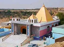
- Hindu temples
- Gobindram Darbar at Manjhand
- Kathwari Harijan Manhar Mandir
Economy
The majority of the population of the district is rural and they are involved in cultivation. Industrial areas and Power plants are using manpower, while towns are providing business opportunities to the residents. The inhabitants of mountainous area keep cattle while Mallahs o Manchhar Lake earn their living by fishing. Approximately 20% of the district population works for the federal and provincial government.
Nooriabad Industrial Area and Kotri Industrial Area are two big zones of Industries where more than 500 different industries are located..
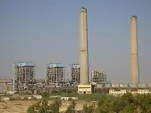
Jamshoro Power Station, Lakhra Power Project and Kotri Thermal Power Station are the main power units in this district.
Sindh Industrial And Trading Estate
Two main town's of Sindh Industrial and Trading Estate are in Jamshoro District, Kotri and Nooriabad. Having more than 500 production plants which produces Cotton, Rice, Flour, Oil and many more.[3]
Education
Mehran University of Engineering and Technology, Liaquat University of Medical and Health Sciences and University of Sindh are located in Jamshoro.
Administrative divisions
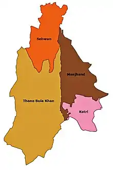
The district is administratively subdivided into the following tehsil:
- Kotri Tehsil
- Sehwan Sharif Tehsil
- Thana Bulla Khan Tehsil
- Manjhand Tehsil
List of Union Councils
Jamshoro District includes the following Union Councils:[4]
| UC Name | Population |
|---|---|
| Nagoline | 35,788 |
| Kotri | 29,861 |
| H.M. Shoro | 43,728 |
| A.B. Shoro | 42,100 |
| S.W. I | 49,723 |
| S.W. II | 54,079 |
| S.W. III | 42,466 |
| Jamshoro | 42,526 |
| Morojabal | 30,301 |
| Petaro | 28,487 |
| Sehwan Sharif | 36,359 |
| Sehwan II | 45,384 |
| Channa | 39,954 |
| Talti | 37,694 |
| Bubak | 28,776 |
| Bhan | 46,962 |
| Jhangara | 34,678 |
| Dall | 45,383 |
| Manjhand | 35,522 |
| Manzoorabad | 34,047 |
| Lakha | 32,384 |
| Sann | 33,400 |
| Amri/Laki | 33,842 |
| T.B. Khan | 43,705 |
| T.A. Khan | 39,067 |
| Toung | 33,762 |
| Mole | 36,750 |
| Sari | 39,079 |
List of Dehs
The following is a list of Jamshoro District's dehs, organised by taluka:[5]
- Kotri Taluka (26 dehs)
- Andhi-Je-Kasi
- Bada Jaghir
- Bada Rayati
- Belo Gugh
- Chhib
- Dabhon
- Kandh Wingo
- Karo-Khoho
- Khanpur, Jamshoro
- Kotri
- Manjho Jagir
- Manhjo Rayti
- Morho Jabal
- Mulas
- Nadhi Buhni
- Petaro Jagir
- Petaro Rayati
- Rahir
- Railo
- Saloi
- Sonwalhar
- Tango
- Tarband
- Ukhri Kass
- Vee
- Wagan Wari
- Manjhand Taluka (50 dehs)
- Abad
- Amri
- Badhpur
- Belo Unerpur
- Bhacha
- Bhadar
- Bhambhara
- Bhiyan
- Bhorawah
- Bug
- Butho
- Chachhar
- Dabhi
- Dabhri
- Dumb
- Elchi
- Gaincha
- Givari
- Gor Had
- Jhalo
- Kachi
- Kandher
- Karahi
- Kastor
- Khakoor
- Khasai
- Kheraji
- Khuman
- Korejani
- Kubi
- Kun
- Lakha
- Lakhri
- Laki
- Lellan
- Manjhand
- Meeting
- Nea Jetharo
- Noorpur
- Ocho
- Rajri
- Rio Katcho Unerpur
- Sann
- Shoorki
- Tangyani
- Thatti
- Thebat
- Unerpur
- Wachharo
- Wadi Behani
- Sehwan Taluka (71 dehs)
- Abad
- Akri Jageer
- Akri Rayati
- Aktar
- Arazi
- Arbi
- Bado Jabal
- Bagh Yousif
- Baid
- Bajara
- Barki
- Bhambha
- Bhan
- Bhootra
- Bhundhri
- Bilawalpur
- Bilhan
- Bilhni
- Bubuk
- Bukhtiar Pur
- Channa
- Chhachh
- Chorlo
- Dal
- Dalh
- Dhandh-Karampur
- Duri Dero Jageer
- Duri Dero Rayati
- Fazlani
- Gahir
- Gumrachh
- Jafferabad
- Jaheja
- Jatoi
- Jhandiani
- Jhangara
- Kachhi
- Kai
- Kalo Bhori
- Kandi Jabal
- Karampur
- Karyani
- Khabroth Jageer
- Khabroth Rayati
- Khero Dero
- Kot Barocho
- Lashari
- Maheji
- Miliriri
- Munh-Mukhri
- Naing
- Narpirari
- Nighawal
- Peer Hassan
- Radhok
- Rohri
- Saeedabad
- Sehwan
- Shah Gorch
- Shaikh
- Sultanpur
- Super
- Talabad Jabal
- Talti
- Tando Shahbazi
- Tehni
- Therhi Jageer
- Therhi Rayati
- Wahur
- Wanchha
- Yakubani
- Thano Bula Khan Taluka (28 dehs)
- Babar Band
- Bachani
- Batharo-Karchat
- Beli Thap
- Bhall
- Desvi
- Dhamach
- Ghanghiaro
- Hathal Buth
- Kalo Khohar
- Kande-Tarai
- Kapat
- Khajoor
- Koh-Tarash
- Loyachh-Doda Khan
- Loyachh-Sardar Khan
- Mole
- Pat-Karchat
- Pokhan
- Rani Kot
- Rek
- Sari
- Tak Makan
- Thando Arab Khan
- Tiko Baran
- Toung
- Uth Palan
- Wahi Arab Khan
References
- "District-wise Tables - Census 2017 Final Results". pbs.gov.pk. Pakistan Bureau of Statistics. 2017.
- "Four new districts created in Sindh". 2004. Retrieved 12 August 2021.
- "Sindh Industrial Trading Estates Ltd – Just another WordPress site". Archived from the original on 2019-02-02. Retrieved 2018-07-13.
- "Union Council wise Thematic Analysis". Department of Health, Government of Sindh. Retrieved 25 December 2021.
- "List of Dehs in Sindh" (PDF). Sindh Zameen. Retrieved 22 March 2021.
Bibliography
- 1998 District census report of Dadu. Census publication. Vol. 82. Islamabad: Population Census Organization, Statistics Division, Government of Pakistan. 2000.
Provincial capital: Karachi | ||
| Banbhore | 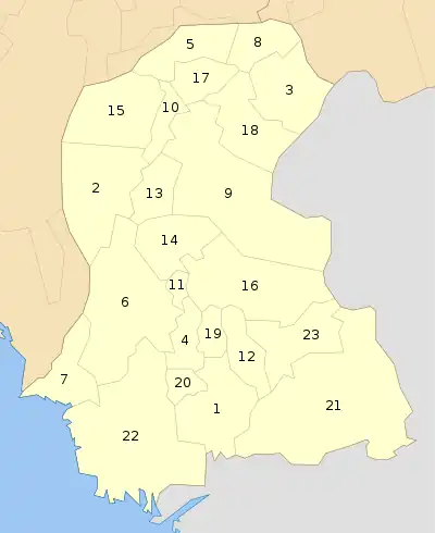 | |
| Hyderabad | ||
| Karachi | ||
| Larkana | ||
| Mirpur Khas | ||
| Sukkur | ||
| Shaheed Benazir Abad | ||